Roughly 88% of the world’s population lives in the northern hemisphere, and about half the world’s population lives north of 27°N. Taking the northern and southern hemispheres together, on average the world’s population lives 24 degrees from the equator.
There are a lot of Wikipedia visualizations. Some concentrate on article contents, others on the links between articles and some use the geocoded content (like in my previous blog post).
This new visualization is novel because it uses the geographical content of Wikipedia in conjunction with the links between articles. In other words, if a geocoded article (that is, an article associated with a location like a city) links to another geocoded article, a line will be drawn between these two points. The result can be found on the map on the left.
Antarctica (September 21st, 2005). The terrain and cloud cover are taken from images in 2004 and 2002 respectively.
The Antarctic is in some ways the opposite of the Arctic. The Arctic is an ocean basin surrounded by land, whereas the Antarctic is a continent surrounded by water.
In the Northern Hemisphere, sea ice can extend southwards to a latitude of 45°N (along the north-east coasts of Asia and North America), but most of the ice is above 70°N. In the Southern Hemisphere, the ice doesn’t get that close to the South Pole. It fringes the continent, and extends northwards to 55°S at its greatest extent.
Because of this, Antarctic sea ice coverage is larger in winter than in the Arctic, but smaller in summer. Total Antarctic sea ice peaks in September (beginning of spring) to a historical extent of 17 – 20 million square kilometres. The minimum extent is in February (end of summer), at about 3 – 4 million square kilometres.
Antarctic sea ice is distributed around the entire fringe of the continent, a much broader area than in the Arctic. It is also exposed to a broader range of land, ocean and atmospheric influences. Because of this geographic and climate diversity, the Antarctic sea ice is more variable from year to year. Climate oscillations don’t affect all areas in the same way. Therefore, it is more difficult to make overall generalizations about the influence of climate patterns here.
The Antarctic Oscillation involves a large-scale “see-sawing” of atmospheric mass between the pole and mid-latitudes. This oscillation can intensify, weaken, or shift the location of low- and high-pressure weather systems. These changes influence wind speeds, temperature, and the track that storms tend to follow. Any of these things can influence sea ice extent.
During a “positive phase”, the westerly winds circling Antarctica strengthen and move southwards (inwards). This can change the way ice is distributed among the sectors. It also isolates much of the Antarctic atmosphere.
These stronger winds have an overall cooling effect, but also cause a dramatic warming on the Antarctic Peninsula. This is because warmer air above the oceans to the north is drawn southwards (inwards). In general, these winds can lessen sea ice in some areas and increase it in others, because it can drive the ice further away from the coast or closer towards it, depending on the region.
I made these as a way to compile all the geographical vocabulary that I thought was useful and interesting for writers. Some descriptors share categories, and some are simplified, but for the most part everything is in its proper place. Not all the words are as useable as others, and some might take tricky wording to pull off, but I hope these prove useful to all you writers out there!
okay but I must know, does OP realize that the other orange bit is ALSO michigan?
because I simply cannot understand calling a state “not shaped weird” when it’s in TWO PIECES, separated by the FIFTH LARGEST LAKE IN THE WORLD
coming out of my cave because my newsfeed is filled with gordon lightfoot and i just need people to know that not only is it the 45th anniversary of when the edmund fitzgerald sank but that it sank on lake superior (aka the top of this weird michigan-great lake sandwich aka the largest lake by surface area 3rd/4th by volume depending) along a stretch called the “shipwreck coast” not far from whitefish point which is considered the “graveyard of the great lakes” and that doesn’t even begin to address that the number of ships that have gone down is probably in the thousands??????
so uh that imagery is uncomfortably accurate whoops
yes good, thank you for this addition. I was trying to find some way to express “this isn’t just some measly little lake. this is an unknowable and probably haunted force of nature that doesn’t care about you or your family or your neighbors” but I couldn’t make the words happen.
the fact that people decided “yeah we can count two pieces on either side of that as the same” is absolutely WILD to me, especially since rivers define like half the borders in this country. Rivers? nah we cannot possibly occupy both sides of it. Big scary lake? sure why not!
This is a map of Asia. North Americans, you may notice this map is not solely comprised of Japan, Korea, China and Thailand. People in the UK, you may notice India is not a continent. That is, if those of you who generalize entire continents can even pinpoint India on a map. Indians are Asian, gasp! And not all brown skinned people are Indian, also, gasp! There are an alarming amount of people, of all ages, from all backgrounds, who seem to be unable to process this.
I’m ethnically Asian. Since Asia is an extremely large continent, I could be from any number of countries. I am neither from India, China, Korea, Japan or Pakistan, yet not so surprisingly, I am stillAsian.
Yes, there are commonalities across regions, through the conflation of cultures, colonialism, globalization, transnationalism and movement of diasporas. Sometimes these are all the same thing. Rickshaws, rice and curry can be found across the continent. But let’s not overgeneralize. You can also find Buddhists, Catholics, Muslims and Hindus across Asia. Cantonese Speaking Chinese Muslims! English Speaking Indian Jews!
No, we are not all the same. Orientalism? (Please look up Edward Said for basic concepts) No thank you.
Geography, people. It’s important.
This pops up on my dash every so often. I reblog it again, not just because I wrote it, but because nothing has changed since I first posted this.
What’s cool about Iran is that it falls in 3 different regions of Asia so depending on what part of Iran you’re in, you can kind of get culture shocked a bit. The central and western part of the country is West Asia, the north east is Central Asia, and the southeast is in South Asia.
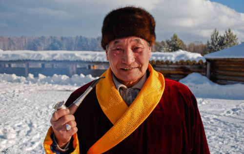
To the folks wondering about Russia being included, I want to mention that the cultural debates and angst about that has been going on for CENTURIES. While France has been pretty fetishized all the way back from Peter the Great, there is no question that we are not Europe, even with that influence showing really obviously in historical seats of power like St. Petersburg. Nonetheless, the whole country was under control of the Mongols (The Golden Horde) from roughly 1242 to 1480, and that left an enormous Mongolian and Tatar heritage that remains to this day. The ancient Scythians are huge in the cultural imagination as well. And besides… look at the Russians who are outside the standard “Kievan Rus” phenotype (which most folks assume is how all Russians look.)
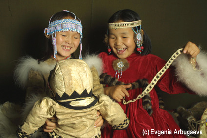
Here are three of the 30 distinct ethnic groups in Siberia alone:
Buryat grandfather, photo by Alexander Newby
Evenk children, photo by Evgenia Arbugaeva
Young Yakut couple, photographer unknown
boom
AS SOMEONE WITH NORTHERN IRANIAN (AZERBAIJANI)/RUSSIAN/ HAZARA-PERSIAN/ UYGHUR-CHINESE ANCESTRY THIS IS SUCH A BEAUTIFUL POST
And that’s why sometimes you’ll see a person with curly black hair, pale skin, and hazel-green eyes (my grand-father’s sister) who turn out to be Chinese. Mad recessive genes game at play, I swear. Mongols, they really got around.
An Austrian collector has found what may be the oldest globe, dated 1504, to depict the New World, engraved with immaculate detail on two conjoined halves of ostrich eggs.
The globe, about the size of a grapefruit, is labeled in Latin and includes what were considered exotic territories such as Japan, BrazilandArabia. North America is depicted as a group of scattered islands. The globe’s lone sentence, above the coast of Southeast Asia, is “Hic Sunt Dracones.”


![land-of-maps: Exaggerated relief map of Indochina [2000 x 2000]](https://64.media.tumblr.com/ccd7d31738b6791ba51c2f154b5b0261/tumblr_p1t7y0y7bu1va88f5o1_1280.jpg "land-of-maps: Exaggerated relief map of Indochina [2000 x 2000]")
. The terrain and cloud cover are taken from images in 2004 and 20")