#urban design

During my research for the subject of suburban planning and its social isolation I stumble upon a wonderful specimen of poor urban design in the state of Missouri, where the nefarious housing pods hosting cul de sac and twirly roads is the realm for car culture.

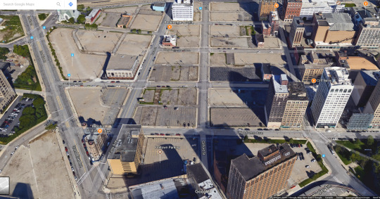
The whole looks like any other American suburban community with the freeway skimming residential areas, the collector defining the neighbors, and then smaller roads extending everywhere until they meet all houses.

I wanted to plot an hypothetical visit of one neighbor to the other and this is the result. It’s a three miles trip by car that will take at least 9 minutes because there are no opening in the shape of a road or pedestrian path to connect the two points.

This is how it appears from top-down view with a series of semi-natural and artificial barriers that separates the cul de sac on the right with the curb on the right. Two worlds apart basically because of arcane and mysterious reasons that impelled urban designers to totally exclude any sort of travelling from one side of the neighbor to the other. Picture if the neighbor’s house is on fire and you want to help them escape death; you won’t probably because you either climb over the two fences and the trees, or you drive your car but that’ll take 9 minutes and who knows if people there are still alive by then.

Highlighted in red it’s the whole barrier of fence and trees that separate the neighbor in two distant sides, where socializing can be as difficult as Berlin in the 1950s between West and East.

To avoid your other neighbor doesn’t get the chance to invade you, the developers built an artificial canal (highlighted in blue) to furthermore make sure people don’t get together and come up with crazy ideas like socializing. In yellow the broken connection that might have been existed with a pedestrian path, but better not take any chance.

Here’s the site from another point of view and you can see how the whole portion doesn’t allow for people to walk or drive to the other side, splitting the pod into three areas.

I zoomed as much as I could and you can see it’s not just a road network issue anymore but a lack of safety feature that could help people stay away from danger. After all these are places where families with young kids live.
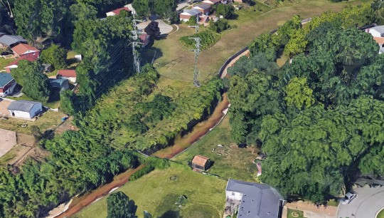

In yellow I highlighted the dangerous areas where the lack of fence around the power lines and the canal have allow for free access; anybody can go unrestricted near the pylons and the ditch. Unsupervised kids face the most peril especially when it’s right around their backyard. Coloured in magenta it’s what appears to be a narrow bridge but in fact is a floodgate connected by another fence to the little shack on the right.
Notice also the lack of sidewalks everywhere; this tells us a lot about the urban design of housing communities where the pedestrian was left out of the picture in the first place. People going for a walk have to be in the street increasing the risk of being struck by a vehicle, this shows us the very weak UX design home owners are affected, but also emergency vehicles who might get tangled driving streets which have been badly shaped.
What does this mean?- We live among cities that are the result of zoning laws which manufactured landscapes dictate by cars first and people second. In North America there’s nowhere a car couldn’t go from the driveway to the drive-through of your local burger joint; drive in movies for cars, parking lots eating away downtown portions of many cities, and many other issue which gets in the way of creating healthier places to live.
UX design is not only about websites and phone apps, it extend its dominion onto any other experience the user goes through that can be as simple as opening a pickle jar or driving to work. Both these elements engage people into specific and different behaviors which can result in the success of failure of products and services.

Detroit has been through decades of social and financial problems ever since the city slowly slumped into oblivion and collapsing on itself until bankruptcy. The auto industry fueled the city’s growth for many years starting at the beginning of the 20th century with the advent of the automobile.
Fast-forward to the 21st century and everything is gone from the city once thrived with the biggest industry of the West. But it wasn’t enough for Detroit as it gamble its entire economy on cars rather than diversifying the industry investing in different fields. By the time politicians realized that it was too late.
We can trace back how the city developed into something fit only for those having the ability to afford cars, while the rest of those who relied on walking were left out of the equation for good. Today Detroit still lags behind in having an effecting public transportation system to make a significant impact, but it’s very hard when the entire city was developed inside the car-culture.
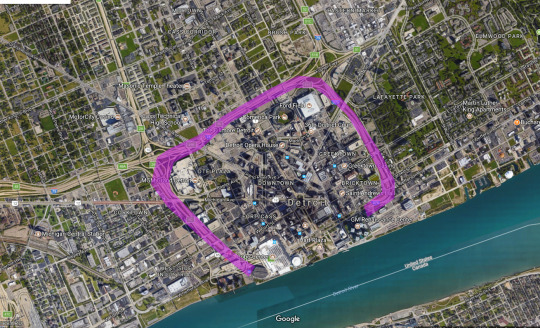
Three freeways isolate downtown from the rest transforming it in a citadel.
One of the main issues that affected the urban development and prevented the city from adopting a better road system, was the the layout of the freeway system that chokes downtown Detroit. The John C. Lodge, Fisher, and Chrysler freeways surround the urban center isolating it from the rest of the city.
Artificial barriers in the form of roads, ramps, collectors, are responsible for creating specific condition among neighbors, mostly negatively impacting hundreds of blocks at the time. Developers find this method very useful to separate high and low values housing so it won’t affect the pricing market, thus ensuring specific parts of town remain within a specific yield of profits.
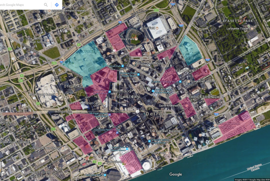
Another important issue is the large presence of parking lots surface downtown. Highlighted in red the volumes dedicated to car parking are spread out comprising a large portion of the city core. Whenever cars have a place to be stored they will create incentive to use them everywhere as an extension of people’s lives that cannot be excluded.
The two portions in blue represent large areas of vacant lots that once hosted buildings. Today they leave tremendous gaps between blocks that reminds of Berlin in 1946 after the rubble removal. Focusing on the site located on the top-left corner we can comprehend how much Detroit has been neglected.
The highlighted area has an approximate dimension of 176,900 square meters of vacancy (plus/minus the presence of some buildings).
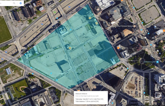
A close up of the area shows how depressing the area appears. Temporarily parking lots are placed where once buildings stood as there is no certainty of the urban plan for this area.
Uptown faces the same issues of large presence of parking areas that make up for a large potion of the space. The gargantuan suburb conveys tens of thousands of drivers every day requiring areas to leave their vehicles somewhere. Although commercial and public volumes required park spots for obvious reasons, they still represent a small percentage compare do the rest.

The red area represents the high-density portion of Detroit while the yellow one is low-density with suburban-type zones. This has been impacting the city for decades: everything revolves around vehicle ownership and those who don’t cannot rely on the weak public transport system or downtown residency.
Crime and high rents have pushed people away from the high-density areas towards the suburbs. Downtown is a corporate fortress that is ‘protected’ by a ring of freeways which doesn’t allow for a smooth transition towards the fringes.
The sprawl of Detroit -like many American metropolis- has impacted the life style of many citizens who are subjugated to the condition their neighbors dwell. In the last 20 years the city has suffered from crime sprees, major city corruption, financial collapse.
To build and to maintain such enormous suburbs required billions of dollars that cannot be made back in tax revenues: low-density neighbors don’t yield enough property taxes. The city was lost with a 20 billion dollar budget gap in 2013 after declaring bankruptcy.
The only way for Detroit to swamp itself out is to drastically rethink its urban design by reshaping vacant lots and abandoned neighbors. Building hi-density zone with enough green and public surface will create a major investment for the future.
At the same time public transportation must be made bigger than it is today, so streetcars and buses will have to increase in fleet size and stop network to provide access to everybody from the city fringes to downtown.
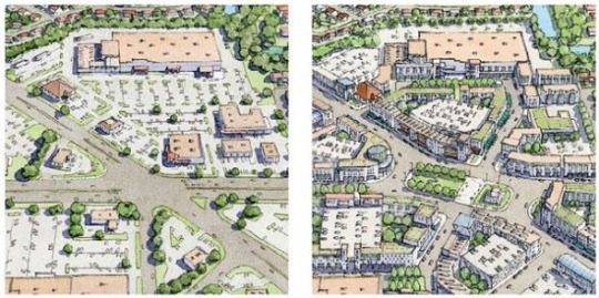
Illustration by Galina Tachieva repairing the sprawl.
Retrofitting neighbors has the best ability to render any city a place worth caring for. Once dead malls and flat surfaces are reborn building gracious communities and promoting pedestrian activity, then everything can become precious again . Areas that are well lit and offer rich patterns in their design will always engage the eye placing more importance in its care and existence.
Detroit can surely use what New Urbanism has done to other cities by reclaiming unused volumes and structures to increase their values by tailoring places around people first and cars second. Redeveloping city blocks opens for new opportunities of business and residential units for mixed using, departing from the old concept of leaving the housing pod with the car just to make small purchases.

I’ve written about housing problems, solutions, and the need to address the sprawling issue that is affecting North America under many ways. We know there’s a crisis affecting millions of people which are pushing for a way of life which is not fully compatible with the environment.
Tiny homes have been on the feed of many social platforms for the past ten years displaying how cool they are, how cheap they can be made for people to purchase with their minimal requirements.
After a lengthy look through the years of this trend in small homes, we can say that without any effort it’s financially logical to dive into an investment of such dimension: on the wheel, cozy, made of natural elements, cheap, and so on.
I find myself arguing against this type of living for the simple reason that it represents the most essential condensation of individualism. They are no different than renting a single room in a house, except your isolation increases because you have the ability to pull it wherever you like it if you opted for the wheel option.

Some have different shapes, some look like the Sandcrawler from Star Wars.
Tiny homes are here to represent an extreme side of housing solution, yet they claim to resolve the many issues of urban sprawling. Their volume of less than 500 sg/ft -on wheel sometimes- is now a trend among architecture and design platforms, but they represent a phenomena of hyped iconoclastic reality juxtaposing against any other viable solution.
Why do we drift from gargantuan McMansion volumes to micro living spaces?- One of the reason is the hype of existentialism in reducing everything to the bone which has been affecting modern society today. It comes as an almost natural response to the exaggeration. The other bit is the will of people to remove themselves from the consumerism trap of their previous generation: millennials don’t want to repeat their parents mistakes and don’t want to end up living in the suburbs.

Some of these homes have great interiors and for a moment you forget they are the size of a shoe box. So fare this is not the solution to a housing crisis which tends to sprawl and consume so much capital and resources. Tiny homes are a trend and like all trends they tend to stay for a while and then fly away until the next one comes.
It’s a confining space that dehumanizes the persona and removes any sense of hospitality. Reducing the living space to a fancy VR or trailer might sound cool, but it’s far from being a home, it removes the very definition of human space becoming a display of self indulgence under the pretense of environmental caring.
Perhaps the real issue here is the lack of compromise between the 5000sq/ft mansion and the 500 sq/ft tiny home. There’s a lot that can be done to provide affordable homes and it should begin with the improvement of already-existing spaces, abandoned malls that can be turned into townhouses and have enough green space for people to enjoy. Cities have plenty of old sites that can be renewed, it’s just a matter of gearing up the right mentality.
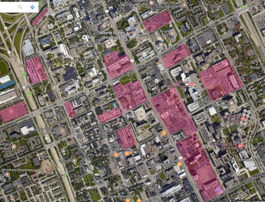
Sunday afternoon I decided to walk uptown Toronto on Yonge St. to reach the Kinkos shop so I could mass print a few documents. The weather was stable enough and it felt just right a stroll after lunch.
The whole corridor between Finch Ave. and Sheppard Ave. on Yonge has been a constant crescendo of high rise activities since 2000, between the realization of the purple subway line and the many Asian restaurants that replaced the old pubs and burger joints.
The apartment complexes running along the street are coasted by two large low-density residential areas to the west and to the east side, virtually shielding them from sight. Plenty of food from sushi to Korean bbq, from pharmacies to bubble tea shops, it’s a vibrant and young portion of town that will keep you busy if you are a foodie.
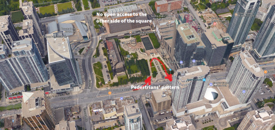
Mel Lastman’s Square is great for public events, but its positioning doesn’t attract people.
However, if you slow down and pay attention you will notice the lack of public spaces with the exception of Mel Lastman’s Square; the rest is sidewalks and a series of missed opportunities that would have given a better look and functionality to this part of town.
The square especially has a problem in terms of accessibility since it doesn’t generate pedestrian flow. People have their major entrance and exit point only from the Yonge St. side, leaving the back unattended for lack of opening. The place feels rushed in terms of design development, and the facts it has limited entry and sight doesn’t help.
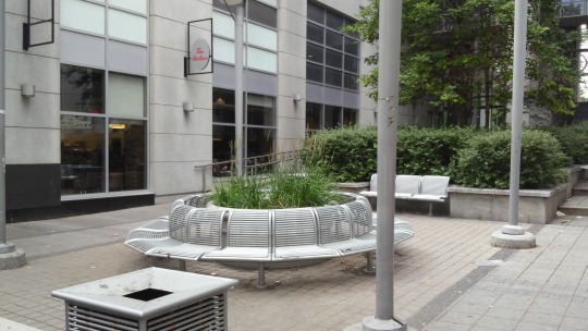
Squeezed between two towers, an attempt at public space suddenly appears.
I took a picture of a portion of space between two buildings that allegedly should work as public dominion, unfortunately it’s always empty and leads to nowhere but private property access. Indented areas don’t really work if there’s no accessibility from either side when built this way, pedestrian activity doesn’t happen because there’s no source of foot traffic transiting through.
This spot would have worked better if it featured a more welcoming sitting configuration and some flowers too, unfortunately it wasn’t well kept and weeds grew out of the large green container. The overwhelming use of metal elements to create this space make it feel cold and unwelcoming.
The Bauhaus nostalgia is strong with this one.
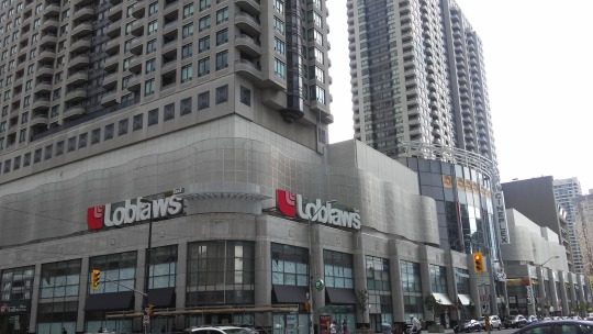
Close to the sitting area the North York Centre functions as shopping area for thousands of residents and visitors. Inside it hosts a cinema, a large grocery store, restaurants, health clinics, electronic shops, subway stop, and formerly a two-story Staples point which is now no more leaving a huge retail vacancy that removed the only bit of colour from its facade.
From outside the industrial look minimizes its appeal removing any human element form it. The lack of distinctive patterns and vegetation alienates the pedestrian from having a pleasant interaction with the place, also the absence of alternative space arrangement emphasizes the frenetic flow of people along the sidewalk: nowhere to stop, nowhere to sit, it’s not meant to have anyone gazing around or stopping to contemplate.
What punishes this urban setting is the verticality of Yong St. which left no options for an alternative design to happen; intersections are at right angles and leave no room for the public realm to properly exists. This pushes these areas to become sad enclaves of private spaces that oust the public from enjoying their towns.
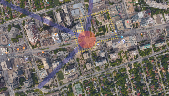
Diagonal, a missing term in the urban design manual of North America.
Alternatively, the design would have improved if roads took a different angle than crossing at 90 degrees with each other. The Spanish city of Barcelona is characterized by the Avinguda Diagonal, a large and important street which goes through the whole city without running parallel with other roads. Paris is another example of alternatives to the repetitive pattern of road grids that characterizes Canada and the US.
Diagonal street design has the ability to make cities feel more organic and less artificial, they allow for more sidewalk space to exist and therefore to grant access to more pedestrian traffic and business activity which can expand outdoor.
Above the aerial view of the portion of Yong St. and Mel Lastman’s square with an alternative design: purple lines represent additional roads that help relieving traffic directions, red is the focal point that connects all the streets, the dashed yellow line represents a much bigger possible public space pedestrians can enjoy and business to thrive.
The current setting of designing roads doesn’t allow for a natural flow of pedestrians, but rather a parallel dynamic dictated by the car traffic directions. This is one of the reasons these areas don’t collect as much people as they should. At random times through the day you can see the lack of people, the only instant they have activity is during lunch hour when office workers eat their meals in the square.

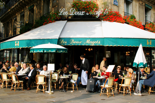
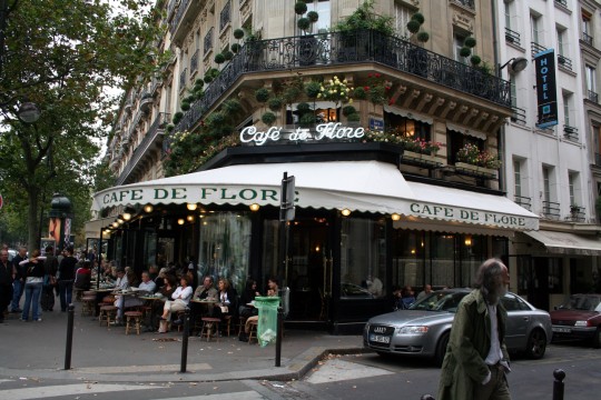
A cafe in Paris where outdoor seating is a must, even in the winter.
Intersections that meet at different angles have the ability to generate more sidewalk space for people to experience. Cafes in Paris flourished because of this road design which allows commercial activities to extend their seating capacities just outside their doors, becoming a staple reference point for citizens and for cities to become alive.
Bars and outdoor seating areas are greatly cherished and respected in Europe as they represent the quintessential experience of claiming the public space which rightfully belongs to the people. On the contrary, in North America, the systematic absence of the public realm has favored the car-culture to bloom uninterrupted, creating more harm than anything else to cities, pedestrians, and the environment.
The pleasant sight of people filling the streets and enjoying the public realm, a rarity in North America.
Why does this happen less frequently in Canada and the US?- It’s understandable how the weather of certain portions these two country experience has its own impact; however, the good season allows for metropolitan areas to have their share of pedestrians activity to fill the streets.
The current design of cities in these two countries developed around the Industrial Revolution period, where the need for mechanized transportation was already in place, so roads had to be able to host a large flow of private transportation which later transformed society with the advent of the car and the birth of the suburbs, thus more road lanes and less space for pedestrians.
All in all, cities never stop to change especially when we talk about Toronto, now the 4th largest metropolis in North America; so there are big shoes to fill from this perspective. Tourism can greatly benefit from extended pedestrian areas that concentrate people granting more time to be spent around business activity.
In the end we should rethink the way we perceive the public realm. Public as for pedestrian to use, not for cars to generate more traffic that already exists, so it’s essential for citizens to demand from their local and national political representatives to broaden their views in terms of environmental issues. It’s not just a matter of how many trees you plant, but how much space families and tourists can benefit from a better developed city.
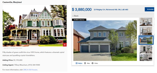
I just found two different listing on the internet as I was making market research for my essay on suburban spaces, writing about house prices and quality. My broad web search led me to find two architecture realities that demonstrate how the real estate landscape is odd and sometimes on steroids.
The house on the left is a beautiful Victorian home located in Maryland in the US, the asking price is US $1.19 million, while the one on the right is a McMansion outside Toronto going for CDN $3.8 million. What’s going on here?
The Canadian housing market is gone crazy with prices that aren’t stopping soaring not even through the crisis between 2007 and 2008. Toronto Listings are filled with small 2 bedrooms 1 bathroom going for 600k at least for homes built forty years ago.
Off course the two locations are geographically different and housing markets might follow alternative priorities; however, it’s shocking seeing how much value some new homes have reached despite their bland style and cheap construction material.

This other listing featured another beautiful home in Seattle with lake view and compared to the above house outside Toronto it still cheaper by $1 million and change. Despite the styles, this Victorian house has been built with far better quality than any multi-million dollar mansion in 2017, and it has retained its aesthetic value for over a century while newer homes won’t last fifty years.
Communities outside the city built with the principle of traditional craftsmanship in the 18th and early 20th century have contributed in making the urban landscape better looking. Essentially they make neighbors vibrant, original, and worth caring about. Today, instead, we face the sad reality of cookie-cutter homes built left and right non-stop with the cheapest materials which are too expensive and out of the reach of consumers and add no particular values to communities.

This is Saratoga Springs in the state of New York in early 1900. The coloured picture shows a specific period in time where pedestrian outnumbered in presence the carriages and cars. The space division between building to building it heavily emphasized by a generous sidewalk outlined by a series of tall and lush trees that carry along the road.
In recent times we have forgotten how important is a well designed road network. Systematically we removed many pedestrian features to favor cars and its culture. The realm of public life has been ruined by the pervasive ideology that cars are the solution to public life, and also to the transportation issue.
The phenomena of removing space from sidewalks and its features has transformed North American cities into speedways. If once we had more square surface for feet, now we have more than that for rubber. All this has developed by leaving the public transportation out of the equation and pushing the notion that commuting is the way to be.
The essence of the public space extending from the edge of buildings towards the road, is the pedestrian domain of social activities which makes the urban landscape vibrant and acceptable. Without it we would give up our very own ability to claim public spaces a human experience.
The sidewalk becomes an opportunity for business to thrive and for the public to experience a better urban life by walking their neighbors.
Today we have seen the drastic changes of our cities in favor of a chaotic systems that pushes for cars to be the main feature of urbanism. As the invention of the car made its way worldwide, we slowly reduced the public spaces to a mere sequence of tarmac junctions for traffic to collect in it.
The functionality of a wide sidewalk to host plenty of people, along with a solid sequence of trees, has been proven to work pretty well in terms of urban design. As the road traffic flows along streets, the parallel parking creates a virtual barer to define the obstacles along the road in order to protect the pedestrians.
Wide sidewalks aren’t just for people to stroll by, but they provide opportunities for local business to become part of the community establishing their brand and practices. Bars, restaurants, cafes, are all in need of public pedestrian space to engage people into enjoying the city.
At the same time a solid line of tall trees enforces the safety boundary between the street and the sidewalk, while simultaneously the branches with their leaves provide the necessary shade to cool the ground and preventing excessive heat from creating heat bubbles across the city.
The trees coasting the streets will absorb the CO2 produced by vehicles and release at night the fresh oxygen, which replenish the air quality of the city. This will help the overall urban temperature from producing excessive heats during summer periods.
Trees along roads will work beyond their natural purpose. We forgot how the presence of green throughout cities has the ability to remove the grey effect of buildings, and to create a welcoming atmosphere through communities, enhancing the psychological aspect of citizens.
Municipalities ought to reconsider the way green spaces are used. Trees, bushes, and others natural elements can increase the life quality of many urban dwelling. Reshaping public spaces for pedestrians can only have positive impacts, engaging people into becoming more active among city streets while reconsidering their approach with the car.
Parks and vegetation spread out across cities works towards creating a wide and positive sense of urban beautification, which aims at defeating the grey and obsolete polluted stereotypes city dwells into. Municipalities can only benefit from implementing such natural spaces that focus on pedestrians to reclaim space from cars; also by reshaping the old concept of suburban solumes that are virtually isolated from any walking experience or commercial engagement.


Moscow is the capital and largest city in Russia with 12.2 million residents. The city is organized into five concentric transportation rings that surround the Kremlin. The two innermost rings are seen here.
55°45′N 37°37′E
Instagram:http://bit.ly/1VI7EwZ
Source imagery: DigitalGlobe
Post link

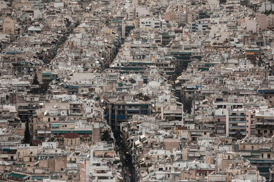
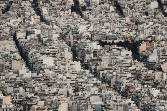
Margarita Nikitaki Takes Claustrophobic Photographs Of Athens’ Cityscapes
Soil by Greek-Japanese photographer Margarita Yoko Nikitaki is a photographic project shot in Athens, Greece’s capital city. Margarita reached the top of Athens’ hills to observe the city as she looked for ideas on how to visualize the effects of human intervention.
“In the images we see a series of condensed, homogeneous and grey stacks of constructions, streets and city blocks that seem to be colliding with each other into a mass devoid of a horizon,” Margarita explains. “The pictures show the extensive densification of the Athenian cityscape that has been taking place over the last 100 years. What the images don’t show is that Athens is actually surrounded by four large mountains and several hills, but at ground level the bare soil has been replaced by cement, and the horizon has been replaced by the urban skyline.”
Source:Design You Trust
Post link


The immense graffiti of the abandoned Miami Marine Stadium in Florida. Abandoned after Hurricane Andrew in 1992.
More —> http://www.abandonedplaygrounds.com/the-abandoned-giant-graffiti-paradise-of-miami-marine-stadium/
Post link

Iidabashi Station (Chiyoda-ku, Tokyo)")
Iidabashi Station (Chiyoda-ku, Tokyo)")
Iidabashi Station (Chiyoda-ku, Tokyo)")
Iidabashi Station (Chiyoda-ku, Tokyo)")
Iidabashi Station (Chiyoda-ku, Tokyo)")


Minimalist Industrial Table
Raw steel with treated skin, barn-reclaimed Hemlock beams, half-inch glass
84x42 inches ; Italian structural styling, references to Shinto gates in wood overhangs
Post link


Liberland could become the world’s first algae-powered city
Back in 2015, a group of disillusioned Czech citizens had this idea that they would secede from the nation and form their own sovereign state: the Republic of Liberland. The small 2.7 square mile site lies between Croatia and Serbia, right over a flood plain of the river Danube.
Several thousand people have since applied for citizenship in the tiny nation, with proposals for the design of the state open to those who dared submit a proposal. In the end it was RAW-NYC who came up with the winning idea; a stacked city of self-sustained blocks would gradually build upwards and outwards from an initial set in what the designers call “Inverted Archeology”.
The city would be pedestrian-friendly, and the unique stacked design would allow for buildings to be placed much closer together than traditional construction would allow. Buildings would be like skyscrapers put on their sides; built in layers and accessible to everyone at all levels rather than simply at the ground lobby as traditional towers would be. These would also be meticulously planned to allow natural light to penetrate all accessible spaces.
To mitigate greenhouse gases created by such a dense urban environment, algae strains that do not require sunlight to grow would be housed on the undersides of the buildings in a vast underground habitat; providing clean energy.
See more at: Inhabitat
Post link

Kranhaus, Cologne, Germany

Athena Tacha, 33 Rhythms (Homage to the Cyclades), 1977

Paolo Soleri, Hexahedron, 1970


5/03/2021 I took a break from social media after such a busy month I had to reduce my phone usage, hence the disappearance! I’m currently making maps for my Urban Design: Place Making module and its kind of lonely work, so I’ve made some new spotify playlists to get through it. Hope everyone had a nice February - the lockdown was getting quite hard for me! x Emily
Post link


District//S
Allies and Morrison Architects were awarded the Francis Tibbalds Prize for best Practice Project at the National Urban Design Awards in 2013 for this project in Beirut.
The scale and distribution of the 22 buildings is well thought out, creating a network of pedestrianized public spaces.
Photos via Allies and Morrison Architects
Post link


You may remember a while ago I had written about a development at 1 William St in Brisbane.
Well, this week 2 designs were revealed for an area known as Queens Wharf, located next to 1 William St (see pictures above).
This site constitutes 10 percent of Brisbane’s CBD. From an initial shortlist of four EOI proponents, two consortia entered the request for detailed proposals for an integrated resort development.
Before looking critically at the designs themselves, what have the consortia been asked to deliver?
The Queensland Government website for the Queens Wharf development describes its vision for the precinct as follows:
“A unique and vibrant new world city development that attracts visitors and investment, reconnects the activity of the Brisbane city centre to the river, preserves and celebrates Brisbane’s heritage, and delivers high quality public spaces.”
Precinct objectives
Queen’s Wharf Brisbane will:
- become an internationally-recognised precinct with world class sustainable urban design and architecture that establishes a clear identity that is uniquely ‘Brisbane’ and 'Queensland’;
- stimulate broad investment and economic development in the long-term future of Brisbane as a New World City, focusing on tourism and construction;
- redefine public access and transport connections into, through and around the Brisbane city centre - from bridge to bridge and river to ridge;
- transform and activate places and spaces that draw people to the origin of Brisbane as a city; and
- promote social interaction and a broad range of urban activities from the city centre down to the river’s edge.
Honestly, I don’t know enough about the economics of the city to comment as to whether or not Brisbane’s CBD needs an integrated resort development, but clearly development of this site is driven by economics.
As for the design itself and with consideration to the precinct’s objectives, I think both designs are grossly out of scale, with neither design stepping down towards the riverfront. There doesn’t appear to be anything that establishes a clear identity that is uniquely 'Brisbane’ or “Queensland’, nothing that relates to a subtropical climate; these buildings could be rendered into any number of city skylines. Admittedly I am only going off the few images released, but the designs do not appear to create vistas towards the river, but block them. I am also concerned about the shadows these towers are going to create and how the designs connect and respond to the existing buildings. Neither design appears to deal with the bordering freeway that currently cuts off access to the river, which is a missed opportunity for some interesting / innovative design. Both designs propose bridges across the river, which I’m sure can be used to argue redefines public access as noted in the precinct objectives, and yes, it can be argued that both designs promote social interaction. Overall, I’m pretty disappointed. I could understand if this was a design for the Gold Coast, but Brisbane’s CBD? My preference for spending time on the the other side of the Brisbane River remains.
Post link

- the Right to the City in the 21st Century. Are citizens losing their rights to corporations?
-Future Cities, an Australian perspective
- London School of Economics' 3C model for growth: compact, connected and coordinated
- Are policy makers promoters of gentrification?
- Playful urban spaces, lessons from Bilbao
Imagehere.

