#yeghistory

Words by Adriana A. Davies, February 2022
Artworks by Marlena Wyman February 2022
Artists-in-Residence at Yorath House
(Photographs as credited)
It is time to write the final blog post, No. 8, which focuses on family. It’s hard to believe that our two-month residency is up. It’s been an amazing experience and has resulted in a surge of creativity for Marlena and myself.
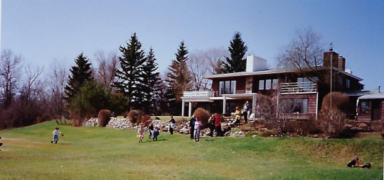
Yorath House ca 1980s. Yorath family collection.
Yorath House was a family home for 43 years and was a passive observer of all the joys, hopes and sufferings of the people who lived there. To understand this, I’ve done a lot of research on key family members. This started with revisiting the work on Christopher James Yorath, Dennis’ father that I did for his entry in the Dictionary of Canadian Biography, which I began in 2013. The family entrusted me with biographical accounts, correspondence, a memoir, newspaper clippings, speeches and other materials about C. J. but also touching on other family members.
Among these treasures was a small watercolour sketch of Yorath House done by a member of the team at Rule Wynn and Rule. Little did I know at the time that my attention would be focused on the house and that I would be a “resident” there for two months in 2022 (at least during the day). It seemed natural for me, therefore, to spend part of the residency focusing on the Yorath-Wilkin families and their experiences. This spun off naturally from one of the goals of our residency, which was to examine the relationship between space and place, and also time and the river.
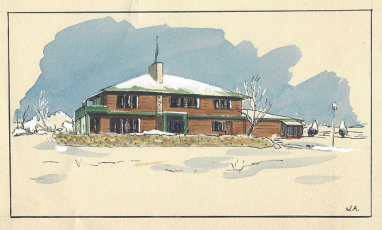
Architectural drawing of Yorath House by Rule, Wynn & Rule, 1949. Yorath family collection
In this respect, the experiences of the families are both unique and universal. Historic structures are not just about the design and building materials but rather about these and also the occupants who lived or worked there. The range of human experience, I believe, somehow leaves a residue in the walls and natural landscapes. I know that this is a fanciful and, to some, an absurd notion but, humour me, visual artists and writers get to play with this kind of stuff! I think that I can be both rational and fanciful as I move between non-fiction and creative non-fiction. I propose to tell some family stories in both prose and poetry, and show that human beings turn space into place.
The Yoraths: Father and Son
C. J. (Christopher James) and D. K. (Dennis Kestell) Yorath, father and son, were skilled businessmen and “community builders.” They were part of the industrialization and urbanization of the City of Edmonton and Province of Alberta in the twentieth century. C. J. was born in 1870 in Cardiff, Wales, the son of William Yorath and Sarah Hopkins. In 1904, he married Emily Kestell.i The couple had two sons, Dennis and Eric, and a daughter, Joyce. From 1895 to 1898, he studied civil engineering at Cardiff College (later part of the University of Wales). When he completed his studies, he obtained work with the City of Cardiff and learned a great deal on the job about issues such as drainage, street-railway electrification, road and bridge building, and artificial gas delivery. In 1909, he moved to London and did some lecturing at the Westminster Technical Institute and, more significantly, worked for the firm of Sir Alexander Richardson Binnie on a massive drainage project in the city. At that time, many ambitious young men looked to the colonies to further their careers. In 1912, he became aware of a major urban planning project: Canberra had been designated the capital of Australia. He submitted an application to develop the master plan; he was unsuccessful and then turned his eyes to Canada.
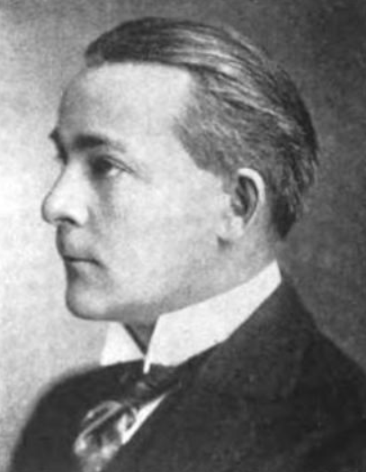
C. J. Yorath, Who’s Who in Canada, volume 16, 1922, page 748.
In 1913, C. J. submitted an application to an international competition to become city commissioner and treasurer for the City of Saskatoon and won. He may have learned of the competition from his brother Arthur, who had homesteaded near Oyen, a town in east-central Alberta, near the Saskatchewan border and north of Medicine Hat beginning in 1911.i C. J. was charged with preventing the City from declaring bankruptcy – the state of many Canadian municipalities at that time as a result of the worldwide recession and a dramatic fall in the value of land and property, and huge decline in the property tax base. On April 23, Yorath sailed from Southampton, England, on theOlympic (a sister ship of the Titanic) with wife, Emily, and their two sons Dennis and Eric. They arrived in New York on the 30th and reached Saskatoon early the following month.
C. J. brought not only engineering and project management expertise to his job but also a vision about the proper layout and development of urban areas. In a 1913 article that he wrote for Western Municipal News, he approvingly quotes Aristotle’s definition of a city as a “place where men live a common life for a noble end”; stresses that municipalities should be purposefully planned; and laments that too often “cities have grown up in a haphazard manner, and many a beautiful spot turned into an ugly accumulation of bricks and mortar.” Emphasizing natural beauty and artistic symmetry, Yorath allied himself with the Garden City movement, describing the ideal municipality as “beautiful, well planted and finely laid out, known and characterized by the charm and amenities which it can offer to those who seek a residence or dwelling removed from the turmoil, stress and discomforts of a manufacturing district.” He not only got the City out of debt, he also left them with a “Preliminary plan of greater Saskatoon,” which made tangible his vision of a city with plentiful green space and, among other innovations, a ring road around its outskirts. While it was shelved for lack of funding, as was the case in many municipalities across the country at the time, it was a legacy.
In 1921, he accepted a higher-paying job in Edmonton and, on March 23, the Edmonton Journal, welcomed him to the city and noted, “There are no airs of the autocrat or supposed superman about him.” He had a very large mandate: he was commissioner of public works and utilities and joint commissioner of finance, in effect, Edmonton’s city commissioner. C. J. found that the municipal debt was higher than that of most western cities and, during his three years in Edmonton, succeeded in putting the city in a stronger financial position. While more than a third of Edmonton’s debt was tied to its waterworks, electrical powerhouse, street railway, and telephone system, under his tenure all of these services were financially self-sufficient and provided additional tax revenue. Newspaper articles reveal that he was a popular speaker and visited other municipalities; a favourite topic was “public ownership vs. private control.” He was a strong believer in the latter.
Edmonton City Council minutes during C. J.’s term frequently deal with discussions about the provision of gas to residential and business customers. In 1909, Eugene Coste, who worked for the Geological Survey of Canada, made a major gas discovery in the Bow Island area near Calgary. He established Canadian Western Natural Gas in 1911 and built a pipeline to Calgary. In 1924, C. J. joined the company and, in 1925, became President and managing director of Canadian Western Natural Gas, Light, Heat and Power Company, which supplied not only Calgary and Lethbridge but also towns in between.i By 1927, Northwestern Utilities and Canadian Western had become subsidiaries of the International Utilities Corporation, an American holding company, and by 1930, Yorath was president and managing director of several other Canadian subsidiaries.
In June of that year, he arranged the sale of all these firms to the Dominion Gas and Electric Company, an American subsidiary. After this massive deal (the Calgary Albertan estimated its value at $30 million or $505,056,287 Cdn today) was completed, C. J. remained in charge. He was at the peak of his career when he died as a result of a heart condition on April 2, 1932. Family members believe that it was the stress of his work that precipitated his health issues. His obituary in theAlbertan encompassed nearly an entire page and outlined his business successes, as well as his community service, noting: “But the heavy burden of business cares did not curtail Mr. Yorath’s interest in sport and community life. He was a prominent member of the Kiwanis Club and a keen golfer, having been a member of Calgary Golf and Country Club for many years.” He was also a member of the Masonic Order, as were most members of the British establishment, and was interested “in conservation of the gas supply.” The article notes: “He had just returned from Edmonton, where discussions regarding conservation measures took place, when he was stricken with the illness which proved fatal.”i The work that he set in motion would result in the establishment of the Petroleum and Natural Gas Conservation Board in 1938 (later the Alberta Energy Conservation Board).
C. J. was part of Calgary’s business elite and the family’s home at 1213 Prospect Avenue in the Mount Royal district was an enormous brick and wood Craftsman-style home with some Tudor elements built in 1912. The district was initially nicknamed “American Hill” because of the number of wealthy Americans who lived there (this was pegged at about one-third). Some were initially drawn by the ranching opportunities and others by the coming in of the Turner Valley oil field in 1914. The formal photograph of the house in the bottom lower right corner shows the gas fittings in the home to demonstrate the importance of the fuel in a modern residence. The house was similar to the one built by Eugene Coste for his own residence, in 1913, which had 28 rooms and was located at 2208 Amherst Street in Mount Royal. As the district name suggests, the subdivision was built on an escarpment that provided expansive views of the new city. Like Old Glenora in Edmonton, there was a covenant that directed that only homes of a certain (high) value be built there. C. J.’s granddaughters remember the extensive grounds that surrounded it including gardens and flowerbeds and also allowed horses to be kept on the property.
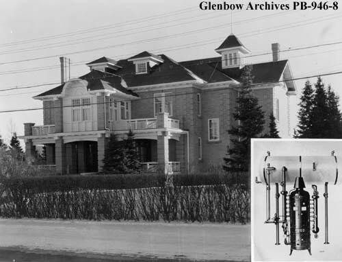
C. J. Yorath residence, Calgary, Alberta, ca. 1930. C.J. was President and Managing Director of the Calgary Gas Company. A sketch of the plumbing and heating system appears in the lower right-hand corner. Photographer: W. J. Oliver. Glenbow Archives, Libraries and Cultural Resources Digital Collections, University of Calgary, PB-946-8.
Dennis Kestell Yorath was born in London, England in 1905 and was educated in London, Saskatoon and perhaps Edmonton. His father’s wealth allowed him, as a young man, to enjoy the benefits of being part of Calgary’s elite and he learned to fly a plane and play polo. A number of young Canadian men had learned to fly during the First World War, among them Calgary’s Captain Fred McCall and Edmonton’s Wilfrid “Wop” May. They were pioneers who helped to set up flying clubs in their communities. Dennis knew both of them and was a charter member of the Calgary Flying Club, which was established in 1927, and obtained a pilot’s license in 1929.i He was also an expert horseman and played polo; in fact, according to his daughters, he played in a game with the Prince of Wales, Edward VIII, when he visited Calgary in the 1920s. According to newspaper accounts, he played for the Calgary Blues Polo Team among whose members was J. B. Cross. His father, A. E. Cross, was a rancher and co-founder of the Calgary Stampede, the Calgary Brewing and Malting Company, and Calgary Petroleum Products (1912). J. B. and Dennis would follow in their father’s footsteps. The pages of the family’s photo albums include pictures demonstrating these pursuits.
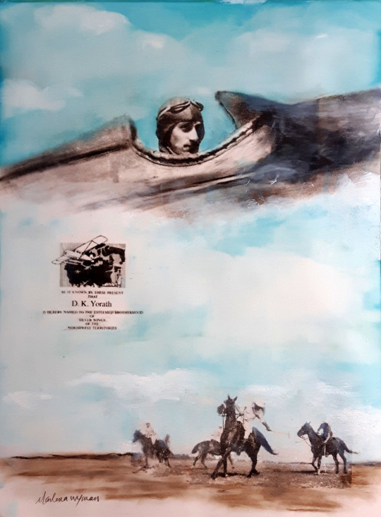
Dennis Yorath painting by Marlena Wyman – image transfer and oil stick on Mylar. (Photos from Yorath family collection ca 1930).
With respect to his career, Dennis started work with the Imperial Bank of Canada in Edmonton where he worked for two years and, then, following his Father to Calgary began work, at the age of 19, for Northwestern Utilities and, in 1925, for Canadian Western Natural Gas. His father’s early death at the age of 52 catapulted him into a leadership position in the companies. In 1933, he married Bette Wilkin, whose father, among his various real estate and insurance interests, was also a co-founder and shareholder of the North West Brewing Company. According to family history, the Wilkin and Yorath families knew each other when C. J. and wife Emily lived in Edmonton, and that Dennis dated Bette’s older sister Jean until she found the man she was to marry. Dennis then turned his attention to Bette. After their society wedding, the couple went on an extended honeymoon to China and Japan, and brought back some lovely antiques including a Chinese chest, Japanese screen and brass inlaid tray table and two stools. They moved into a cottage on the grounds of C. J.’s home in Mount Royal. In 1940, Dennis left his jobs to serve his country becoming director of pilot training for southern Alberta, based at the No. 5 Elementary Flight Training School near Lethbridge as part of the British Commonwealth Air Training Plan.i In 1941, the School relocated to High River. Bette and their two daughters, Gillian (born 1936) and Jocelyn (born 1938) remained in Calgary. Just as his father’s career had been impacted by an oil and gas boom, so would Dennis’ career. The coming in of the Leduc and Redwater fields, in 1947 and 1948, triggered massive development, and prosperity for not only Edmonton but also the entire Province of Alberta. In 1949, Dennis was transferred to Edmonton to become general manager of Northwestern Utilities and, in 1956, became president of both Northwestern and Canadian Western Natural Gas. He served as chair of both from 1962 to 1969. From 1957 to 1973, he served as Director of the International Utilities Corporation and, from 1973 to 1981, as vice chair of International Utilities Corporation. On March 2, 1971, the New York Times noted: “TORONTO, March 1 (Canadian Press) – The International Utilities Corporation reported yesterday that its 1970 net income rose to $33,475,000 [worth $242, 562, 610 Cdn in 2022], or $2.42 a share, from $33,070,000, or $2.61 a share, a year ago. The Toronto-based conglomerate, which has administrative offices in Philadelphia, reports its financial results in United States currency.”i
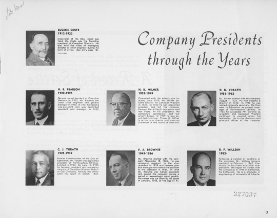
Dennis Yorath headed the Canadian Western Natural Gas Company when it celebrated its fiftieth anniversary. A commemorative book titled Half a Century of Service: 1912 – 1962: Canadian Western Natural Gas Company included photos of its presidents on page 3.
On their move to Edmonton, Dennis and Bette chose to build a “signature” house in the Modern Style designed by Rule Wynn and Rule, just as his parents had chosen a Craftsman-Style House in Calgary. Dennis died on May 8, 1981 as a result of early onset Alzheimers’ Disease. In 1985, Bette had her nephew, architect Richard Wilkin, design and see to the renovations required to create a rental suite on the second-storey of her home to avoid living alone. In 1992, the city bought the 11-acre Yorath property for $900,000 to consolidate public ownership of river frontage in Buena Vista Park. The fieldstone memorial at the river’s edge of the property commemorates not only Dennis and Bette but also her parents, William and Hilda Wilkin, who had given them the land.
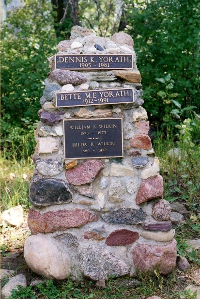
Wilkin-Yorath family cairn on the grounds of Yorath House. Yorath family collection.
During his lifetime, Dennis received many honours and was an active volunteer in both professional associations and community organizations. For his war-time service, he was awarded an Order of the British Empire by the British government in 1946. From 1947 to 1949, he served as the president of the Royal Canadian Flying Clubs Association, and, in 1949, was awarded the McKee Trans-Canada Trophy for his contributions to aviation. From 1947 to 1955, he was Director of the Canadian Gas Association (CGA) and served as Vice President in 1951, and, President, in 1953. From 1955 to 1957, he was a director of the American Gas Association. In 1951, he received a life membership in the Edmonton Flying Club and, in 1973, was inducted into the Alberta Aviation Hall of Fame. In 1955, he was president of the Edmonton Chamber of Commerce and, in 1962, headed the United Community Fund of Greater Edmonton. From 1966 to 1972, he served on the Board of Governors of the University of Alberta and was involved with the Friends of the University of Alberta Botanical Gardens; the University awarded him an Honorary Doctor of Laws Degree in 1974. Dennis was active with the Canadian Council of Christians and Jews, the Community Chest Air Cadet League of Canada, Boy Scouts Association and the Salvation Army. He was a supporter of the Edmonton Klondike Days Association and, in 1966, as part of the Sourdough Raft Race, six boats raced from the dock below Yorath House down the North Saskatchewan River. He was a member of the Committee that helped to decide on the design of the Canadian flag. He died on May 8, 1981 in Edmonton.
Mothers and Daughters
The women of the Wilkin and Yorath families lived in a time when they were defined by what their husbands did, and were expected to be excellent wives, mothers and hostesses. This was certainly true for Hilda Wilkin, Emily Yorath and Bette Yorath. Their husbands worked hard and the families were part of the upper middle class elite of people of Eastern-Canadian, British or American origin who dominated the development of Edmonton and other communities not only in Alberta but also the rest of Canada. Their doings can be found in the pages of the Edmonton Bulletin, Edmonton Journal,Calgary AlbertanandCalgary Herald. Their attendance at events at the Legislature, church fetes and meetings of the Imperial Order Daughters of the Empire, St. John’s Ambulance and other patriotic societies always referenced them as “Mrs.” or “Miss.” Their first names were rarely mentioned, if at all. They are invisible except in the many pictures in family albums.
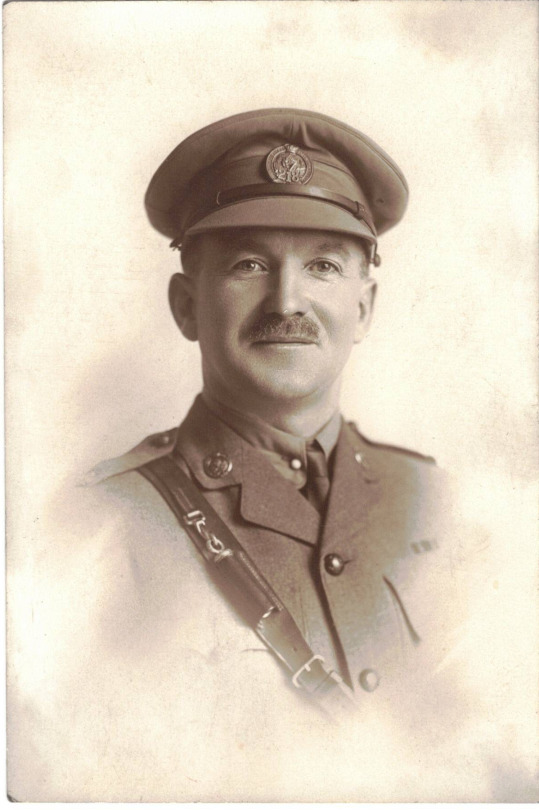
William Lewis Wilkin in military uniform, 218th Battalion, Canadian Expeditionary Force, ca. 1916. Photo courtesy of Richard Wilkin.
William Lewis Wilkin arrived in Edmonton in 1892 on an adventure and began to make good working at retail, real estate and insurance brokerage. He returned to England in 1904 to marry a childhood friend, Hilda Richardson Carter, and brought her back to the relative wilds of Fort Saskatchewan where he operated a store and served on the town council. Their first child, a son, also called William, was born in 1905, and their fortune improved with the increase in numbers of their family. As property ventures began to dominate William’s business life, he and Hilda decided to move to Edmonton from Fort Saskatchewan. They auctioned their furniture so that they could have a fresh start and also went to England for a holiday with children Bill and Jean. This was not a “steerage voyage” and he writes in his memoir: “The trip over was as far as I remember very nice but not startling. On the boat Bill & Jean (about 4 & 2) shared our nice fairly large cabin at night & had meals & play room in the nursery which was well equipped with everything including a competent nurse.”
Hilda Wilkin (née Richardson Carter) and son W. V. (Bill). Yorath family collection.
Their Edmonton home was located on the corner of 123 Street and 103 Avenue and was a three-storey Craftsman-style home with a wrap-around porch. It was across the street from Robertson Presbyterian Church (Robertson-Wesley United Church today), which was built in 1913, and kitty-corner from the Buena Vista Apartments. Children Margaret Elizabeth (Bette) (born 1912), Robert (born 1914) and Richard (born 1919) completed the family. Their comfortable family home was known for excellent hospitality and, according to grandson, Richard Wilkin, almost every evening his grandparents were “at home” for visits from family and friends. This continued in their new home at Connaught Drive in Old Glenora, which was built around 1945. Both Hilda and William lived to the age of 97 and welcomed grandchildren into their home and even hosted sleep-overs. Their homes were tastefully decorated with English antiques and they adhered to the formalities and civilities of British life with teas and formal Sunday dinners.
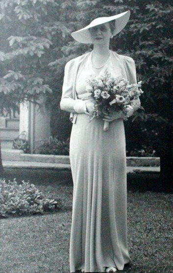
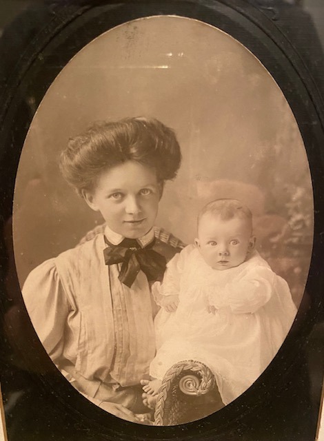
Emily “Marnie” Yorath (née Kestell) pictured in formal dress for a wedding or other society event. Yorath family collection.
Emily Kestell Yorath was the perfect hostess for her husband, a leader of the business community, and presided at events in Calgary at their Mount Royal home. The Yorath children – Dennis, Eric and Joyce – all married well and had children. The Yorath children called their grandmother “Marnie.” There was always something to do both inside and outside the grand home. There were extensive gardens as well as games such as tennis and lawn bowling as well as horseback riding. The Yorath children and their spouses took part in not only family events but also other more official entertainments. After her husband’s death, Emily remained in Calgary where her daughter Joyce Yorath Williams and son Eric resided. Eric was vice president of Carlile and McCarthy Ltd., a firm of stockbrokers. Emily died in 1958.
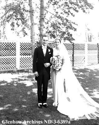
Dennis and Bette Yorath wedding photo taken in the garden of the Wilkin home in Edmonton in 1933. Photographer: McDermid Studio. Glenbow Archives, Libraries and Cultural Resources Digital Collections, University of Calgary, ND-3-6389a.
It could be said that Bette Wilkin “married up” but she was undaunted when she moved with Dennis to a modest home, referred to as a “cottage” on the grounds of the Mount Royal property. She had attended a private girl’s school in Vancouver for a time, according to her daughters, and was a superb equestrienne. The wedding photo of her in her parents’ garden in Edmonton shows a beautiful, self-assured and serene young woman. She was prepared to be the perfect wife, mother and hostess. Since Dennis’ father was dead, the oldest son and wife became the principal supports for his widow; and, since Dennis was in the same business, he continued his high-level social interactions with civic and provincial leaders, as well as the business community. Bette tended extensive gardens and bred peonies, rode daily and also raced thoroughbreds in “Powder Puff” Derbies in Calgary.
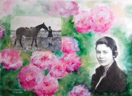
Bette Yorath (née Wilkin) painting by Marlena Wyman – image transfer and oil stick on Mylar. (Photos from Yorath family collection ca 1930).
Bette supported Dennis in all of his activities including the war-time work with the British Commonwealth Air Training Plan. She and her young daughters visited him in Lethbridge and High River where he was based. According to daughters, Gillian Brubaker (née Yorath) and Elizabeth Yorath-Welsh, the couple responded to the call from the Canadian government to help refugees and also befriended some Japanese Canadians interned and re-located to the sugar beet farming areas around Taber and Brooks. The move to Edmonton in 1949 was difficult but Bette took it in stride and with Dennis planned their new home working with architects Rule Wynn and Rule. The joy of the new home was extinguished when daughter Jocelyn died of leukemia in 1950. Sorrow was followed by joy with the birth of Elizabeth Jane. Life in Yorath House was a continuous round of socializing both with family and friends, and business associates and community leaders.
Bette’s taste was evident in the home’s furnishing which were a blend of antiques and contemporary furniture animated by purchases made on their honeymoon trip to China and Japan as well as other international travels. These included an inlaid brass tray coffee table and matching stools, a Chinese chest and Japanese screen. Bette also collected Japanese prints. The symptoms of early Alzheimer’s disease ended Dennis’ career but Bette supported him to the end. Four years’ after his death, she decided that she did not want to live alone and commissioned her nephew, architect Richard Wilkin, to design a self-contained suite to be created on the second-storey of her home. She died in 1991, the year before the City purchased her home.
Family Voices
In my work in community and social history, I’ve found that oral histories and correspondence, memoirs and other documents are an invaluable tool. The first-hand account is both exciting and revealing, and makes history come alive. Besides archival and other primary sources, I had the pleasure of talking with Yorath daughters Gillian and Elizabeth and nephew Richard Wilkin. I will let them speak in their own voices whether through transcripts of interviews or reminiscences.
Interview with Gillian Yorath Brubaker
Adriana A. Davies and Marlena Wyman
Zoom Conversation, Sunday, 3 pm Edmonton time and 1 pm Alaska time, January 30, 2022
After my parents’ marriage in Edmonton in 1933, they settled in Calgary where he worked. The family home, a “cottage” on the grounds of my grandparents’ large house, was situated near the Sarcee Reserve [Mount Royal] in Calgary. My father was an excellent rider from an early age and played polo including with Prince Edward on his visits to Calgary. One of his polo ponies, Cheetah, was brought up to Edmonton when the house in Buena Vista was built in 1949, in addition to our mother’s horse, Lady Patricia. We had more horses and donkeys in Calgary, but not all were moved up to Edmonton. Both my parents excelled at riding and my mother as a young woman had ridden as a jockey in “Powder Puff” derbies in Calgary and won! She had attended a private school in Vancouver for two years when in her teens. It was Crofton House School.i We rode almost daily and my sister Jocelyn was an excellent rider.
I believe that the Calgary cottage was built around 1920 and my parents bought it and moved in after their honeymoon in China and Japan. My grandparents lived in the “Big House” next door. My grandfather died in 1932 and my father followed in his footsteps working in the gas business in Calgary and later Edmonton (International Utilities).
My father was a skilled aviator who learned to fly in his early twenties. He would fly a Tiger Moth aircraft to our home in Calgary. He was a friend of First World War flying ace Wilfrid “Wop” May. From 1939 to 1945, my father lived in Lethbridge as head of the British Commonwealth Air Training Plan. He was very concerned about the air crews that he helped train and grieved at the loss of lives. He was away from the family and this was hard for me, my mother and Jocelyn, who was 14-months younger than me.
The nearby community of Taber was a centre of the sugar beet industry and was chosen as a location to intern Japanese from British Columbia, who were designated enemy aliens in the Second World War.i Our parents befriended two Japanese young women, Tammy and Ruby, from the internment camp. My parents also signed on to sponsor displaced persons: the Government of Canada was advertising for host families. They arranged for Eine Kranz from Riga, Latvia to come to Canada and my father located her fiancé Henry in a European internment camp and arranged for their wedding when they arrived. In Calgary, we had a huge garden and the Kranzs worked for us.
In Calgary, I attended St. Hilda’s School, which was a boarding school, and had to wear a uniform.i In 1949, when Father became the head of Northwestern Utilities, we moved to Edmonton and lived with my grandparents until our house was built. We moved in in the fall of 1949. Leaving Calgary was hard – I felt that I was losing all of my friends. I went to Glenora School in Edmonton at 135th Street and 102 Avenue (Stony Plain Road).i Jocelyn and I wore uniforms on the first day of school and we stuck out like sore thumbs. Jocelyn held my hand tightly and shivered. In the 1944 photograph of myself and Jocelyn with our cousin Rick Wilkin, we are wearing our school uniforms and Rick was wearing a robe. The photo was taken at the Wilkin summer place at Kapasiwin Beach on Lake Wabamun.
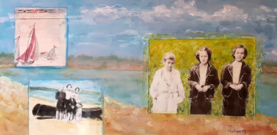
Wilkin and Yorath Cousins painting by Marlena Wyman – image transfer and acrylic paints on Mylar. (Photos from Yorath family collection ca 1944).
My mother loved the move to Edmonton since she was born and raised there and had family and friends there. It was a “huge move” with not only furniture but also horses and a pony being transported up. The current Yorath House parking lot was a pasture at the time and the Yorath horses as well as some belonging to our neighbours grazed there. There was a shed for the horses. Near the house was also a gravel pit and the Legroulx family lived nearby. There were three or four houses at the top of the hill. The Tellingtons also lived nearby, along the river.
Our house was built on about 14 acres of land and there was a mink farm owned by Esther Fisk nearby. It was 14 miles away from the City and located in wilderness. The house had many flower beds and also fruit trees around it. In Calgary, we also had large gardens including one devoted to peonies, which my mother bred and entered in competitions, some of which she won. She transplanted some of the peonies from Calgary into the Yorath House flower beds. The lawn and gardens sloped down on the land behind the house toward the river, and a large vegetable garden was planted on the side of the house where the garage is.
My parents had lots and lots of parties. Many had lost loved ones in the Second World War and just wanted to enjoy themselves. Cocktail parties took place all the time not only in our own house but also the Bill Wilkin residence [Richard’s family] at 16 St. George’s Crescent.
I remember breaking down when my sister Jocelyn died in 1950 and the first five years in the house I was in a daze. I remember that my parents were away and Jocelyn and I were staying with our Wilkin grandparents and sleeping in the same bed when Jocelyn woke me up and told me that she was not feeling well. I turned the light on and found the bed sheets covered in blood. Jocelyn had had a massive nose bleed. I called our grandparents and they took Jocelyn to hospital where she was diagnosed with leukemia. This was in September and she died in October [Provincial Archives death records show date as Oct 21, 1950]. I made a vow at that time to study radiology and go into nursing.
I attended Westglen High School [now an elementary school] at 10950 – 127 Street as did my cousin Richard Wilkin.i Initially I biked to school but eventually my parents bought me a blue Renault car, which I drove to the edge of the City, and parked on Stony Plain Road and 136 Street and walked the rest of the way. I remember that once while driving through the gravel pit near our house in my Renault, I nearly tipped it over. Baby Elizabeth was inside. We had a maid called Ilse who helped look after Elizabeth.
When I finished High School in 1954, I attended the University of Alberta and as a student worked for Dr. Bill Armstrong, who was a friend of the family. His specialty was ear, nose and throat. Around 1957, when I finished university, I went for a year of travel and work in Europe. I lived in London, England, and Linz, Austria. I remember climbing the Matterhorn and meeting my future husband John Brubaker on the climb. I climbed the West Ridge and he and a friend climbed the East Ridge. We then met in a bar. John was at Yale as an undergrad and attended law school in Charlottesville, Virginia.
In Linz, I worked in a Lutheran Church refugee camp that helped refugee boys who had been active in the Hungarian Revolution in 1956. They were kicked out of Hungary or maybe just left. I worked as a general “dog’s body” in the camp and was similar in age to the boys. Some of the boys went to Canada and established themselves. I returned to Canada but no-one seemed to be interested in my experiences other than mother and father.
John and I got married on December 28, 1959. The day was beautiful but cold and the well froze which meant that the inside toilets could not be flushed. Portable toilets were set up on the grounds. John and I flew to Calgary that night and then on to Washington, DC. There was a storm the next day and I heard that some of the guests from away stayed for three or four days adding to my parents’ worries.
John and I moved to Virginia and, then, in 1962, to Juneau, Alaska, and lived there until 1964 when we moved to Anchorage and we’ve been there ever since. I never went back to medicine and worked in a number of fields. John and I had two children, Heather and Michael.
I remember coming back to Edmonton for a visit in 1978 for the party that my parents hosted for Prince Philip. My son Michael was set to open the car door when the Prince arrived but the Prince opened it himself and said, “Beat you.” My parents knew a number of Royals.
With respect to the sale of our house, I remember that the City had “right of refusal.” I was shocked to see that the renovated house was so open and white on the ground floor. The downstairs was more closed in with “swing doors” into the dining room. There was also a door into the kitchen opposite the freezers on the wall. The dining room walls were pale blue and the floors throughout were teak.
Elizabeth Yorath-Welsh Reminiscences:
Part 1: Life at Yorath House
My parents moved up to Edmonton after World War 2 so my father could head up Northwestern Utilities. They built this house in 1949. The land was purchased from a farmer named Stephenson. The architects were Rule, Wynn and Rule.
I was born in 1951. My very early childhood of course is vague, but we did have maids until I was 2. Then there was a lady named Mrs. Bowman who looked after me when Mum & Dad would go away.
As a child I have very fond memories of growing up in the River Valley area now known as Buena Vista. There were quite a number of people living in that area along the river or overlooking the valley. Buena Vista road didn’t exist back then, so we used 81st Ave down the hill to 131st St. to get to our house, and it was all dirt/gravel road – awful after a heavy rain!
I remember Old Tom & his horse drawn wagon would come and cut the fields for the hay. He lived up above the zoo before it was built. Also, the milk was delivered by a horse wagon!
By age 2 I was getting to know how to get around rather quickly. Having the “run” of the river valley was not a bad life! There were other farms & small homes throughout the Valley, & the people were all wonderful. There was a chicken & turkey farm right across our field to the north owned by the Bates family. Both Sue & John Bates babysat me. Near them was my best friend, Heather Washburn & her brother, Rod. I would visit the Bates’ first, then carry on in time to watch Heather’s Mum braid her long red hair. Then we were off and running. This is all at ages 3, 4, & 5. The Washburns moved away when I was 6. I lost my dear friend to Vancouver!
At the area where Buena Vista Park begins, where the public washrooms now are, is where the Legroulx family lived. Larry & Jean & their 2 boys Claude & Marcel. Larry worked for my Dad both at Northwestern Utilities, & as a gardener & fix (nearly everything) man! Jean also helped out with a lot of the parties.
There were several mink farms around. One was owned by the Blaylocks on what is now 81 Ave at the bottom of the hill. That road used to go straight through until about 1970 when the city built the berm. Chris Blaylock was also a babysitter, & I played with his sister Lynne. Further up that 1st hill and to the right were several families, the Neimans. Kim was my age, & his sister Noanie also babysat me. The Shaws, who owned Shaw plumbing, had 4 boys & a girl. Actually one of the boys lives in the last house on Buena Vista beside the top end of the Zoo, Alan Shaw.
Laurier Heights School opened in 1958. By then a bunch of young families had moved into the Valley.
A wonderful couple lived across the field in a house that was beside the little hill that goes down to the parking for people going for walks. Esther & Ted Fisk & Ted’s brother, John. They had a few mink for a while, but then got rid of them to grow raspberries. Esther became our housekeeper & was a Nanny to me. A wonderful woman who taught me a lot! I would often have lunch at their house & tea after school. I will never forget going canvassing with her when I was about 5 or 6, & one of the houses we stopped at was Al Oeming’s. There in his back yard was this magnificent creature!! His Cheetah! Well … although a bit scared at first, I fell in love with Cheetahs!
I learned to ride with Betty Tellington who lived with her Mum & brother across from the big field where the dogs play in the off leash area. That used to be a horse field & riding ring. Betty had some great horses & I loved riding. We had some fun gymkhanas in the ring! I was not bad at the barrel racing! Betty was yet another babysitter as well. And her mother was my grade 6 teacher. There were several other small houses past the Tellingtons, and a large house at the end where the bridge to Hawrelak Park is now. I don’t remember much about them though.
In 1958 they were building Buena Vista Road to accommodate the opening of the Storyland Valley Zoo in 1959. Rather daunting to see those huge earth movers rumble down the road! But that changed things considerably. It soon became the new way to get to our house. And Laurier Park was built … which took care of the family of Métis that lived in the “woods” ½ way into the Park with their team of huskies tied up outside their shack.
Another shocker, there was a couple in the very early 50s until about 1956, who lived in the River Bank in a cave. I would not have believed it if I had not been in it! It was near where the Métis lived. I think Dad helped them out. It actually looked kinda cozy.
Before 1958 there were very few houses even up to where the IGA is now [not the IGA at 91 Avenue and 142 Street but another store that no longer exists near Laurier Heights School]. It used to be a Loblaws. And across from it was also small houses, shacks & farms. We bought our chicken eggs from a family who lived in a shack there. And, yes, shacks were common housing back then. I also remember our milk being delivered by a horse driven cart. We had well water until I was 9. Dad quickly got rid of it after my sister’s wedding in December 1959. The well froze the night before the wedding. A shock to wake up to. 150 guests coming to the reception & no water. Luckily, December 28th 1959 was a warm day. We were able to be outside around the fireplace. The caterers had to bring water in. The hairdresser had to come at 7 AM & bring hot water to wash Jill’s hair. She looked fabulous despite it all & it was a day to remember.
Across from where the Washburns & Bates had lived, a family from Holland moved in with their then 6 children. The Matthezings. A very good family. My father helped them over the 1st few years with getting city water, gas heating, & a proper fridge as I recall. The girls & I quickly became playmates. Liddy & I had a “club house” kind of a hole in the woods which is still there today.
Things began to change in the 60s & certainly in the ‘70s a lot of these places got bought up by the City Parks Dept. It has now become the Buena Vista off leash area we all know today. Thank God we hung on to this beautiful house my parents built, and it was declared a Historical Site so the public can now enjoy it today!
Reminiscence Part 2: Mum, Marnie & Granny
Marnie was my Dad’s mother. I remember her as being a lovely, warm, caring lady! She would come up to stay with us at least once a year, and shared my room. I also remember going to see her when we went to Calgary. Occasionally we stayed at her house & I always went in to see her in the mornings! Unfortunately she died when I was 5. She was staying with us when I got that spanking when Heather Washburn & I were caught playing by the river. She was very consoling, but also clear that Heather & I had made a wrong choice, that playing by the river could be dangerous. (So as you see, though Mum may have said something once, I learned the hard way that playing by the river was not a good plan).
Granny & Grandpose [Wilkin grandparents] were my favorites! I spent many weekends at their house on Connaught Dr. And the family often met there for drinks after work. Sunday dinners were also frequent. They were very patient with me, especially given I made a fort out of 2 card tables right in the middle of their living room! But I always helped out and cleaned up when asked. One big tradition was after Christmas Dinner we children were allowed to walk down the center of the dining table! Another Christmas Tradition was them coming out to our house to be there to open presents. I was not allowed to see the tree until they got there! Grandpose was gruff in a very amusing way … always teasing us. Granny would sometimes admonish him by saying “Tod, you’re scaring the poor child!” Later as I got older I learned a lot from Granny, especially cooking. I loved to bake with her & after finishing school it became apparent I was good at it & was sent to Cordon Bleu in London. Granny lived to be 97, and was always very spry. She would love to tell everyone “I’m 97 you know!” She was an amazing dressmaker & knitter. She made most of my Barbie doll clothes. Imagine the fidgetiness of that.
Mum was a wonderful & very gracious woman. She was very clear when I was a child what my chores were … setting the table for dinner, cleaning up, helping guests with things … get this get that. “Jane will get it”… “Jane will do it.” We loved to go “hacking” in the woods and cut branches out of the way … and look for wild onions. (I have to see if I can find those again this spring.) Parties were certainly plentiful & friends would pop down on weekends for a drink in the garden. I loved my parents’ friends. I usually helped Mum cook the dinners, and also did a lot of the flower arrangements. A wonderful bunch of people.
I would attend most of the dinner parties, often helping out the caterers in the kitchen as well. Then of course there were the wonderful Pre Derby parties held the night before the Canadian Derby in mid-August. Dad was head of the racing commission, so the parties were pretty grand events! We always had a marquee set up as there were often showers or even thunderstorms! And in 1976 there was the party for all the Heads of State for the Commonwealth Games. Prince Phillip made an appearance there as well. Dinner even with just the 3 of us was always in the dining room. Properly served & with wine … which I started drinking at a young age. My godfather gave me a wee wine glass at the age of 8!
Mum loved the outdoors, so we walked, x-country skied, downhill skied & rode horses. She also played tennis. We went up to Sunshine Village to ski every year when I was a young kid. I learned to ski there when I was 8 … and was a very fast skier! She always loved a good afternoon of going for a walk then having a cup of tea by the fire. We also loved to garden, and had a huge vegetable garden and flower gardens. Dad always grew daffodils & tulips in his greenhouse for spring … and the living room was a sea of color when they were in bloom!
When I was in my 20’s and proved my riding skills, Mum & I would go ride horses belonging to a good friend … ex race horses. We would ride down in the fields below the Edmonton Country Club … often encountering coyotes. We always had Mum’s dog, a Great Pyrenees & my Labrador. Naturally, there was always quite the interaction … Pyrenees – 1; Coyotes - 0! But it was always amusing!
She also loved fishing, & I would sometimes join her & her friend on trips down around Caroline to Nordegg. They fly fished & I used a casting rod with a worm … I caught the bigger fish! Always delightful fun.
Apropros your writings on Keillor Rd [Yorath Art Residency, Blog Post 2], I had a couple of friends over for dinner one night back in the '70s, & Dad was home as well … Mum was away. As we ate our dinner we watched a couple up on a small clearing just off Keillor Rd set up a card table with a nice tablecloth, candelabra and silverware. The lady then served her gentleman friend a nice dinner! So lovely!
I miss those days! So many delightful friends, and always something interesting going on!
Interview with Richard Wilkin
Adriana A. Davies and Marlena Wyman
Wednesday, 2 pm, January 19, 2022, Yorath House, Edmonton
I was born in 1938, the son of William Wilkin [1905-1986], the first child of William Lewis (Tod) Wilkin [1875-1972]. I remember that my grandfather was a questionable driver, who handled his car as he would a team of horses and buggy. He was very strong minded; my grandmother Hilda was a “brick of a woman.” She was a childhood friend of Tod’s, and he returned to England to marry her [circa 1904]. Their other children were: Jean (Jefferey) [born 1907], Margaret Elizabeth (Yorath) [born 1912], Robert [1915] and Richard [1920], who died in the Second World War.
Sometime before 1905 the Wilkin family moved into a big house on the corner of 123 Street and 103 Avenue with a detached garage/stable/servants’ quarters. The main house was a three-storey single family home. Around 1946, they built a new house at 10314 Connaught Drive in Old Glenora.
My parents Bill Wilkin and Katherine Frances Tyner married in 1928. They lived in the apartment over his parents’ stable when they were first married. My parents built a house at 16 St. George’s Crescent also in Old Glenora ca. 1948. This is where I grew up. The house was sold to Cam Sydie years after my parents’ deaths. The Sydie family (owners of Fabric Care Cleaners in Edmonton) were close friends of the Wilkins’ ever since the 1920s.
My father and Uncle Robert were with W. L. Wilkin Ltd until the 1970s. William L. Wilkin and Co. acquired the Buena Vista land along the River Valley – not only the 12 acres of what became the Yorath property but also a similar amount to the East. My father planned to build a house on the adjoining 12 acre property but changes in bylaws in 1950 enabled the City to expropriate land from private land owners in order to extend the parks system in the River Valley. I don’t know the financial details of the acquisition of the Yorath property. Certainly, as head of Northwestern Utilities, Dennis would have had adequate compensation for the move to Edmonton from Calgary.
I remember a number of small houses along the road in front of the Yorath House, maybe five or six. One of the houses was the residence of the Yorath’s maid/friend, who along with her husband were caretakers of the property. According to my cousin Elizabeth Yorath-Welsh, this was Jeanne and Larry Legroulx.i The area was rural and the neighbours raised small livestock. Bette and Dennis kept several polo ponies on their property at that time. Dennis had been a keen polo player in Calgary in earlier years.
The Wilkin building in downtown Edmonton was sold around 1969-1970 and my grandfather got rid of his insurance and bond business. My father and Uncle Bob retained the real estate component and had offices on the ground floor of the Buena Vista Building. My father’s career was always connected to his own father’s, including the North West Brewing Company (later Bohemian Maid), of which he was president at one point. The building was located below Saskatchewan Drive and above Walterdale Hill; it has been for many years the City of Edmonton Artifacts Centre.
The Yoraths and the Wilkin families were friends with many of the business leaders in Edmonton during the 1950s through the 1980s. These included such names as Munson, Milner, Macdonnell, de la Bruyère, and Mactaggart.
I remember numerous dinner parties with family, friends and business colleagues. I remember Gillian’s Christmas wedding in December 1959 to John Brubaker, a young lawyer from Philadelphia. I was a groomsman. The wedding was at Christ Church Anglican on a Saturday; the septic tank failed [Gillian and Elizabeth say it was the well], and they had to bring in portable toilets placed in the field at the back of the house, two for men and two for women. I remember the well-dressed guests having to go out through the snow to use the facilities. Gillian and I were and are close friends.
As the head of Northwestern Utilities, my Uncle Dennis had many social commitments and had a public presence. I remember that, for a Klondike Days Breakfast, my Aunt Bette wore a beautiful lace dress from ca. 1910-11 that belonged to her mother Hilda Wilkin. In 1985, my Aunt Bette, who was living alone after her husband’s death, came to me as nephew/architect to create the separate apartment on the second storey of the house. The tenant was a friend of Bette’s, John Layton, and his partner. I remember the City, over the years, pressuring Dennis to sell the house for parkland; a deal was worked out that allowed them to live there so long as they chose. I remember that my grandparents were extremely sociable well into their 90s. They hosted a drop-in/cocktail hour almost every evening. They did this until their deaths in their late 90s.
Tour of the house:
The architects were Rule Wynn and Rule – who were the most prominent in town, and had the largest practice during the 1940s and 1950s. John Rule did the design for the Yorath house. I subsequently worked for RWR one summer when I was studying architecture. I attended the University of Washington from 1957, where I studied architecture.
The house was built on a floodplain, thus it had no basement. Instead, it had a dugout area under part of the house that was filled with rock for drainage in case of flooding. A few years after it was built, the river did flood and the water came up almost to the level of the main floor of the house. There were no utilities when it was built because City infrastructure did not reach that far out of the city at that time. There was a well for water and oil tank for heating and cooking. The house did however have power. On my return from Italy in 1968, I lived with my ex-wife, Karen, in the House for several months while Dennis and Bette were travelling.
The house was not as open as City renovations have made it today. A hallway ran the length of the main floor from the living room to the kitchen where the posts are located today. The living room’s wood-burning fieldstone fireplace wall continued with a partition between it and the dining room. The sunken living room was entered through an open doorway directly across from the main staircase to the 2nd floor. The walls were stained mahogany and there was a floor-to-ceiling built-in bookcase on the right of the door (along where the current accessibility ramp is located). The dining room was located next to the living room and it also was closed in with a door or case opening from the corridor. Next to it was the kitchen which was also enclosed. There were windows and a Dutch door out to the garden on the end (south-east) wall. Kitchen cupboards were located on both sides and there was a sitting area and table at the north-east end. A stove and fridge were located on the north wall. The freezer cabinets were located in the corridor, in the same spot as they are presently. Across the corridor was the ironing/service room, plus the main furnace/utility room.
The large master bedroom was located at the south-west end of the second floor. The bedroom area was where the fireplace is (the fireplace was natural gas). The bed was located on the west wall where there are no windows. A large dressing room and master bath were located at north-west end of the room. The door leading to the hallway was located on the short south-west wall around the corner from where the present doors are located. The present doors were originally a wall. The full-length balcony is original to the house. The present-day washroom was part of Elizabeth’s bedroom and the original bathroom was between Elizabeth’s and Gillian’s bedrooms. Gillian’s bedroom was at the far south-east end. Across the corridor from the girls’ bedrooms was the recreation room.
The house was renovated to include an apartment on the second floor after Dennis’ death. Bette retained the master suite and 2 bedrooms, and the rest was converted into a self-contained apartment; stairs led to it from near the garage.
A Maid or Nanny’s Tale
Based on a telephone interview with Ilse Ella Messmer (born Hanewald)
Adriana A. Davies, January 29, 2022
Around 2011, Ilse at the prompting of her children began to write a memoir; she had taken a writing class at the Lion’s Seniors Centre in Edmonton. Included in the memoir is an account of her work as a maid/nanny for Dennis and Bette Yorath for five-and-a-half months in 1953. I asked for permission to quote from her account in a Yorath House Residency blog post and she agreed. She was delighted to be interviewed.
Ilse Hanewald was born on a small farm owned by her parents that was 20 kilometres North of Dresden. They witnessed the bombing of Dresden by the Allies but fortunately were outside of the range. Her brother Karl was a soldier in the German Army and was injured and, after convalescing, decided to immigrate to Canada because he “didn’t want to become a Soviet coulee” in East Germany. He left around 1951 and worked, first, on a farm near Winnipeg; next in the Town of Kerrobert, Saskatchewan; and, finally, in Slave Lake at the air base as a cement finisher. Ilse, who had studied at an agricultural college for a term and started work in the office of a collective farm. Not happy with the work, she decided to begin a nurse’s course at the Görlitz Hospital in the town of the same name in East Germany near the Polish border. She hadn’t finished her course when her brother sponsored her in 1953. She boarded ship on January 31 and left from the Port of Bremerhaven. She had fled to West Berlin via East Berlin and was helped by some friends of her parents who lived in the English Zone. On board ship, she felt alone – she says “I felt that I had burned all my bridges.” She frequently cried herself to sleep.
The Yorath period of her life was “like a dream.” Coming from East Germany, it was a huge change. She sent parcels home with coffee and cocoa for her family; she also sent chocolate; she preferred not to eat it herself but rather send it to her family. She had arrived with two small suitcases. The “match” between her and the Yoraths was made by immigration officials in Edmonton, who arranged for a meeting at Immigration Hall. Ilse could not speak English but she felt that Mrs. Yorath had a “kind face” and agreed to work for them. She says of the Yorath House, “For me it was a good place to come to; I hold it dear in my heart.” She arrived in February 16 or 17, 1953 and felt that the house was away from everything. She had Thursday afternoons off and Mrs. Yorath would drop her off downtown but she had to make her own way back. Every second weekend she had off. She worked for the Yoraths for just under six months and left so that she could study English and better her circumstances. After completing English and bookkeeping courses, she was able to find work in a bank and later married.
Ilse’s Memoir
Excerpt 1: Arrival
Karl arranged for a friend to give them a ride to the Yorath House but they got lost around 142 Street and 87 Avenue and had to telephone Mrs. Yorath. She told them to wait there that she would come and pick them up.
She arrived with baby in car seat, we left Karl’s friend behind, and she would bring Karl back to the city after I was settled in their home. Driving we had been very close, one more hump and a bend we would have seen across the snow-covered meadow the stately Yorath house, as we did now. First thing on arriving we were greeted by two friendly black Labradors. All the while the Baby about fifteen months old eyed us intently, as her mom peeled off her baby-blue woolen coat and leggings to put her in her crib to sleep upstairs. Mrs. Yorath showed us through the rest of the house and then ferried Karl back to town, as I took to my littler room across the kitchen, unpacking to stay.
My situation seemed to me more than adequate and I would handle what was before me, however very difficult would be learning to understand let alone speak this eccentric “Weltsprache” so far much confounding me. Later that day I became introduced to Mr. Yorath and their teen-age daughter Gillian, each as we met extending their hand in a formal gesture of Welcome to Canada. Mrs. Yorath explained to me that my day starts mornings at seven, I set the alarm clock in my room. Also there 3 were uniforms folded in one drawer for me to wear, for which I was grateful, since my wardrobe was quite limited. Near the front entrance was a cloak room with washbasin, mirror, and beside a private toilet for my use.
Next morning perkily dressed in my uniform and on time I entered the kitchen to meet Mrs. Yorath, who was beset by two hungry dogs, their feeding time. Bindy, the smaller and calmer was the mother to Skippy, her lively male offspring about three years old and were very friendly family pets. Their beds were in the garage, a connecting door with a swing flap gave them entry into the house. Also to the north-west end of the house was the furnace room and the place for the dog’s food bowls, we filled them with water and dry dog food. Next in the kitchen we prepared an electric coffee percolator, taking it through a swing door into the formal dining room, it was placed on a side board, plugged in an outlet.
Here we set the table for two with place mats and simple blue earthenware dishes, stainless steel flatware, complimented by washable napkins. Toast was made in the kitchen, in a warmed silver dish with glass inset and cover brought to the table, as well apple juice in small glasses. Mr. Yorath wearing a business suit came downstairs and the couple sat down for breakfast.
Into the kitchen walked Jill, greeting me with “Good Morning” Ilse, setting the kitchen table for two, making toast, all the while chatting and showing me about, inviting me to join her at the table and encouraging me to choose from cornflakes with milk, toast and jam with peanut butter. Jill went off with her father who took her to Victoria Composite High School [actually Westglen High School] before starting his work day as General Manager at Northwestern Utilities, their office on 104 Street south of Jasper Avenue. Mrs. Yorath attended to the Baby bringing her to the kitchen where she sat her in the seat of a low play table to be fed breakfast, a fine milled product of grains from a box called “Pablum,” mixed with warm milk. For now I sat with t
Words by Adriana A. Davies, Feb 5 - 13, 2022
Artworks by Marlena Wyman Feb 8 - 20, 2022
Artists-in-Residence at Yorath House
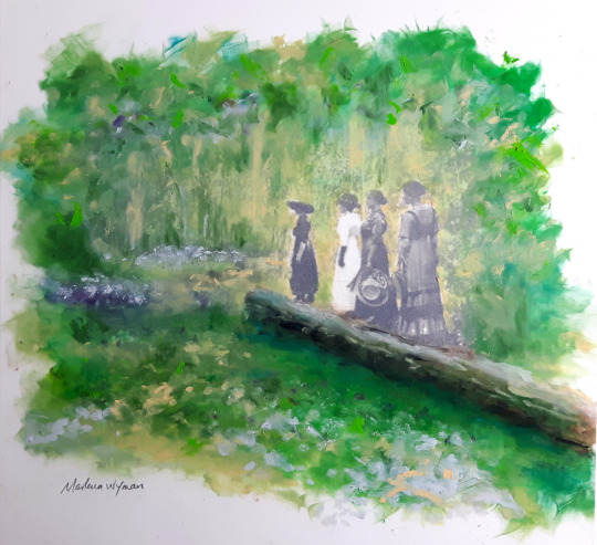
Outing in Laurier Park 1913 - Marlena Wyman - image transfer and oil stick on Mylar (Image from City of Edmonton Archives #EA-10-2927-15).
I think it is time to start writing what is in effect a history of Laurier and Buena Vista Parks because that is the setting for Yorath House. I’ve spent about four weeks researching aspects of this history. It was difficult getting this information and, thank heavens for archives and digital records.
The stories of how Laurier and Buena Vista Parks came into being spans a period of over 100 years: from the end of the fur trade era to the 1950s. The land on which they are located was originally the home of Indigenous Peoples, specifically the River Cree. The ward name, Sipiwiyiniwak, means “People of the River” in Cree. Yorath House is located in what became Buena Vista Park. It is like a “bull’s eye” in the centre of this important piece of land.
Gold Seekers and Homesteaders
In order to tell the story of the “Western Parks,” it is important not only to find out who owned the land but also to examine emerging visions of what cities should be, and their relationship to the land. Land settlement is part of the story of the signing of treaties with Indigenous Peoples and filing of homesteads. Though the fur trade was essentially over when settlement began in the 1880s, a new resource drew fortune seekers. In 1859, James Hector, a geologist with the Palliser Expedition, noted the presence of gold flakes at Fort Edmonton.
Gold rushes had been occurring in various parts of the U S in the first part of the nineteenth century. Tom Clover, a Missouri native and veteran of the California gold rush of 1849, in the 1860s heard about gold being found at Fort Edmonton and made his way here. The section of the North Saskatchewan River that he worked in the 1860s became the Cloverdale and Clover Bar neighbourhoods. Several early Edmonton businessmen also started out in the gold fields of California and BC including Timolean Love, Jim Gibbons, Ed Carey, William Cust and Donald Ross. In 1862, over 170 gold seekers known as “overlanders” (in contrast to those who took maritime routes) passed through Edmonton in July.1 While the majority were heading to BC, about 60 stayed in Edmonton to pan for gold along the River.
The transition from gold seekers to residents happened in the next 10 to 15 years. In 1866, James Gibbons, from Donegal, Ireland, was one of those gold miners. At the age of 15, he travelled to the US in 1852 visiting a sister in New York and an uncle in Delaware. Greed for gold took him to California and Nevada before he headed North to the Fraser River in BC (1859) and, finally, Edmonton. The signing of Treaty 6 enabled gold seekers and others to file for homesteads. The cross-over to settlement in what became Edmonton’s west end took place as a result of a Hudson’s Bay employee from Scotland. Malcolm Groat signed on with the Hudson’s Bay Company in 1861 and served at Fort Edmonton. By the time he ended his service with the HBC, he was in charge of farming operations at the Fort. In 1870, after the HBC selected their 3,000 acre land reserve around the Fort, Groat claimed 900 acres along the western edge of the reserve (what became River Lot 2), and settled there in 1878 with wife Marguerite and their nine children. She was the daughter of Chief Factor William Joseph Christie. Other HBC employees including Métis did the same. They established the pattern of long, narrow lots with river frontages on both banks of the North Saskatchewan. Many of their names are reflected in neighbourhoods or land features.
On the Miner’s Flats, now Buena Vista and Laurier parks, three gold-seekers and friends claimed land: Gilbert John Anderson, Thomas Charles Stephenson/Stevenson (so-called “English Charlie”) and James Gibbons. In 1873 Gibbons married Mary Isabel Anderson, a stepdaughter of Gilbert Anderson. With the help of his wife, who was Métis, he made several trips to Winnipeg to bring back trade goods. After 100 years of the fur trade, family ties were complex as a result of the inter-marriage of HBC employees and Indigenous women. Linda Goyette and Carolina Jakeway Roemmich note in Edmonton In Our Own Words:
Their descendants take care to describe the mingled lineage: Gilbert Anderson, who grew up among Cree relatives in the Enoch band, inherited his name from a Métis great-grandfather who was an HBC employee; but he was also great-grandson of Chief Michel Callihoo and a [great]-nephew of the early gold prospector Jimmy Gibbons. “These people were contemporaries in a small community,” said Anderson. “The families intermarried in the early years and that’s how Edmonton began.
Gibbons wrote a reminiscence in which he notes:
Christie was in charge at Edmonton. There were about twenty-five families about the place. They were French Canadians, half-breeds, and Highland Scotch. William Borwick was the blacksmith. William Lennie was also a blacksmith; there were those days two kinds of Scotch – those who could speak English and those who could not. Jimmie Gullion was the boat builder assisted by his brother, George. Pig Kenny was in charge of the pigs. Malcolm Groat was in charge of the men. There were two clerks in the post – McAulay and McDonald. Sandy Anderson was the saddler and made the dog harness. John Norris was dog runner. Donald McLeod was in the company service at that time and I remember that he spoke very little English. Gilbert Anderson was sawing lumber for the Company, and William Meavor was getting out the logs.”2
Gibbons filed for a homestead comprising 80 acres “on the North side of the Sask. River,” in 1878 (Section 24, Township 52, Range 25, Meridian 4). The records note that he has a family of five and will be using the land for “mining, farming and trading.” The value was placed at $1,000. His witnesses were Stephenson and Anderson. He later got a pre-emption for the adjoining land and, in 1893, he noted that he had 40 acres under cultivation, 25 “horned cattle,” 15-20 calves and yearlings, and 40 head of horses, mares and colts. In 1885, he applied for a “patent of home.” Gibbons also served as the Indian Agent for the Stony Plain Reserve (1898-1908) and, in that capacity, was involved in three key surrenders of lands: Enoch in 1902; Alexander Band in 1905; and the Michel Band surrenders in 1903 and 1906. Gibbons was the founding President of the Old Timers’ Association in 1894. He also filed for a homestead in Stony Plain in 1902 and purchased land and built a house for his retirement at 125 Street and 105 Avenue (this is a designated historic resource). He died in 1933.3
Gilbert John Anderson appears in the HBC Archives database of servants’ contracts: in 1852, he is listed as a “labourer” and, in 1862, as a “sawyer labourer.”4 On July 23, 1885, he filed for homestead Section 25, Township 52, Range 25, Meridian 4, which is also part of the Laurier Park lands. On January 24, 1894, he did another filing for Section 26, Township 52, Range 25, Meridian 4. The record shows that he had been a miner for 20 years and had two children, and that this would be his permanent residence. He also notes that he had broken the land and had cattle, four horses, a chicken house and a stable. Anderson was born in Stenness, Orkney Islands, Scotland on July 1830 and died in Edmonton in 1915 and was buried in the Edmonton Municipal Cemetery.
The last of the three friends to file for a homestead, in 1885, was Stephenson. He filed for Southeast ¼, Section 25, Township 52, Range 25, Meridian 4. His witnesses were his friends and neighbours James Gibbons and Gilbert Anderson. The land purchased by William Wilkin on which Yorath House is situated is part of this homestead. Stephenson was born in England in 1838 and died in 1923 in Edmonton and is buried in the municipal cemetery. In most records, his surname is spelled “Stevenson,” which made it difficult to locate his homestead papers, which were under the name “Thomas Charles Stephenson.”
Alberta’s Capital City: The Rush to Urbanization
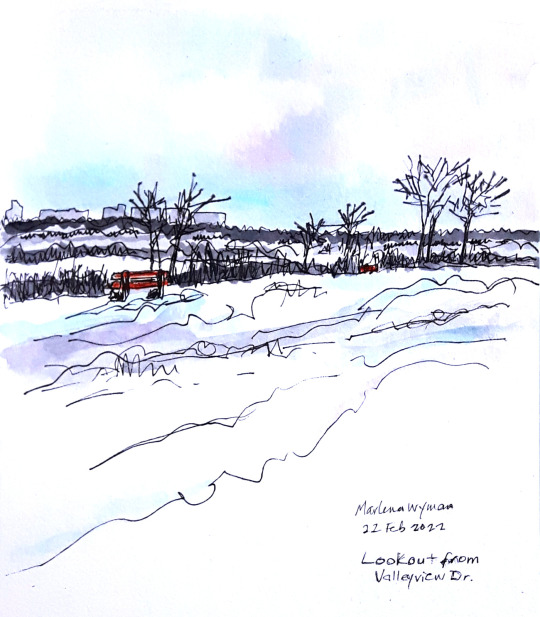
Painting of Valleyview Drive by Marlena Wyman.
Edmonton incorporated as a town in 1892 and as a city in 1904; in that time period its population rose from 700 to 8,350. In the early years of the twentieth century there was a feeding frenzy of property speculation. In 1903, Malcolm Groat sold his estate to property developers. In the same year, Charles Stephenson sold part of his land to realtor S. H. Smith, a city alderman (1906-07), for $12 an acre. Stephenson did not sell all of his land retaining a number of acres on which he and, later, his grandson, William Stephenson, resided. Maps from about 1912 show a square of land with river frontage in private hands.5
The extent of Edmonton’s property boom, partly fueled by the building of railways, is described by historian John Gilpin as follows:
Between 1903 and 1914, 274 new subdivisions were created, which inflated the assessed value of city property to $191 million. Most of these existed only on paper and would never be developed. This rate represented an 1800 percent increase in the number of subdivisions on the north side alone compared with an 800 percent increase in the total population of Edmonton between 1904 and 1914.
These new subdivisions were located on both sides of the river, with the largest concentration being northeast of the central business district. Mundy’s 1912 map of Greater Edmonton shows new subdivisions established as far as seven miles from the downtown area. The names chosen were common to other Canadian cities, and included Tuxedo Park and Queen Mary Park. With the exception of Windsor Park, Glenora, and Beau Park, these subdivisions did not deviate much from the grid pattern. The cumulative result was the creation of a blueprint for a “Greater Edmonton” that dazzled the imagination of Edmonton’s boosters, strongly influenced many aspects of civic policy, and created new opportunities for Edmonton real estate brokerage firms.6
The property speculation was also fueled by Alberta’s becoming a province on September 1, 1905 and Edmonton being designated as the capital in 1906. This was the result of powerful allies in Ottawa including Prime Minister Sir Wilfrid Laurier, who had been there at the inauguration of the province on a bandstand in the Rossdale Flats.
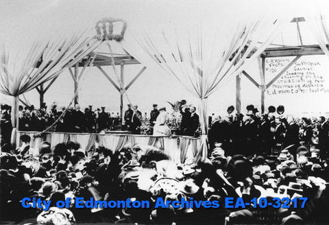
Sir Wilfrid Laurier speaking at the inauguration of the Province of Alberta, September 1, 1905 in Edmonton at the Rossdale Flats. Photographer: Ernest Brown, City of Edmonton Archives EA-10-3217.
The provincial government immediately began to plan for an impressive Legislature building and grounds, and 21 acres was purchased from the Hudson’s Bay Company for the site overlooking the North Saskatchewan River. In an article in the Bulletin of November 5, 1906, the headline states: “New C.P.R. Bridge Will Have Suitable Design: Architecture Will Accord With Surrounds and Harmonise With Provincial Buildings.” Premier Rutherford himself met with Sir Thomas Shaughnessy, head of the CPR, to discuss this and tells the journalist that landscape architect “Mr. F. G. Todd of Montreal” has been contracted, and notes that the same process was happening in Saskatchewan. The Province chose Todd because of his impressive credentials: he had studied with pre-eminent American landscape architect Frederick Law Olmstead, the designer of New York’s Central Park and Montreal’s Mont Royal.
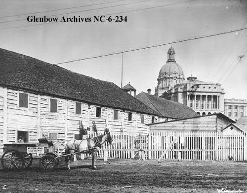
View of Fort Edmonton with the completed Legislature Building behind, ca. 1912, Photographer: McDermid Studio. Glenbow Archives NC-6-234.
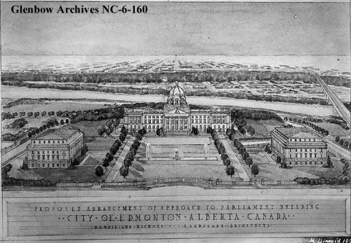
Drawing of proposed approach to Legislature building, 1912. The Legislature was built in the period 1907 to 1913, in the Beaux-Arts style and is an impressive steel-frame, sandstone and granite structure. It was designed by architects Allan Merrick Jeffers and Richard Blakey and Montreal architect Percy Nobbs helped with the final revisions. Photographer: McDermid Studio, Glenbow Archives NC-6-160.
A postcard showing a panoramic view with the completed High Level Bridge and Alberta Legislature, ca. 1917-1918, Glenbow Archives NA-5002-5
The City of Edmonton Archives has extensive correspondence pertaining to parks development in the period 1906 to 1912, including Todd’s 1907 typewritten report that presents a grand vision for the City. In November 1906, Todd was contracted “to prepare a comprehensive beautification scheme for the city” for a fee of $500. He begins by praising the civic government for initiating planning early and cites a number of examples of cities that had not done so, and had to do very expensive remedial work.7 He sees no limits for Edmonton, the capital of a resource-rich province, and makes a key recommendation:
In evolving a comprehensive scheme for parks and boulevards for Edmonton, every advantage should be taken of the great natural beauty of the situation, and also attention must be given to the economic interest of the city, by withdrawing for park purposes, property which is of least value for building, if it is equally valuable for park purposes. Indeed it often happens that the land most unsuitable for building is the best for park purposes, such as the sides of steep ravines and hillsides.
The report has the following sections: East and West End Parks, North End Park, Hudson Bay Flats, Ravine and Hillside Parks, Rat Creek Park, Groat Creek Park, Small Parks and Playgrounds, Boulevards and Parkways, Boulevard to Groat Creek, Boulevard to Rat Creek, Hudson Bay Boulevard, Namayo Boulevard, Capital Boulevard. He devotes a final section to “Plantings.” Thus, before Edmonton had even begun its urban development, it was committed to becoming a “green” city and part of the Garden City Movement that had gained dominance in the UK, the US and Australia. In 1898, Ebenezer Howard published a book titled Cities of Tomorrow. In it, he espoused a method of urban planning in which towns and cities are surrounded by “green belts” and a balance is struck between housing, industry and agriculture. Three such communities were built near London and he received a knighthood.
In the section titled “East and West End Parks,” Todd praises the City as follows:
Your city has already made a commendable start in the way of supplying its future generations with ample breathing space, by purchasing a good sized park East of the city, and one in the Western part of the city. These are splendid properties and well adapted to the purposes for which they have been set apart, and I would suggest that when these are developed later on as the city assumes a larger size, that as much as possible of their present natural beauty be retained, and that their natural picturesqueness be further increased by planting of many trees and shrubs in an irregular and natural way. When drives and walks are built they should be designed with graceful curves, and arranged with the existing and proposed woods in such a manner as to present the park to the best advantage.
The west end park purchase that he refers to is an as-yet unnamed area: it is part of the North ½ of Section 24 and West ½ of S.W. ¼ of Section 5, 52, 25, West of the 4th Meridian. The 205 acres belonged to James Gibbons and the city paid $25,625. The purchase was made through the power plant capital account because, initially, the City intended to move its power-generating facility from the Rossdale Flats to this site. In the City records, and also in articles in the Edmonton Journal and the Edmonton Bulletin, the matter is discussed. A December 29, 1906 article in the Bulletintitled “Recommends Gibbons Site for Water Work” notes that the Commissioner had had specifications prepared for a water treatment facility that would supply “three-million gallons” through a “direct-connected, motor-driven pump.” The other part of the proposal was for a power plant.
The move seemed to be supported by the City Commissioner because not only was there ample land but also water and coal. An article in the Journal of October 10, 1907 titled “New and Extensive Improvements Are Being Planned for Edmonton” provides information on the equipment for the power plant including generating capacity and notes that testing of coal deposits had been done. It does, however, point out an issue: “The Gibbons’ property is about three miles from the centre of the city in a direct line, but owing to a bend in the river it is about five miles distant by trail. In order to transport the heavy machinery to the plant to the site, and to provide communication with other coal mines in case the fuel supply should at any time fail, it is considered necessary to construct a spur line to the property.”
The urgency of expanding the current power plant and the drawbacks of Gibbons’ land supported the vision provided by Todd in his report, and the decision was made not to build on the west end site. By 1909, the Journalwas advocating for the location of a park there with the support of the City’s medical officer Dr. T. M. Whitelaw, who gave his hearty approval for a “large suburban park.” On July 29, 1910, it reported: “The advisability of christening the McGibbons [sic.] property Laurier Park will be considered at a special meeting of the council which has been called for Monday at 10 o’clock. At this meeting also a resolution urging the removal of the penitentiary from its present site will be drafted. The resolution will be presented to Sir Wilfrid Laurier during his stay in the city.”
Removing a penitentiary and designating an urban park were both part of the beautification of the City. The new provincial jail would be moved to Fort Saskatchewan, a more remote community in which to situate dangerous offenders. In 1910, Laurier travelled across Western Canada via railway for a period of two months. It was an electioneering trip to get in touch with this fast-growing region of the country. He stopped in Edmonton on August 10 where he was honoured by the park naming.
The influence of Frederick Todd cannot be underestimated. We experience it every time we walk or drive along roads and walkways on the embankments on both sides of the North Saskatchewan River. These reflect the following recommendation in his report:
The advantage of a system of boulevards and driveways connecting the different parks surrounding the city is of such obvious importance that it is hardly necessary to dwell upon it. Few cities have such splendid opportunities for magnificent scenic drives as Edmonton, and it will always be a matter of regret to future generations that land for a boulevard along the entire river embankment was not secured until it was too late to make it continuous. There is however still left the opportunity of obtaining boulevards commencing a little east, and a little west of the city, and the land for these it seems to me should be secured at as early a date as possible.
Laurier Park was the beginning of over 100 parkland purchases that the City undertook in the period 1907 to 1931. These included the Highlands golf course and the Mill Creek, Groat, Mackinnon, Kinnaird and Whitemud Creek ravine lands.8
With respect to the “West End Park,” on October 19, 1910, a proposed nursery was approved; the site comprised five acres. A December 20, 1910 document provides costs for clearing the land of burnt and dead timber. Itemized costs include: ploughing of 37 acres; brushing of 75 acres; mowing, curing, stacking of hay on 50 acres. In another document of the same date, the following activities with accompanying costs are listed:Todd had recommended the planting of many trees and the City took his advice to heart. On April 4, 1911, a Blue Print of the layout of the West End City Park is requested from the Engineering Department (unfortunately, it is not in the file).
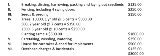
Todd had recommended the planting of many trees and the City took his advice to heart. On April 4, 1911, a Blue Print of the layout of the West End City Park is requested from the Engineering Department (unfortunately, it is not in the file).
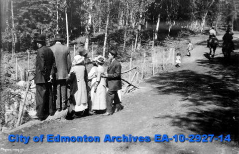
A family outing at Laurier Park in 1913; trail for not only walkers but also people on horseback was developed. Photographer: Byron May Co. City of Edmonton Archives 2A-10-2927-14
While Todd had set the City on the development of parks, in 1912, correspondence reveals that other landscape architects were also being consulted. Whether this was because Todd was unavailable or “new blood,” as it were, was needed is not clear. A September 16, 1912 letter from American Park Builders, Chicago, requests that they be placed in a position to bid for projects. They note that they can either plan and build the park, or use the plans of other landscape architects. To support the application, they note that they are responsible for the Lincoln Park System in Chicago.
Correspondence also relates to other parks existing at the time including Rat Creek Ravine and Victoria Park; and the building of proposed East and West “river drives.” All are costed fully by A. J. Latornell, the City Engineer. Other projects include roadways leading to the Legislature and the proposed CPR High Level Bridge. A letter dated September 26, 1912, deals with the acquisition of three ravines in the Quesnell subdivision for park purposes. It notes: “Quesnell Ravine would form a desirable addition to Laurier Park to the West, while the other two would form a nucleus of two parks between Laurier Park and West End Park. All three are useless for building purposes.” Market sites on both the North and South sides of the River were also planned.
The Parks Commission delivered its first report on December 31, 1912. During the year, they received proposals from Morell & Nichols, Landscape Architects and Engineers of Minneapolis for park planning work. They were invited to produce a report. In 1912 and 1913, at the recommendation of Morell & Nichols, prominent town planners from the US and Great Britain were brought in to provide public lectures. In addition, the Report notes that “A Womans Club has been formed for the purpose of studying Town Planning on the basis of Mr. Morell’s report.” To help get the message out, it is proposed that 2000 copies of the report be printed and sold to clubs at 50 cents per copy. It is also suggested that copies be made available free of charge to high schools and the University. Finally, the recommendation is made to Council that Morrell and Nichols be retained as the City’s town planning experts.
A January 23, 1913 letter from P. M. Barnes, Assistant Superintendent of Parks to Mr. R. B. Chadwick, refers to a report prepared by the Provincial Archivist, Miss Katherine Hughes, with recommendations for the naming of Edmonton Parks. They are as follows:
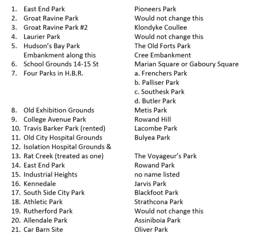
What is fascinating is that, in this era of white dominance, the Provincial Archivist recommended the following names: Cree Embankment, Metis Park, Blackfoot Park and Assiniboia Park.
According to her entry in the Dictionary of Canadian Biography, prior to coming to Alberta, she was linked to Indigenous causes. She was born in 1876 in Prince Edward Island and became a teacher and journalist and was a member of the Canadian Women’s Press Club. Her Uncle, Cornelius O’Brien was Archbishop of Halifax. According to the DCB entry, written by Pádraig Ó Siadhail,
Biographical sketches claim that she was involved in mission work for the “uplift” of natives in eastern and central Canada. In the summer of 1899 she was employed as teacher at the Mohawk reserve of Saint-Régis (Akwesasne). Two years later Hughes launched, with ecclesiastical support, the Catholic Indian Association, which sought to find employment outside reserves for graduates of Indian schools and, reflecting contemporary attitudes to natives, assimilate them.9
In 1906, she moved to Edmonton to work for the Bulletin reporting on provincial politics. In May 1908 she was appointed as the first provincial archivist and charged with developing the Bureau of Archives. In 1909, she was seconded to serve as the private secretary to Premier Alexander Cameron Rutherford and served in the same position for his successor, Arthur Sifton. In September 1913, she accepted the position of assistant and secretary to the agent general for Alberta in London, England.
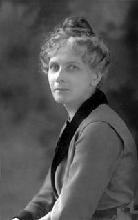
Katherine Hughes, first Provincial Archivist of Alberta, ca. 1906. The Provincial Library of Alberta along with the Provincial Archives was established in 1906. Provincial Archives of Alberta A5398.
Besides the list of names, Hughes also provided suggestions as to the historical periods to be commemorated through naming. This is an amazing document for its time. The periods are as follows:
1. The Indians.
2. The coming of the fur-traders, voyageurs, &c.
3. The rise of a new race – The Metis (mixed blood), halfbreeds.
4. The advent of a, The Missionaries, b, the gold miners, c, distinguished travellers or explorers (like Palliser, Southesk, Kane, Butler &c.)
5. The pioneers (free traders, independent of the big fur companies, settlers on farms &c. Mounted Police.
6. The era of the klondyke rush – very brief period, but one fraught with results, affecting Edmonton’s development.
7. The present day period of record making, growth and progress.
In April 1913, Morell & Nichols were advising about the setting up of shelters at East End Park, Groat Ravine, Laurier Park and South Side Park. Advice is also given on the building of playgrounds and a “swimming pool on Syndicate Avenue.” They also suggest that a gymnasium be added to the pool, perhaps the first multi-use recreational facility in the City. It is noted that the consultants had provided three “schemes” to date. In January 1913, the City hears from another landscape architect wishing to do business with the City: Thomas H. Mawson & sons from Vancouver. Their credentials and extent of their work is impressive. It is clear that the Commission is taking its work seriously and they add another name to their roster: L. L. May & Co. Inc. Nurserymen, Florists & Seedsmen from St. Paul, Minnesota.
Civic-minded individuals or, perhaps developers who had an interest in enhancement of their own property development ideas came forward to offer land to the City. Perhaps the most extensive was the proposal by Dr. L. L. Fuller of Strathcona to donate property for the development of Glen Lockhart Park in the Whitemud Creek area. The Bulletin of June 12, 1912 reported on the proposed donation of land as follows: “The only conditions attached to the offer are that the City develop the valley as a high class recreation and amusement park and make it possible for the citizens to get to it by building a car line to it. The exact area offered to the city will not be known until the survey is complete. It will be between 275 and 300 acres. The proposed lake will be 1 ¾ miles in length and some 100 acres in extent.” Fuller proposed building a dam to create Lake McKeen, which could be used by pleasure craft and could also be stocked with fish. The “park fever” incited by Todd would come to an end with the recession that began in mid-1913; this also would end the existence of the Park Commission.
Land Development: The West End
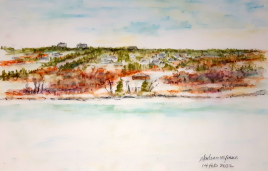
Yorath House and Laurier Heights from across the river - Marlena Wyman – water soluble wax crayon on Mylar.
While so-called “highlands” were the preferred sites for subdivisions for the wealthy and upwardly mobile (think of Ada Boulevard, Saskatchewan Drive, Connaught Drive and Valleyview Drive), areas bordering on parks were similarly desirable. There were enormous opportunities for realtors and property developers, who purchased lands adjacent to city limits to avoid paying taxes, and subdivided them into subdivisions. In 1906, Martin Runnalls established M. Runnalls Real Estate and Insurance Company and began land speculation. The year 1911 sees Runnalls entering into a partnership with Walter Ramsay, owner of greenhouses at Victoria (100th) Avenue and 110 Street and teacher; Dr. Edgar Allin, a medical doctor; Dr. Harry R. Smith, also a doctor; James H. Smith, realtor and land surveyor; and Norman B. Peak of Vancouver. They begin promotion of a new subdivision that Runnalls named Buena Vista (“beautiful view”) in keeping with Frederick Todd’s vision. They acquired land in River Lot 2, the old Stephenson homestead on the banks of the North Saskatchewan. Part of this might be the land purchased by Sam Smith in 1903 (I have been unable to determine whether Smith, the doctor, or Smith the realtor, were relations). A Plan was drawn up and it notes that the subdivision is part of Section 25, Township 52, Range 25, W4 of the Meridian and is described as Capital Hill South. The owner of the land is listed as William Stephenson. An ad in the Bulletin of April 26, 1911 has an image of the subdivision and offers lots for sale. It’s a boilerplate grid design with streets numbered “thirtieth” to “thirty-eighth” and the proposed avenues from north to south named: McMillan, Michigan, Hastings, Spadina and Laurier. The last reflects the nearby park. Lots are priced from $100 to $300 and the ad notes: “One-third Cash. Bal. 1 and 2 years at 7 per cent. Or 6 and 12 Months Without Interest.”
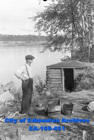
Squatter on the banks of the North Saskatchewan River, 1938. Photographer: Hubert Hollingworth. City of Edmonton Archives EA-160-451.
Buena Vista advertisement. Edmonton Bulletin, April 26th, 1911.
Another venture, in 1912, was the erection of a brick and concrete apartment building – the Buena Vista Apartments – with retail on the ground floor at 12327 – 102 Avenue. The building, designed by local architects Herbert Alton Magoon and George Heath MacDonald, cost about $11,000 and, when it opened in 1913, the Bulletin described it as “a most desirable residential property in the west end.” While this venture was a success, the companion subdivision was not completed though some houses were built.10 The recession prior to the First World War ended speculation in property.
The 1912 Driscoll & Knight Map of the City of Edmonton shows the huge land mass of the City (developed and undeveloped). In the left hand bottom corner, Laurier Park and Buena Vista lands are green areas forming an “L” shape. The vertical piece is Laurier Park (the current park is a smaller area because the Storyland Valley Zoo was built on the land in the 1950s) and the horizontal piece, by and large, is the unbuilt Buena Vista subdivision. There is a square piece of land that is unidentified; this is the Stephenson land that Yorath House would be built on.
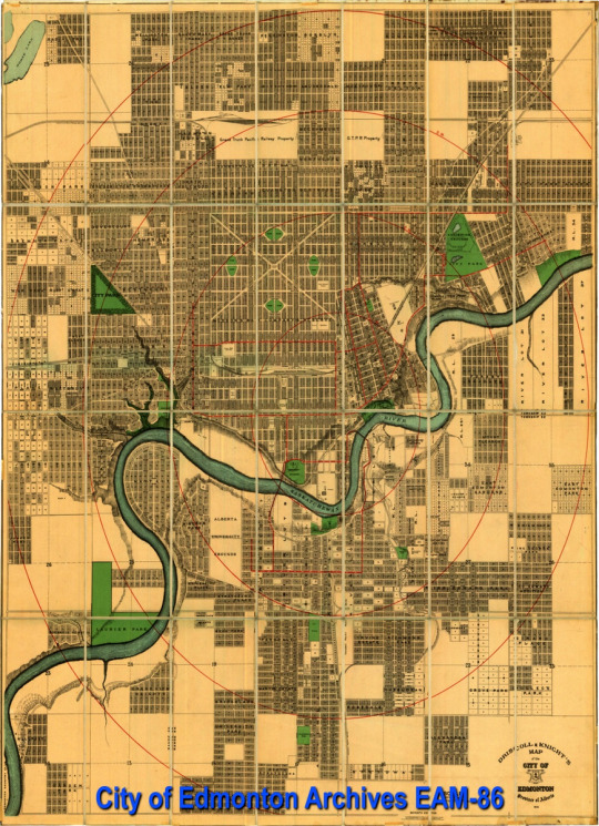
Driscoll and Knight Map of the City of Edmonton, 1912, City of Edmonton Archives EAM-86.
A review of the City Tax Rolls for selected years beginning in 1907 is very revealing. The degree of land speculation can be clearly seen in the number of properties owned by companies such as McDougall and Secord, the Riverview Land Company, Weber Bros. Realty and other businesses, as well as individual investors. Many did not reside in the City; for example some resided in Vancouver; others in various parts of Ontario and other Canadian provinces; and some even in the UK. As well, city-owned lots for parks and other developments are noted as are those owned by religious denominations (such as the Faithful Companions of Jesus) and designated for use as locations for churches, schools and hospitals. The earlier years in the rolls are listed in no particular order: just dates when property taxes were paid. Later, they are organized according to the name of the subdivision and it is easier to review all of the Buena Vista records.
City of Edmonton Tax Rolls selected years from 1907. City of Edmonton Archives. Photographer: Adriana A. Davies.
The economic recession can be seen in these records and the column of payments with red ink indicating arrears becomes the norm. As individuals and companies defaulted on tax payments, the City seized the property in lieu of payment and then would hold property sales with ads appearing in newspapers. Buena Vista lands owned by the Riverview Land Company, which were likely seized by the City for non-payment of taxes before 1915, appear in a 1918 advertisement for the sale of City-owned land in the Bulletin (Monday, June 10, 1918). It is noted that a number of properties, including Buena Vista (the first on the list), were removed from the sale. This may mean that either Runnalls and his partners paid the arrears, or that someone else purchased the land. The 1920 tax rolls show a number of Runnalls or Riverview Co. properties not only in Buena Vista and Laurier Park areas but also in other parts of the City being in arrears; however, very few have a stamp indicating that they had been/or were to be sold.
I examined Tax Rolls for select years beginning in 1907 and this proved fascinating. All of the noted property developers are there (many of whose names are immortalized in City features including roads, parks and subdivisions) can be seen to own property all over the City. Martin Runnalls from 1911 owns a lot of property not only in River Lot 2 but also in other areas of the City as does the company he created with partners, the Riverview Land Company. The year 1921 is fascinating because of the number of property owners who are in arrears; the status column noting arrears is literally bleeding red. Both Runnalls personally and Riverview Land Company are in arrears in many properties; however, they have not as yet forfeited their properties for non-payment of taxes. Many individual landowners had. The City was in major debt and this faced the new Commissioner for Public Works, C. J. Yorath who was hired in 1921. He had held the same position in Saskatoon from 1913 and had got them out of debt as well as developing the new City Plan based on Garden City models. The Tax Rolls get easier to review once they are set out according to subdivisions/neighbourhoods. Buena Vista had quite a number of residents indicating that Runnalls and the Riverview Land Company had succeeded in selling lots and houses had been built.
From the 1907 Tax Roll onward, it can be seen that as new immigrant groups arrived in the province, they purchased land. This includes not just people from the UK and the US but also Ukrainians and Germans. A number of properties are also owned by women. In Buena Vista, there are about 34 property holders listed in the Tax Rolls including lots 8 to 14 owned by W. L. Wilkin and his wife Hilda Wilkin.
The recession prior to the First World War continued through the war-time years when government funding was focused on the war front, through the 1920s, the Great Depression of the 1930s, and, then into the Second World War. Surprisingly, during these difficult times, the City of Edmonton and province of Alberta did not lose their interest in beautiful communities. In 1928, the Town Planning and Preservation of Natural Beauty Act was passed by the Government of Alberta. While the “natural beauty” in the title suggests that some of Frederick Todd’s tenets are embedded in it, this is not the case. The legislation enabled municipalities to formulate and carry out planning schemes and is as dry-as-dust.
City records in the Archives indicate that just before the Dirty Thirties, Edmonton officials were much preoccupied with town planning as they prepared to host the Town Planning Institute of Canada Convention. The 1930s brought an end to most planning activity in Canada and the Institute was disbanded in 1932 and not revived until some 20 years later. The List of City Parks 1931 is an important document because it shows the progress that the City has made since 1907 when Todd promoted the designation of parks sites. Two land acquisitions in the document are of particular interest because they pertain to the area of the “westerly park”:
Quesnell Heights
All that portion of N.W.¼ of Section 23-53-25 W. 4th, 107 Acres, excepting thereout the areable land, 51.2 Acres more or less.
Date Acquired: 1918.
Purchase Price: no price listed (could this be a property forfeited for non-payment of taxes).
Land Assessment: $3,250.00.
Area: 55.8 Acres.
Laurier Park
Pt. of the N.½ Section 24 & W. ½ of S.W. ½ of Section 25-52-25 W. 4th.
Date Acquired: 1906.
Purchase Price: $25,625.00.
Land Assessment $20,500.00.
Area: 205.0 Acres.
This document also refers to a significant land donation in Groat Estates/Glenora; the wording is as follows: “Donated by Jas. Carruthers in consideration of Bridge over the Ravine being built forty feet wide. The Title is subject to a Caveat filed by Jas. Carruthers.” This would set a precedent for donations of land for park purposes. Carruthers was a Montreal grain merchant and entrepreneur who, in 1905, purchased the Groat homestead from other real estate promoters. His plan was to build a subdivision for individuals who could afford to spend at least $3,500 on a residence; this subdivision became Old Glenora. Carruthers faced the difficulty of getting over the Groat Ravine; as a result of some wheeling and dealing with the City, in 1909, he committed to build a 20-foot wide bridge in exchange for a municipal street car route on 102 Avenue into his subdivision. After further negotiations, Carruthers committed to building a 40-foot wide bridge and donated two parcels of parkland in the adjacent Westmount area in exchange for the City paying the additional bridge building costs. The bridge was built in 1910; however, because of the recession that followed shortly after in 1913, his grand vision was truncated but the city retained the donated property. Eventually, Westmount would be developed as a suburb for young professionals.11 The Edmonton Historical Board entry on the suburb notes:
Thought to be named after the suburb of Montréal, the community of Westmount is bounded by Groat Road, 111 Avenue, 121 Street, and Stony Plain Road. It also includes the Groat Estate area south of Stony Plain Road between Groat Road and 124 Street. A large portion of homes in this neighbourhood were built in the land boom of 1912. Apartments make up about half the living space, but only appeared relatively recently in the 1960s and 1970s along major traffic routes.
A key piece of legislation was passed in 1933 – the 1933 Zoning Bylaw that delineated 12 zoning districts that specified use and building type. It would appear that the City was prepared for orderly development but this would have to wait until the late 1940s.
A rebound in property values and development required the coming in of the Leduc and Redwater oil fields in 1947 and 1948, respectively. This began a boom that would last until about 1980. In this period, the City of Edmonton grew dramatically and infrastructure to support the growth was built. This was the era of the Modern Style epitomized by the architectural firm of Rule, Wynn and Rule. With respect to development in the west end, the realty firm established by L. T. (Timothy) Milton came to the fore. Melton came to Edmonton in 1918 from Winnipeg and learned the business in the offices of Allan, Killam, McKay and Greene where he worked until 1922. The next year, he opened the Stanley Investment Company named for his son, and, in 1932, the company changed its name to L. T. Melton Realty. A 1945 ad in the Journalof May 17, 1945 advertises a subdivision as follows: “River Frontage and Capital Hill South 138 St. and 90th Ave. Acre lots $40 cash, balance $25 per month give you title in 10 months. West End Acreage ‘in a growing city is the best investment on earth’.” The West End Office is located at 14921 Stony Plain Road.
In 1947, his son Stanley, on returning from fighting in the Second World War, took over the firm and filed a subdivision plan for Capital Hill South (N.E.¼ & N.W. ¼ Sec. 25 – Tp. 52, Rg. 25, M 4). It shows a strip of land, named Melton Hill, above what is now the Valley Zoo. This indicates Melton’s interest in the development of the West End communities running across the brow of the north bank of the North Saskatchewan River (Capital Hill, Valleyview, Crestwood, Parkview and Laurier Heights). The company website notes: “Development of the Laurier Heights subdivision residential neighbourhood in west Edmonton begun postwar with approximately six out of every ten residences (58%) being built between 1946 and 1960, and approximately four in ten residences being built between 1961 and 1970.” By 1953 there were 16 Melton branch offices in Edmonton.
The Wilkin and Co. realty and insurance firm was tiny in comparison to the Melton and Weber Bros. firms but, according to Richard Wilkin, his grandfather likely acquired the riverside lands in the Buena Vista subdivision around 1945. That was the year that he purchased land on Connaught Drive to build a home for himself and wife Hilda. The firm, which in the 1950s was run by Wilkin’s son Bill (Richard’s Father) had its offices on the ground floor of the Buena Vista Building on 124th Street and 103 Avenue. When Dennis Yorath, Wilkin’s son-in-law was transferred from Calgary to Edmonton to head Northwestern Utilities, he required a home for wife Bette and daughters Gillian and Jocelyn. Whether Wilkin senior donated the land or sold it to Dennis is unknown; Richard says either option is possible since his Grandfather was a shrewd businessman and his Uncle would have had some type of housing allowance from the company.
There is no question that the house that Dennis and Bette built in 1949 was intended to make a statement: he was part of the elite of Edmonton/Alberta businessmen intending to lead the province into its second half century. The couple chose the architectural firm of Wynn & Rule to design a two-storey home. The house, which was 4,380 square feet, was built near the river edge on a 12-acre lot. The building remains a symbol of design and architecture of the period known as the Modern Style. The house was distant from other subdivisions with few amenities nearby. It seems that Dennis as head of Northwestern Utilities was able to get power there, gas came later as did water (until at least 1959 they used well water). The house had to be reached via 81 Avenue because Buena Vista Road did not exist.
The few houses nearby in what would have been the Buena Vista subdivision were, according to Richard, small cottages or even shacks. Agricultural activities were still taking place in the area and there was a gravel pit in what is now the car park near the house. For a time, there was even a mink farm. Dennis donated a fieldstone chimney, what was left of the original Stephenson log home to the City. A letter in the City Archives dated October 22nd, 1949, thanks him for the gift and notes: “The fireplace is to be rebuilt, according to current plans, at some suitable location and when this is done the descriptive placard to be attached will make note of your thoughtful donation…. As you know, the fireplace was the oldest relic of early Edmonton still in existence. Without your permission for removal, it would have been lost forever.” The City would later inform him that the fireplace could not be rebuilt. There are, however, some fieldstone pillars at the entrance of the property and the family built a cairn near the embankment to honour the Wilkins. The building of the Yorath home would mark a shift in the City’s planning with respect to River lands.
Rebirth of the Garden City
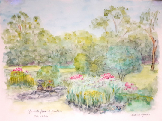
Yorath family flower garden ca. 1980s by Marlena Wyman – water soluble wax crayon on Mylar (based on a family photo of the garden).
The year 1950 saw the City repeal the 1933 Zoning Bylaw on the grounds that it was outdated and passed the Interim Development Bylaw No. 1. This enabled Council to make development decisions based on individual cases. An article in the Edmonton Journal of February 27, 1951 titled “New Subdivision Plan Authorized,” notes:
City council Monday night authorized the filing of a subdivision plan for residential development in Capital Hill south. To this was added a recommendation that the city exchange land it owns for privately owned lands in order to protect riverview land.
Commissioner Menzies estimated it would be at least two years before utilities were brought into the area. He also said there would be restrictions as to the type of residence which could be erected. Ald. Clarke had remarked that this was one of the good residential areas available in the city and asked for assurance there would be restrictions on the type of house constructed.
The upshot of Council deliberations was that further park development would occur in the Laurier Park area and that the City was prepared to use the “first right of refusal” to force property holders to sell to them. A further article in the Journal of April 4, 1957 titled “Buena Vista Park Plan Wins Committee Vote,” notes that the Finance Committee had recommended development of the Buena Vista lands around 142 Street to be developed as a park. There was, of course, opposition and residents who opposed the plan were represented at the Council meeting by Cameron Steer. He is quoted as follows:
Mr. Steer charged that “What the city really seems to be doing is freezing the home-owners’ capital until the city is good and ready to use the land for its own purposes.”
“The city is obligated to buy as soon as the home-owner is ready to sell.” Mayor Hawrelak answered. How is this any different from about 50 other situations in the city?”
“In this case the city doesn’t intend to do anything for years,” Mr. Steer said. He argued that residents moved into the area under the assumption it was residential land “and in June 1954, like a bolt out of the blue, the situation was changed.” That, he said, was when council decided definitely the land would be used for park purposes although as commissioner Menzies pointed out, it was zoned as park in 1933.
Prior to the interim development by-law in 1951, “the private owner could develop the land as a unit.” Mr. Steer said. “In 1951, that protection was taken away.”
The April 1958 Map of the City of Edmonton, according to the legend, shows transit routes, public and separate schools, hospitals and neighbourhoods as well as the City boundaries. It provides an aerial view of Laurier Park and the Buena Vista subdivision spanning 34 lots from 76th Avenue, which is closest to the River, to 8th Avenue, and from 138th Street, which borders on Laurier Park, to 130th Street. It also shows the layout for the Valleyview and Laurier Heights subdivisions. The creation of Buena Vista Park is evident. The area dedicated to Buena Vista Park and Laurier Park comprises 110 hectares, while the residential neighbourhood comprises 132 hectares.
The 1951 tax rolls list the following owners of land in Buena Vista: Hilda R. Wilkin and W. L. Wilkin (owed A78, A79 and A80); City of Edmonton (gravel pit, A81, A82 and A86a); Edward B. Fisk; Margaret Smillie (New York); Arthur S. Cummings; Arthur S. Cummings (Winnipeg); Andrew & Muriel Lucas; Robert F. & Audrey G. Aitchison; Philip Gabel; Frederick M. Wilson; J. Wilbert Wright; Estate of B. S. Muttart; Amy E. Sherman; Ella M. Muttart; Esther Ross Clindinin; Harley G. Nilson; Bertha M. Challis (Altadena, Calif., U.S.A.); City of Edmonton, A22 Lots 12 & 13; Evelyn M. Allen; Cecil B. Atkins; Chas. W. Hosford; Thomas & Mary V. Sinton; Cecil B. Atkins; D. G. Sandilands; Evelyn M. Allen; William A. Dreany; J. R. Washburn; William A. Dreany; Nolan O. Blaylock (owned multiple lots A37, A38, A39 and A40); Christie V. Blaylock; Winnifred Crawford; Charles A. H. Lawford; Florence E. Deltombe; Hollis D. Howard; Arthur S. Cummings; John Welling; Frank H. & Bessie C. Kenwood; Albert F. & May D. Oeming; Wolfred J. & Leona M. Law; Daniel J. & Eva Driscoll; Wilfred J. & Leona M. Law (they owned two lots A59 and A59b); Albert F. & May D. Oeming (owned A60 Lots 16 to 20); City of Edmonton (owns a series of lots A62, A63, A64, A66, A66a (old gravel pit); Alberta & Hattie Lewis; John F. & Winnifred Crawford; Albert & Hattie Lewis (owed A70 and A72); John W. & Winnifred Crawford (owed A72c and A72e); Charles Henry Smith (W. Finchley, London 3, England); Jessie A. Ohlsen; Earl Enger (owns A74 and A75); Merrill H. & Winnifred C. Baker; Maud L. Thomas (New York); Florence Southall; and George M. & Jean Bates (owned A77a and A77b).
There are a number of interesting observations: some of the owners did not live in Edmonton; a number owned multiple properties; and the City already owned property in the subdivision. Richard Wilkin and the Yorath sisters (Gillian and Elizabeth) remember a number of agricultural enterprises there including a stable (the family also kept two horses on the property), a berry farm and a mink farm. Gillian remembers when newly-licensed driving her car through the gravel pit and almost tipping the car over with her baby sister inside. Elizabeth remembers Al Oeming and his fierce cheetah, which he kept on the property. This was in the 1950s.
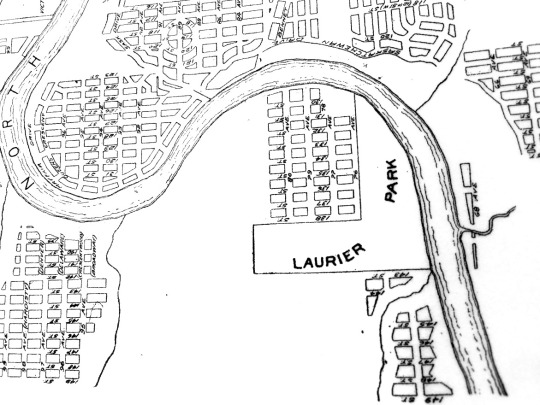
City records in the Archives indicate that some of the property holders chose to enter litigation with the City to preserve their land. There was an immediate impact: after the introduction of the Interim Development Bylaw No. 1, no more building could occur in the area. Richard Wilkin says that his Father Bill had been intending to build a house on one of the lots 8 to 14 held by the Wilkin Co. but could not do so. As owners decided to leave for a variety of reasons, the City took possession of the land that became Buena Vista Park.
The City of Edmonton District Names Advisory Committee Minutes of June 27, 1956 approved the naming of what is described as a driveway: “This will be a view drive overlooking Laurier Park, the zoo area and the Saskatchewan River. Laurier Drive is suggested because of the subdivision and neighborhood unit name which is “Laurier Heights.” The new subdivision of Laurier Heights was bounded by 87 Avenue to the north (west of 142 Street), 149 Street and Highway 2 to the west (later Whitemud freeway), Buena Vista Park and the Edmonton Valley Zoo to the east, and the North Saskatchewan River valley to the south. It was marketed by real estate companies such as Melton as a neighbourhood for young families with means and a range of amenities were built including a school at 8210 – 142 Street and community League located at 14405 - 85 Avenue; the latter comprises a community hall, outdoor rink and tennis courts.
To add to the amenities of the upper-middle-class subdivision, on July 1, 1959 the City opened the Storyland Valley Zoo, which was built on Laurier Park lands.12 The Edmonton Zoological Society, in 1926, had established a zoo in East End Park, created by the City in 1906. The 140-acre park was renamed after a 1914-visit to the city from then PM Robert Borden. This paralleled the earlier naming of the “West End Park” in 1910 for PM Sir Wilfrid Laurier. In 1930, likely for economic reasons, the City took over the operations of the Zoo from the society that had established it.
Borden Park was a popular destination not only because of the zoo but also other amenities that included the City’s first swimming pools, a tearoom, and carnival features including a carousel, roller coaster and tunnel of love. By the 1950s, declining attendance and the need for the Edmonton Exhibition Society to expand its facilities and grounds had the City focused on relocating it and the Laurier Park site seemed ideal: the City was acquiring land to create Buena Vista Park and the new Laurier Heights neighbourhood was focused on attracting upper-middle-class families. Locating a zoo there focused on children seemed ideal. To build public interest, the Names Advisory Committee designed a public naming contest and, on September 3, 1957, Storyland Valley Zoo was chosen. By 1958, plans had been developed to have a five-acre children’s zoo, two lagoons, a bridge, and mini-railway and illustrations that featured storybook characters and animals. The miniature Allen Herschell 5-16 train became so popular that a second train, the Valley Zoo Express, was added in 1965.
As popular opinion turned against zoos and they became viewed as “prisons” for animals, the City embarked on change. The zoo introduced some “natural” habitats and focused on animals native to the region and conservation of wildlife was also promoted. To reflect this change, in 1975, the name was changed to Valley Zoo and the “storyland” element was dropped. The most recent major addition, which was announced in 1910, was a $43 million project resulting in new state-of-the-art facilities.
Adjacent to Yorath House in Buena Vista Park is the home of the Edmonton Rowing Club and the White Water Paddlers. A group of rowing enthusiasts, in 1972, created a rowing club and registered as a not-for-profit society. They initially stored their shells at the Mayfair Golf Club near the foot of Groat Bridge. This was not an ideal location because of the amount of debris that gathered there. The rowers moved their facility to Saunders Lake east of Leduc. Ultimately, the City of Edmonton gifted them land and they were able to build a permanent facility with the White Water Paddlers, who registered a society in 1973 to promote canoe and kayak paddling for recreation and competitive purposes. Both societies fundraised to build the facility.
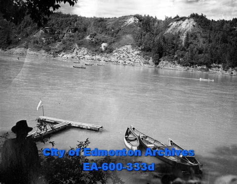
Edmonton Voyageurs Canoe Club Annual Regatta, North Saskatchewan River, August 1947. City of Edmonton Archives EA-600-333d.
Parks development from the 1950s was largely ad hoc though the locations identified in 1912-1913 documents were surprisingly prescient. This was to change: the City strengthened its efforts to improve land use planning and control by passing the 1977 Planning Act. Efforts to reinforce park development continued and culminated in the City’s 1990 Ribbon of Green: North Saskatchewan River Valley and Ravine System Concept Plan. The introduction harkens back to Frederick Todd’s recommendations made in his 1907 report. Section C is devoted to “Whitemud, Buena Vista and West Central River Valley Area” and spells out the capital costs to accomplish proposed work that was pegged to cost over $30 million. The following projects were planned:
- Whitemud Park to Laurier Park Pedestrian Bridge
- Buena Vista Park to Wm. Hawrelak Park Pedestrian Bridge
- Mayfair to MacKinnon Pedestrian Bridge
- 11.5 km main trail (West end of Ft. Edmonton Park to High Level Bridge
- 2 minor amenity nodes; Buena Vista Park improvements (road, parking and park improvements)
- access trail development
- Fort Edmonton access road relocation
- Fort Edmonton facilities (hotel)
- Valley Zoo infrastructure and
- Muttart Conservatory/Grierson Hill.
A map in the plan indicates through green arrows the area where work would take place. These measures can all be described as intended to improve access and the visitor experience rather than protecting the sites.
The death of Bette Yorath in 1991 triggered the City’s acquisition of Yorath House from her estate in 1992. The cycle of development of a “westerly park,” which began in 1907 when the City acquired the Gibbons lands, was, thus, completed through the consolidation of the Laurier/Buena Vista park lands. In 2015, Yorath House was designated as a Municipal Historic Resource. In 2019, renovations were completed. Projected at about $2 million when the property was designated, costs rose to over $5.7 million because of difficulties encountered. The official opening took place on September 20, 2019. The restorations to the house, while maintaining the look of the original exterior, would not be as respectful of the interior. The house was gutted and few original architectural features were kept other than the huge fieldstone fireplace and brick and wooden detailing. Bringing it up to code became the imperative so that it could serve its new purpose: a multi-use facility for small gatherings. The integrity of its inherent heritage value was by-and-large ignored.
Wise Use
Part of the 51 acre site in the river valley that would lost to the proposed EPCOR solar farm - Marlena Wyman – ink and watercolour on paper (I painted this soon after the solar farm was first proposed).
Jane Jacobs in her 1961 book titled The Death and Life of Great American Cities attacked 1950s urban planning policy with its emphasis on slum clearance and the building of freeways in urban areas. She rejected large-scale urban development projects and insisted on preserving the integrity of old neighbourhoods because of their human scale. She was also an activist who used protests by ordinary citizens to challenge government policies and projects. She did this in her home neighbourhood of Greenwich Village in New York. After her family’s move to Toronto in 1968 to avoid her sons’ being drafted into the American military to fight in the Viet Nam War, she also championed Toronto neighbourhoods and opposed the building of the Spadina Expressway that would have seen the disappearance of swaths of historic neighbourhoods.
A fascinating National Film Board of Canada documentary titled “City Under Pressure,” directed by Theodore Conant in 1965, places Edmonton squarely in the debate between freeways and parkland.13 In 17 minutes, it captures Mayor William Hawrelak talking about development and making the point that once something is lost (by implication through slum clearance or under a paved roadway), the clock cannot be turned back. A number of un-named “talking heads” make their points; these include aldermanic and mayoral candidates, and civic officials and planners as well as engineers. Key players in the 1964 election, besides Hawrelak, were G