#mapmondays
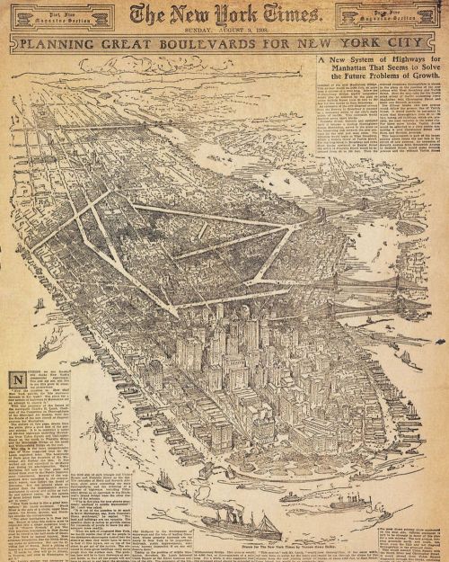
#MapMondays - Charles Lamb’s Diagonal Plan for New York City, 1904.
Lamb was one of the numerous planners at the turn of the century who made it their mission to improve the city through public art, the creation of new streets, parks, bridges, and civic masterplans. As Gregory Gilmartin noted in Shaping the City, “Charles Lamb trained his intelligence on an amazing variety of urban issues: from skyscrapers and street signs to a proposal for communal kitchens that would, he hoped, save women from the drudgery of housework and free them to join in the city’s public life. Few people have had such an effect on the shape of New York and yet been so thoroughly forgotten.”
One of Lamb’s most interesting plans was to break up the grid with a diagonal plan, relieving congestion and creating public squares like those along Broadway, the only diagonal street in the modern grid. Lamb discussed his proposal in detail in the April 1904 issue of The Craftsman:
“Broadway, the one great diagonal through New York, proves how essential such diagonals are, and it is but recently that a serious attempt has been made to- suggest modifications and improvements in the present plan of New York, so as to rectify many of the difficulties and adjust the changes to the inevitably increasing congestion of the growing metropolis…
This permits the development of the city to the utmost that might be possible within many decades, because with the hexagon, the great advantage of the diagonal already discussed is secured, and, at the same time, intervening spaces which can be secured for playgrounds and park areas, between the large central areas, which, in turn, can be used for groups of civic buildings in certain parts of the city, and, again, in other parts of the city seats of learning, recreation, business in all its forms, banking, publishing, the newspaper industries, and the thousand and one trades, which, in their turn, seem to be desirous of grouping themselves around a common center.” (Charles R. Lamb, City Plan, The Craftsman, April 1904)
(at Union Square Park)
https://www.instagram.com/p/Caz6FU5Ophq/?utm_medium=tumblr
Post link
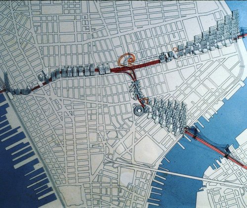
#MapMondays! Lower Manhattan Expressway, feasibility study by #burtalist architect Paul Rudolph.
The Lower Manhattan Expressway would have connected the Manhattan and Williamsburg Bridges to the Holland Tunnel with a ten lane highway, demolishing much of the #Soho, #NOLITA and #Tribeca we know today. The 1967 proposal would have been covered with brutalist housing blocks, a monorail, and a transit center.
The 1967 study was the final push for the expressway before it was finally canceled in 1971. The New Yorker explains Rudolph’s intentions and vision, “In 1967, presuming that the expressway was a done deal, Rudolph didn’t oppose it in the manner of Jane Jacobs, whose argument that it would have brought far more urban destruction than urban renewal ultimately carried the day. Instead, he took on the challenge of figuring out how to mitigate the highway’s impact on the city, and turn this incursion into something positive.
Rudolph’s idea, in effect, was to double down on the intervention, to build so much around and atop and beside it that the expressway would seem almost irrelevant. Rudolph envisioned what was, in effect, a megastructure extending all the way across Manhattan—a whole series of buildings that stretched, nearly unbroken, from river to river. Some of them straddled the expressway, others were towers arranged in clusters, and still others were in the form of slabs that Rudolph placed along the approaches to both bridges, turning them into walled corridors. He designed many of the buildings as gigantic frames to hold prefabricated apartment units that were to have been slipped into the structures. There were “people movers,” gliding along tracks connecting the buildings, and several floors of open automobile storage at the base of many of the apartment towers.
It was ridiculous in some ways, a futuristic city of the absurd. It ignored the streets, the lifeblood of New York’s urbanism, in favor what seems today like a brave new world of anti-urbanism…
Indeed, he was proposing an intervention far more massive than anything Robert Moses ever conceived, an entirely new vision of what the city could be.” (at SoHo Cast Iron Historic District)
https://www.instagram.com/p/CZIQy0nuhgl/?utm_medium=tumblr
Post link
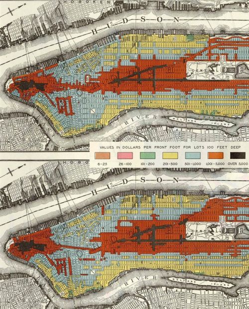
#MapMondays Manhattan land values, 1914 - 1923
https://www.instagram.com/p/CUqd8_hASGt/?utm_medium=tumblr
Post link
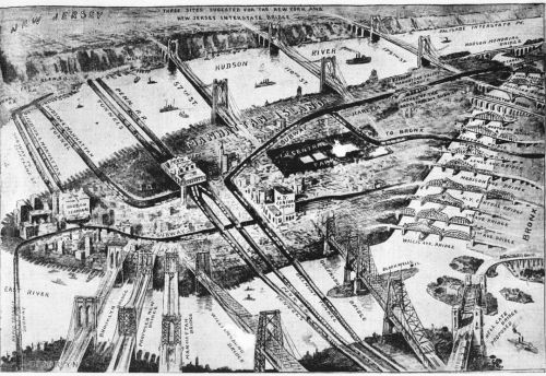
#MapMondays 1911 map of current and proposed NYC bridges and tunnels.A bridge between to Brooklyn and Manhattan Brides? Three Hudson River Bridges connecting NJ and Manhattan decades before the GWB? These were the ambitious visions of planners in early twentieth century. (at Brooklyn Bridge)
https://www.instagram.com/p/CUDBcIHAnUA/?utm_medium=tumblr
Post link
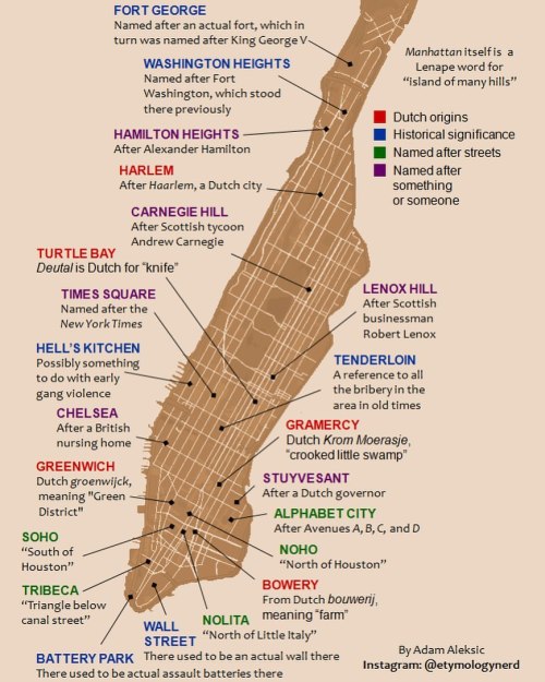
#MapMondays - Manhattan’s Hidden Etymologies: Interesting neighborhood name origins by @etymologynerd (at Tribeca)
https://www.instagram.com/p/CQG0ha0n8BX/?utm_medium=tumblr
Post link
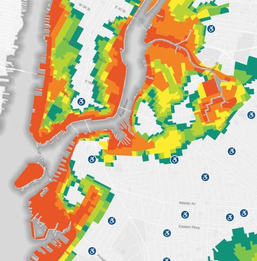
#MapMondays – the recent update to the NYC Flood Hazard Map identifying hurricane evacuation zones around the city. The six evacuation zones now include over three million residents located in low-lying areas that are vulnerable to flooding. This includes large swaths of Lower Manhattan, Long Island City, and southern Brooklyn. (at Red Hook Waterfront, Brooklyn)
https://www.instagram.com/p/CP1PZ–HKRg/?utm_medium=tumblr
Post link
#MapMondays!Lower Manhattan Expressway, feasibility study by #burtalist architect Paul Rudolph.
The Lower Manhattan Expressway would have connected the Manhattan and Williamsburg Bridges to the Holland Tunnel with a ten lane highway, demolishing much of the #SOHO and #NOLITA and #Tribeca we know today. The Paul Rudolph study of the highway in 1967 would have covered the corridor with brutalist housing blocks, a monorail, and a transit center.
The 1967 study was the final push for the expressway before it was finally canceled in 1971. The New Yorker explains Rudolph’s intentions and vision, “In 1967, presuming that the expressway was a done deal, Rudolph didn’t oppose it in the manner of Jane Jacobs, whose argument that it would have brought far more urban destruction than urban renewal ultimately carried the day. Instead, he took on the challenge of figuring out how to mitigate the highway’s impact on the city, and turn this incursion into something positive.
Rudolph’s idea, in effect, was to double down on the intervention, to build so much around and atop and beside it that the expressway would seem almost irrelevant. Rudolph envisioned what was, in effect, a megastructure extending all the way across Manhattan—a whole series of buildings that stretched, nearly unbroken, from river to river. Some of them straddled the expressway, others were towers arranged in clusters, and still others were in the form of slabs that Rudolph placed along the approaches to both bridges, turning them into walled corridors. He designed many of the buildings as gigantic frames to hold prefabricated apartment units that were to have been slipped into the structures. There were “people movers,” gliding along tracks connecting the buildings, and several floors of open automobile storage at the base of many of the apartment towers.
It was ridiculous in some ways, a futuristic city of the absurd. It ignored the streets, the lifeblood of New York’s urbanism, in favor what seems today like a brave new world of anti-urbanism.” (at SoHo, New York)
https://www.instagram.com/p/COsletMnGdG/?igshid=wxs9nu6e9o82
Post link
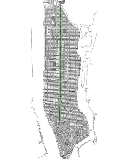
#MapMondays! Ernerst Flagg’s 1904 proposal to sell off Central Park and built a grand parkway connecting City Hall with the Harlem River. Flagg explained the need for the project, “[at] four times the width of that of Fifth Avenue, there would still remain for gardens distributed on both sides of it a space about as wide as Madison Square is long. Now imagine this strip of verdure extended for ten miles through the heart of the town, shaded by trees, ornamented with shrubbery, fountains, statuary, arches, and every other suitable embellishment, and where could one find its equal? The finest of avenues of the old world would pale in comparison. The Mall at Washington as it is proposed to rearrange it would not be as wide and only about one-fifth as long…
“What can be said for an improvement which practically closed the two central avenues, and placed the park on the natural axis of traffic? Central Park is still regarded by most New Yorkers with pride… but the time must soon come when the disadvantages of its location will be too apparent to be hid…
Ornamental grounds of this sort should not be so wide as to be inconvenient and serve as a barrier between the adjacent parts of the city as Central Park does…
Since Central Park was laid out conditions have changed; with the completion of the proposed lines of rapid transit, the real suburbs will become as accessible to the mass of the population of the future as the park has been in the past. What is needed now is, not a suburban central park, but agreeable ways to reach the suburban park system for which provision has fortunately been made…
There is a crying need here for long stretches of grass, avenues of trees, and gardens, so placed that they can be conveniently reached by all the people… To obtain the funds, it would only be necessary to sell off land which the city now owns, and apply the proceeds to the purchase of other land of at least equal extent. If those parts of the park lying between Fifth Avenue and the extension of Sixth Avenue on the east side and between Eighth Avenue and the extension of Seventh Avenue on the west side.” (at Central Park)
https://www.instagram.com/p/CNBQiOBn20e/?igshid=d2e5sls4j1pt
Post link

