#hardees


This map depicts the distribution of more than 2800 Hardee’s and Carl’s Jr restaurant locations in the United States (Alaska and Hawaii exluded). Hardee’s locations are highlighted in red; Carl’s Jr locations are shown in yellow. Areas shaded maroon are nearer to a Hardee’s restaurant while the yellow-greenish color represents Carl’s Jr territory. Neither franchise is found in states with grey counties.
Though owned by the same parent company, CKE Restaurants, the distribution patterns of the two chains is quite different. A visual review of the map reveals that the 1738 Hardee’s locations in the dataset are spread more evenly across the franchise’s territory, while Carl’s Jr 1142 restaurants are generally clustered into a few high-density regions. With nearly 2800 locations in 42 states (sorry New England), the two chains combined make up the fourth largest fast food enterprise in America.
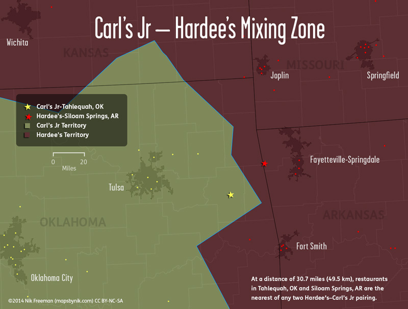
The region where the two brands come closest to each other is in northeast Oklahoma and northwest Arkansas (see the “Mixing Zone” map). At 30.7 miles (49.5 km) apart, the two closest restaurants of each chain are located in Siloam Springs, AR (Hardee’s) and Tahlequah, OK, inside the Cherokee Nation (Carl’s Jr). As sometimes the company airs the same commercial, but with a different name at the end, the advertising in this region must sometimes get confusing and must be the stuff of a brand manager’s nightmare.
Despite being under the same umbrella for 17 years, the service areas of two chains remains distinct and separate. Neither chain has permanently encroached into the other’s territory, creating a sharp east-west division. And I love the emphasis that this map places on that divide. The distribution of the two chains, as well as their corporate history, offer a near perfect illustration of how physical geography can guide economic activity and human settlement patterns.
In the west, Carl’s Jr restaurants are concentrated in urban and suburban areas. Ninety-five percent of the chain’s locations are found inside a Census Bureau designated urban area or urban cluster (defined by population density). And the typical Carl’s Jr location has 14,652 people living within a one-mile radius.
By comparison, only eighty-three percent of Hardee’s, a business founded to serve more rural populations, are located in urban areas or clusters. And those areas are generally smaller. At a one-mile radius, the typical Hardee’s restaurant is surrounded by only 4036 people.
These characteristics are the results of a half-century trajectory for each chain, where different opportunities were presented to them by the continental landscape. For Carl’s Jr, those opportunities were found in the boom times and population growth of the comparatively few habitable places in the American West. In Hardee’s case, opportunity was found among the smaller towns spread out among the eastern geography that supported their existence.
::
The eastern half of the United States is privileged to be situated with attributes advantageous to population growth and economic development. The combination of fertile soils, abundant precipitation, thousands of miles of navigable rivers, and relatively flat terrain on a continental scale provide tremendous support for widespread habitable living. As the nation grew, these physical traits allowed and encouraged the population to establish vast agricultural holdings, with small settlements peppered throughout as local hubs of economic activity. By the 1960s, these towns represented a large untapped market for Hardee’s to target.
As the Hardee’s franchise grew from its home in Rocky Mount, NC (population 32,147 in 1960), the chain deliberately set up shops in those smaller towns and rural areas. American car culture had been spreading east from its roots in Southern California during the previous decade. Drive-in fast food restaurants followed shortly, becoming common sights in the larger urban and growing suburban areas of the country. Less populated places, however, were excluded from the initial industry boom, and Hardee’s saw the opportunity to bring the fast food experience to them.
Carl’s Jr, on the other hand, got its start in Anaheim and Los Angeles, amid the post-war prosperity and growth that allowed the automobile’s dominance to alter the landscape. Massive engineering projects had brought water to the deserts of SoCal. At first, there were farmers, but as more people moved to the region, drawn by the tremendous boom times, those farms became suburbs. By the early 1950s, Anaheim was the fastest-growing city in one of the fastest-growing regions in the country. And pioneers like Carl’s Jr, McDonald’s and Taco Bell were there to kick start the industry.
But even the grandest irrigation schemes and engineering ingenuity can’t completely overcome nature. There’s only so much water to spread around before the beds run dry and only so much land to expand into before mountains start getting in the way.
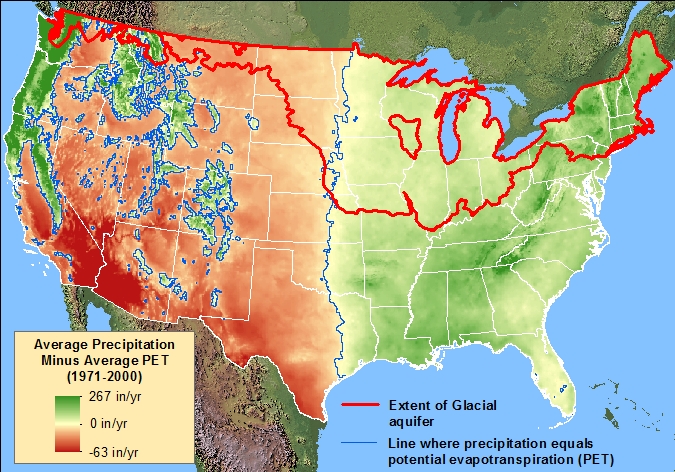
Green areas on this map from USGS receive more precipitation than the landscape can use.
Red areas demand more precipitation than is provided by the atmosphere.
Beyond the rough terrain, one of the principle factors affecting the west is the lack of water compared to the east. Evapotranspiration is the measurement of the amount of water that travels from the surface of the planet into the atmosphere. West of about 96.4 degrees longitude, evapotranspiration begins to outweigh precipitation for expansive stretches of the country. More water leaves the earth than is provided by the atmosphere, making agriculture more difficult than in the east. The arid conditions, combined with the lack of major rivers and the numerous deserts and mountain ranges, means that the types of settlement patterns seen in the east simply are not, and will likely never be, found in the west.
This assessment is backed up by statistics from the Census Bureau. As of the 2010 count, 13,186 Census-defined places east of 96.4 degrees had a population of less than 2500. Those 13,186 places were home to 10,298,685 people in total. West of that meridian however, 6046 places were home to only 3,657,049 people. Not only does the west have fewer small towns, those towns support smaller populations on average.
From this data, it’s clear that the Hardee’s approach would not have worked as well in the west. Fewer small towns and smaller populations make them less attractive options for business expansion. In spite of millennia of indigenous habitation, 500+ years of European colonization, and more than a century of U.S. Homestead Acts (which essentially gave away land to settlers), the west is so generally hostile to survival that populations tend to be more densely clustered in the relatively few places where people can live. Thus we see that the growth of the Carl’s Jr franchise occurred in those clusters.
::
The difference in geography didn’t just affect the distribution patterns of the restaurants; it also played a factor in the merger of the two companies. Why did CKE choose to maintain two separate identities? Why hadn’t Hardee’s locations simply become Carl’s Jr during the takeover?
That was plan when CKE bought Hardee’s in 1997. The company wanted to compete nationally with Wendy’s, Burger King and McDonald’s under the Carl’s name. Carl’s Jr existed in the west and Hardee’s had locations in the east and the midwest. On the map, it looked like a perfect marriage, a fast way to expand from coast to coast. Had all Hardee’s restaurants been converted, Carl’s Jr would have indeed become the fourth-largest restaurant chain in the country.
Alas, these grand visions were not to be. Opposition to the changeover was strong. Hardee’s executives, franchise owners and customers balked. The handful of eastern test locations eventually reverted to the Hardee’s name. And of the few outright conversions were that were made, lasting success was limited to a few locales in the west (Oklahoma in particular took to the changes, possibly explaining the bulge in Carl’s territory around Tulsa).
By 2001, the parent company had settled on a hybrid approach (which continues in 2015). Elements of Carl’s Jr (such as certain burgers) were sent east and the long-time icon of Carl’s Jr—that happy little star—was also gifted to Hardee’s as part of a rebranding campaign. From that time forward, the restaurants had two different names, but shared one logo. In the meantime, parts of Hardee’s menu (such as its breakfast items) went packing west.
The conversions didn’t stick, in part, because the culture surrounding Carl’s Jr didn’t mesh well with Hardee’s branding. By the nature of its rural, small town focus, Hardee’s had earned a following among an older, hard-working, blue-collar crowd with “folksy” values. Despite its troubles in the 90s, the Hardee’s brand still held value to its customers.
Carl’s Jr, as a product of Southern California, reflected a younger, more hip, more urban attitude. When CKE attempted to swap the down-home hangout for the unknown upscale joint with the awkward name, the company risked losing a dedicated customer base, one that had stuck with Hardee’s through the hard times.
It took a few years of growing pains to settle on a working model, but by many accounts, this match made on the map continues to succeed 18 years later.
::
I made this map to settle a curiosity I’ve had for more than a decade, from the time I first spotted a Carl’s Jr location during a cross-country drive in 2002. As I travelled westward through Texas, I remember distinctly the restaurant’s logo catching my attention.
At the time, Hardee’s was in the midst of its revitalization and recovery following a disastrous turn in the 1990s. That star had been near the center of the recent campaign to turn the store around. Nearly everything in the South that said “Hardee’s” had the star next to it.
To my growing perplexity, more restaurants with more smiling stars greeted me in town after town, as I continued along Interstates 10 and 20. In my mind, the star belonged to Hardee’s (it had even been called the “Hardee’s Star” in recent ads). What was this other restaurant with the funky name doing with its logo?
It wasn’t until much later (in those pre-Wikipedia days) that I learned the story of the purchase and merger of the two companies. When I found location data for the restaurants last year, I finally put to rest my questions about where one chain ended and the other began.
Full disclosure: I haven’t been to Hardee’s since the 1990s and have never stepped foot inside a Carl’s Jr.
©Nik Freeman (mapsbynik.com) 2014-2015
Creative Commons Attribution-NonCommercial-ShareAlike
County geography from U.S. Census Bureau
Restaurant locations from poi-factory.com
*Hardee’s locations as of June 2014
*Carl’s Jr locations as of January 2014
Made with Tilemill and Adobe Creative Suite
USGS National Atlas Equal Area Projection