#wafflebelt


Waffle House by Latitude
After the seriousness of the Nobody Lives Here map, we’re back to the silliness of Waffle House. I promised more visualizations of WaHo geography, and here I deliver.
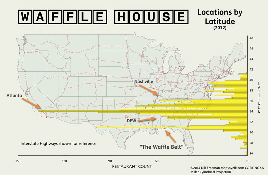
This graphic shows a mash-up of two visualization types: a map and a bar chart. The concept is similar to Bill Rankin’s population histograms, which tabulate population counts by latitude or longitude. Here, Waffle House restaurant locations are counted by their latitude, grouped into segments of 0.25 degrees.
WaHo’s status as primarily a southern institution is well-established. And the results here match that expectation, with only a handful of restaurants to be found north of the Mason-Dixon line. But these results also emphasize how Waffle House distribution is more a phenomenon of the Deep South. Of the 1606 locations in my (2012) data set, 66% of them are located south of the Georgia-Tennessee border (35° 59’ N).
Looking at the longest bars, we see the Atlanta metro area dominating again, just as it did on the 3d Density Map. The first, third and fourth-longest bars pass straight through the ATL and its environs (Athens helps a bit too). There’s another, smaller concentration near 33° N that we can attribute to locations in Dallas-Fort Worth. Nashville is also responsible for a relatively long bar.
The takeaway from this graphic for me though, is the bar that passes along the Gulf Coast (as well as the two smaller bars on either side). It’s the second-longest bar on the page, yet no single city can account for it. Instead, it’s mostly a string of locations tied together by one common element: Interstate 10.
The Gulf Coast between Jacksonville and Houston has 78 Waffle House locations within one mile of I-10 (and an additional 9 along the I-12 bypass of New Orleans). Plus, many of the towns along that route have restaurants near the coast. US 90 between Mobile and LaFayette adds an additional 19 locations.
Given the linear spread of Waffle House locations along the Gulf Coast, I’m tempted to coin the term “Waffle Belt” to describe that region. Actually, that doesn’t sound too bad.
I hereby christen the Gulf Coast from Houston to Jacksonville as The Waffle Belt. May its syrup always be heated and its batter forever fluffy.
::
Map Notes
- I chose the Miller Cylindrical projection for this map because I needed the parallels to be, well, parallel. Can’t have curved latitudes with straight bars. I also wanted to minimize the area distortion in the northern states, so that ruled Mercator right out.
- As with the 3D map, the Waffle House location data is my own creation made by geocoding addresses with Google and MapQuest.
- Made with QGIS, Photoshop, Apple Numbers and my own Python script
- Highway data from National Highway Planning Network, U.S. Dept. of Transportation
Annotated version with call-outs
Post link