#wafflehouse


Smothered, diced, peppered, capped.
❤️ Waffle House

First #wafflehouse of the No Sleep ‘Til @wafflehouseofficial #tour with @ikillya and @yesterdays_saints
Post link

Tonight in Queens, NYC at Gussy’s Bar with @ikillya #metal #tour #wafflehouse @whatsintheb0x @skullandbones_nyc https://www.facebook.com/events/1661692924076390/ (at GUSSY’S BAR)
Post link
")

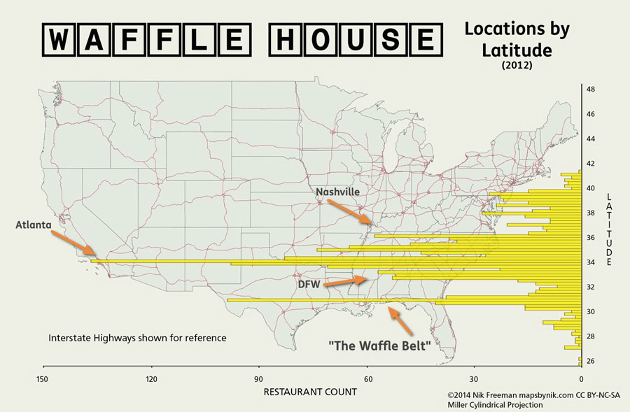
Waffle House by Latitude
After the seriousness of the Nobody Lives Here map, we’re back to the silliness of Waffle House. I promised more visualizations of WaHo geography, and here I deliver.
This graphic shows a mash-up of two visualization types: a map and a bar chart. The concept is similar to Bill Rankin’s population histograms, which tabulate population counts by latitude or longitude. Here, Waffle House restaurant locations are counted by their latitude, grouped into segments of 0.25 degrees.
WaHo’s status as primarily a southern institution is well-established. And the results here match that expectation, with only a handful of restaurants to be found north of the Mason-Dixon line. But these results also emphasize how Waffle House distribution is more a phenomenon of the Deep South. Of the 1606 locations in my (2012) data set, 66% of them are located south of the Georgia-Tennessee border (35° 59’ N).
Looking at the longest bars, we see the Atlanta metro area dominating again, just as it did on the 3d Density Map. The first, third and fourth-longest bars pass straight through the ATL and its environs (Athens helps a bit too). There’s another, smaller concentration near 33° N that we can attribute to locations in Dallas-Fort Worth. Nashville is also responsible for a relatively long bar.
The takeaway from this graphic for me though, is the bar that passes along the Gulf Coast (as well as the two smaller bars on either side). It’s the second-longest bar on the page, yet no single city can account for it. Instead, it’s mostly a string of locations tied together by one common element: Interstate 10.
The Gulf Coast between Jacksonville and Houston has 78 Waffle House locations within one mile of I-10 (and an additional 9 along the I-12 bypass of New Orleans). Plus, many of the towns along that route have restaurants near the coast. US 90 between Mobile and LaFayette adds an additional 19 locations.
Given the linear spread of Waffle House locations along the Gulf Coast, I’m tempted to coin the term “Waffle Belt” to describe that region. Actually, that doesn’t sound too bad.
I hereby christen the Gulf Coast from Houston to Jacksonville as The Waffle Belt. May its syrup always be heated and its batter forever fluffy.
::
Map Notes
- I chose the Miller Cylindrical projection for this map because I needed the parallels to be, well, parallel. Can’t have curved latitudes with straight bars. I also wanted to minimize the area distortion in the northern states, so that ruled Mercator right out.
- As with the 3D map, the Waffle House location data is my own creation made by geocoding addresses with Google and MapQuest.
- Made with QGIS, Photoshop, Apple Numbers and my own Python script
- Highway data from National Highway Planning Network, U.S. Dept. of Transportation
Annotated version with call-outs
Post link

Waffle House Density by Quad
The map shown here is a truly quick-and-dirty visualization of the distribution and density of Waffle House locations as of summer 2012. It started as a way for me to play with 3D in Google Earth, but that giant spike in Atlanta was interesting enough that I thought it worth sharing.
The rectangles represent USGS 30x60 minute (1:100,000) map quad boundaries and the height extrusions are proportional to the number of Waffle House locations found within that quad.
Map Observations
Atlanta, Georgia is the clear standout on the map. Its quad contains 132 locations. Immediately north of Atlanta, the Cartersville, Georgia quad is next highest on the list with 45 locations. These are followed by Greenville, SC (34), Athens, GA (29) and Fort Worth, TX (25).
The Atlanta metro area’s dominance on the map is not unexpected, though its scale is somewhat surprising. The first Waffle House restaurant opened in the Avondale Estates, an inner Atlanta suburb, in 1955 and the company is headquartered in Norcross, another nearby suburb.
Waffle House has a reputation for omnipresence in the south and that seems especially true in the Atlanta area. The Atlanta quad has nearly three times the number of restaurants as the next highest. And that next highest quad, Cartersville, actually contains most of the north Atlanta metro area. Atlanta is home to a full eleven percent of WaHo locations.
Beyond Atlanta, the map shows that Waffle House is indeed primarily a southern phenomenon with a few surprising and unusual patterns in a couple metro areas. Phoenix and Denver have a handful of locations, but there are none in California. Amarillo has five locations, but San Antonio has zero despite being a much larger city at the junction of two major interstates.
Top 21 Quads
| Quad Name | Number of Locations |
|---|---|
| Atlanta (GA) | 132 |
| Cartersville (GA) | 45this quad includes the N. ATL suburbs |
| Greenville (SC) | 34 |
| Athens (GA) | 29 |
| Fort Worth (TX) | 25 |
| Nashville (TN) | 24 |
| Griffin (GA) | 23 |
| Commerce (GA/SC) | 20 |
| Mobile (AL/MS) | 20 |
| Louisville (KY/IN) | 18 |
| Dallas (TX) | 18 |
| Macon (GA) | 18 |
| Bay Minette (AL/FL) | 18 |
| Charlotte (NC/SC) | 17 |
| Aiken (SC/GA) | 17 |
| Jackson (MS/LA) | 17 |
| Raleigh (NC) | 16 |
| Little Rock (AR) | 16 |
| Gulfport (MS/LA) | 16 |
| Biloxi (MS/AL) | 16 |
| Pensacola (FL/AL) | 16 |
Background
This visualization stems from my irrational, lifelong infatuation with Waffle House, the always-open dive joint that manages to provide a low-cost, consistently-satisfying breakfast meal at its 1600+ locations. It’s one product of a casual analysis I started a few years ago to find WaHo locations that were unexpectedly close to each other, and it snowballed into a bunch of different depictions of Waffle House geography. I recently stumbled on these old files and will (eventually) be sharing them as I get them cleaned up and presentable.
Additional Notes
Grouping by USGS 1:100,000 quads was an attractive option for this data for a couple of reasons:
- The quads are continuous across the entire USA. There are no gaps, so every Waffle House location falls within one quad.
- Quad boundaries are static. They will not have changed if I update the data.
- Quads are named for the area they cover, making it easy to discuss particular locations.
- At approximately 2392 square miles each, quads are a nice “bucket” size for tabulating this kind of location data meaningfully.
Restaurant addresses were taken from wafflehouse.com and geocoded with services from both Google and MapQuest. Discrepancies were rectified by hand. As a set, the locations are generally accurate but no given restaurant is guaranteed to be correct.
Post link