The ancient Aliki quarry at Thasos. Though a Greek island in the northern Aegean Sea, the area was once geographically part of Macedonia.
An impressive ancient quarry partially submerged in the sea: The Aliki quarry on the southern shores of the island of Thassos (Greece) symbolises ancient stone work and trade, with the Mediterranean as the connecting link since time immemorial.
It also symbolises how quarrying may shape the landscape over the centuries. A coarse-grained, white calcitic marble, Aliki was a highly prized stone in Antiquity, exported throughout the Eastern Mediterranean to places such as Thessalonica, Delphi, Ostia, Rome, Ephesos, Antioch and Cyrenaica.
Extraction may have started in the 6th Century BC, and it ceased more than a thousand years later in the early 7th Century, perhaps due to an earthquake. The ancient quarrying techniques are well displayed by the bay of Aliki and the nearby shorelines of the island, and the quarries are easily accessible for tourists. (quarryscapes)
On a closer observation, Roman wedge holes as well as marks from picks and chisels can still be seen.
Making the rounds on the internet is a story about William Gadoury, a 15 year old boy from Quebec who claims to have found a lost Maya city in the jungles of Yucatan using a combination of constellation figures from the Codex Madrid and satellite imagery from Google Earth and other space agencies. While I applaud the boy’s interest in Maya archaeology and effort in helping to discover and identify settlements using remote sensing, I think we need take a step back and assess the claim of a lost city being discovered.
In these news articles Gadoury says he used Maya constellations from the Codex Madrid to create an overlay on the Yucatan peninsula to see whether or not sites lined up. He claims to have matched over 100 Maya cities to constellations, but in one of the constellation points is missing a site which he claims to have found through satellite imagery. What’s particularly lacking in these articles is Gadoury’s methodology. How does he determine the scale and orientation of the constellation overlays? Are all of the sites that match a constellation contemporaneous to one another? Does he reuse any of these sites for other constellations or is it a one and done situation? How does he know that one site was used just for that one constellation and not another? How does he suggest a group of competing kings from various city-states working together to build cities in accordance with these constellations? Where is the proof of this 86m high pyramid? And is he aware just how many Maya sites there are and how easy it would be to play with an overlay until sites lined up?
If we look to MayaMap.org we can see just how many Maya sites there are scattered around not only the Yucatan, but Belize, Guatemala, Honduras, and El Salvador.
There are very many large and small sites. So it would be very easy to match sites up with constellations by changing the scale and orientation. And if we look at the map we can see that yes, there are gaps, but that doesn’t mean that the area is completely unknown and that there are lost cities waiting to be found.
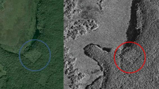
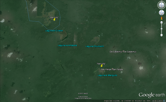
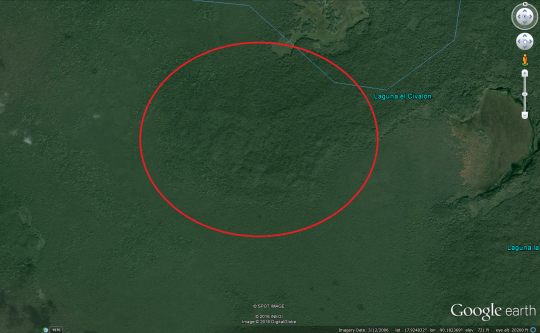
Based off the existing news articles showing the satellite imagery and a map showing the general location of this “lost” city, I’ve found that the location is on the shore of Laguna el Civalon. The square that is being touted as a structure looks very much like a cleared field for farming butting right up against the shore of the lake. Thomas Garrison, an anthropologist at USC Dornsife and an expert in remote sensing, also confirmed my assumption in this article by Gizmodo.
That being said, there are suspicious clusters of bumps in the satellite imagery which could be natural or artificial. Is this the “lost” city or is it something else?
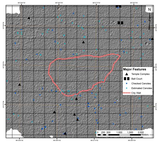
Searching through Google Scholar has not produced any publication of archaeological work done in this area. However, what does come up are articles and books by Grant D. Jones, a historian who writes prolifically about the colonial Maya with a focus on the Itza Maya whose kingdom was conquered by the Spanish in 1697. In Jones’ work (1998) he mentions the site of Chunpich, a Kejach settlement east of Laguna el Civalon and Laguna Amapola. Chunpich consisted of three dispersed hamlets, but Jones makes little mention as to what the architecture or size of the hamlets was like. While these bumps may not be Chunpich, they may be a nearby settlements located on the other side of the shore that Jones believes must also have been inhabited.
What does this truly mean? Well, the Maya region was very densely populated. You would be hard pressed to go 10 meters and not run into something in the Lowlands. Even in northern Yucatan you are confronted with densely populated centers that spill out of their city walls as is the case of Mayapan.
It would be unsurprising if something was actually in the area. But does that mean there a lost city? Or an 86m high pyramid lurking in the jungle? Or that the Maya planned their cities according to constellations? Most likely that is a no. Cities and settlements were placed near resources that could be exploited like lacustrine or mineral resources. Cities were also placed near sources of fresh water so finding settlements near these lakes is really unsurprising. The other side of it is that it would be extremely difficult to get a group of competing kings from rival city-states and territories to band together to build cities according to constellations. This sort of overarching political structure is just not seen in the Maya region. David Stuart, a prominent Maya archaeologist who also made a comment in the Gizmodo article, has spent his entire career fighting against the notion that the Maya were a stargazing society that used the stars to guide their every action. So planning multiple cities to form a constellation on the ground just doesn’t add up.
The saddest part of this whole incident is what is going to happen to William Gadoury. He’s obviously enthusiastic on learning about the Maya and bringing new ideas to the table. It’s just unfortunate that a Maya expert wasn’t consulted before the media decided to exploit this poor boy for a junk science article to get ratings and clicks. Even an expert on remote sensing could have told Gadoury that the square featured in all of these articles was a field and avoided this whole mess. It is my hope that Gadoury isn’t discouraged that his claim doesn’t hold up and instead redoubles his efforts as he hopefully finishes high school and goes on to university. Unfortunately academia can be harsh when presented with extraordinary claims lacking extraordinary evidence.
This is you should take any claims about scientific or historical discoveries with several grains of salt.
We visited the Pictish Iron Age-style hillfort ‘Castle Law’ near Forgandenny. It’s walls at the top were cleared by Victorian archaeologists and remain very distinct and visible to this day. So we were really intrigued and wanted to come for a visit and a hillfort tour. There was a lot to see and being able to get a bird’s-eye perspective with the drone was priceless. I hope you will enjoy it as much as we have!
This Iron Age-style hillfort has been excavated in Victorian times and since then the walls at the top have been exposed, creating this fascinating pattern. From the ground all we could see was parallel lines, but from the air this hillfort truly comes to life. It is a timber-laced hillfort, just like the nearby Castlelaw near Abernethy, a technique which originated in Switzerland according to some archaeologists and may reflect an influx of incomers to the British Isles from the continent. There’s a full hillfort tour up on my channel.
We visited two Iron Age hillforts near Newburgh, Fife: Norman’s Law, un-excavated, but well-preserved in its features; and Glenduckie Hill, excavated, but overgrown with plants that conceal its features. They couldn’t be any more different. We discuss the appearance and history of the hillforts in this video. I also used a drone to get a bird’s eye perspective. So come and explore these hillforts with us!
This is a well-preserved Iron Age hillfort, which was so much fun to explore. There is a total of 3 walls, each becoming larger in diameter. So this must have been a large and important fort at one point in time. The top and innermost part of the hillfort still has ample remains of the 3 to 4 meters-thick wall that once protected it. This fort is close to Newburgh in Fife and lies along the Fife Coastal Path. For the most part, Fife can be associated with the Pictish tribe of the Venicones, the most likely candidates to have inhabited this fort. From the top you get a great view towards the River Tay and the Scottish Highlands in the North. It’s very likely that on the other side of the river the tribal territory of the Caledonians began. To the North-East you can see Dundee, which coils around Dundee Law, another ancient hillfort.
All of the snow, except for the mountain tops, has melted and Spring has begun. It’s always nice to walk through an old forest up to the top of this hillfort and see these cairns, which have been built during the Victorian era. Rather than following the path, we followed an old wall, which we knew would lead us straight to the top. The forest is a bog at this time of the year, but this is the most fun I had in while. I felt invigorated. Forest bathing is a real thing with real effects on the body, psyche and soul.
This is a really nice review of the methods, scope and major discoveries of underwater archaeology across the world. It is entirely about the archaeology of places which used to be above water - this isn’t shipwrecks, but places like Dunwich orDoggerland. It can be a little dry, but kept my interest for all of it except some parts on the legal background (which is probably more me than the book tbf).
I think one of the best points made is that underwater and onshore archaeology need to be integrated - to understand a landscape they have to be understood together, not as separate sites. Unfortunately, the tidal area is one of the most difficult places to deal with archaeologically - but that doesn’t invalidate the need to integrate.
This is a book which definitely takes one side in a very polarised issue, regarding both the identity and ownership of the skeleton now known as Kennewick Man. It happens that since publication it has proved to be right as far as identity is concerned (more modern DNA analysis has shown that the skeleton is most closely related to modern Native American populations - wikipedia has a good update). As to the ownership - should scientists or local Native communities get to decide what happens with ancient human remains? This book is in favour of native communities getting to make the choice, making the very good point that museums had ancient American skeletons in storage for decades without making any study of them - they only suddenly became interested in actually getting down to doing any science when Native communities started demanding them back for burial.
I found this both highly readable, and that I am very much inclined to take the author’s view on the controversy. For balance, one of the anthropologists who was involved in the discovery and took the totally opposite view wrote a book at around the same time - Ancient Encounters: Kennewick Man and the First Americans - if you want to read the other side.
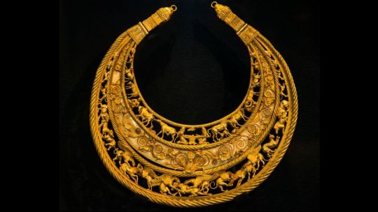
Russian soldiers have reportedly stolen gold Scythian artifacts dating back about 2,300 years from the Melitopol Museum of Local History in Ukraine. Additionally, there are reports that a museum staff member is currently being held by the Russian military.
The Scythians, culturally related groups of nomadic pastoralists and formidable warriors, thrived across Eurasia between roughly 800 B.C. and A.D. 300 and crafted many beautiful artifacts out of gold.
Melitopol, located in southeastern Ukraine, has been occupied by the Russian military since March 1, according to news reports. Since the Russians started their invasion of Ukraine on Feb. 24, they have captured large swaths of territory in the eastern and southern parts of the country. However, their attempts to take the capital city of Kyiv have failed. Read more.
“Ramsom of Hector’s body”, Roman Villa del Tellaro, Noto (Sicily) IV century aD. Odysseus, Achilles and Diomedes are identified by inscription in Greek. Priam’s figure is lost, while of Hector remain only the legs.
“Nefertiti Bust on display (1963)at the Berlin-Dahlem Museum, West-Berlin, Germany during a visit by the Vice-President of Cyprus (image by Ludwig Wegmann via Wikimedia, originally provided by the German Federal Archive)”
Krater from the Geometric Period, terracotta, ca. 750-730BC, Greece.
Monumental vases like this one were used as grave markers during the Geometric Period (kraters for men and amphoras for women). On the largest part of the vase is depicted a scene called “prothêsis” in which the deceased is laid on a bier and surrounded by mourners. The mourners are represented with the hands on their heads because it symbolises their wailing. The charriots and shields depicted under the prothêsis are probably there to show that the deceased had a powerful ancestry.
Queen Tiye’s head with a feathered crown from the Amarna Period (18th dynasty), yew wood, lapis lazuli, silver, gold and faience, ca. 1355 B.C, Egypt.
Tiye was the spouse of Amenhotep III, mother of Akhenaten and grandmother of Tutankhamun. She is represented with great realism and we can see her very distinctive features in the typical Amarnian style.
This head has had two different hairstyles over time and they have been modified for unknown reasons. The original one was probably a khat,which was a head cloth worn by the nobility. We can still see traces of its ornaments on Tiye’s forehead where the golden uraeus were attached. The khat let the ears bare and that’s why the queen is depicted wearing golden earrings. Interestingly, the khat was actually reserved to goddesses: Tiye and Nefertiti are the only mortals to have ever been represented wearing one.
The second hairstyle is the one we can still see today. For unknown reasons the first hairstyle was destroyed and its remnants were covered by a linen wig that hid the earrings.
This head was probably meant to be attached to a body that has not been discovered.
Photo by Steven Zucker / Courtesy of the Egyptian Museum of Berlin


, yew wood, lapis lazu")