#rare maps
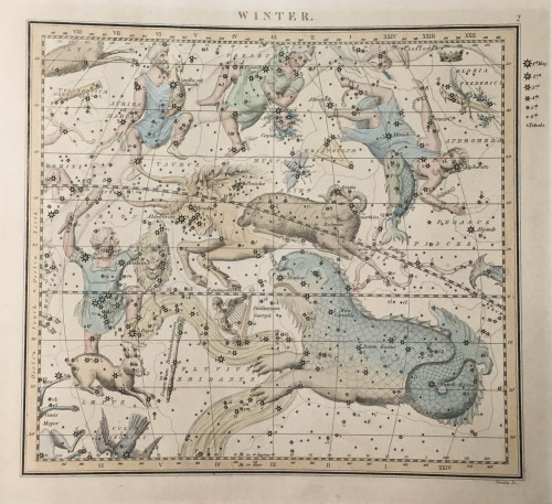
Happy Winter Solstice! This map shows winter constellations visible in Great Britain. Here are some of the featured constellations along with their affiliations to Greek mythology:
Cetus the whale (Cetus is a sea monster killed by Perseus)
Andromeda, who is in chains (she is chained to a rock to be eaten by Cetus, but she is saved by Perseus, her future husband)
Perseus, holding Medusa’s head (he is the son of Zeus and Danaë, the slayer of Medusa and Cetus, and the husband of Andromeda)
Auriga, holding a goat (he is often a charioteer)
Orion the hunter, holding a lion skin (he is the son of Neptune and is placed in the stars by Diana after she accidentally kills him)
Image from:
James Middleton’s A celestial atlas containing maps of all the constellations visible in Great Britain… London: Whittaker and Co. ; Norwich: Jarrold and Sons, 1846?
Call Number: QB65 .M46 1846
Catalog record: https://bit.ly/2BygdW8
Post link
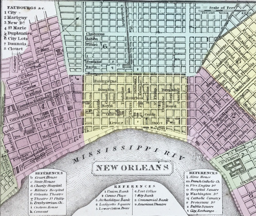
This 1850 map of Louisiana shows canals, roads, and steamboat routes. It includes the distance of steamboat routes from New Orleans to Pittsburgh, Natchitoches, and Balize. (Balize is a historical town that was located at the mouth of the Mississippi River until the 1850s when residents began to move upriver to a settlement called Pilottown, which was near modern-day Venice).
The map was hand colored to show the borders of each parish and the neighborhoods of New Orleans.
Images from:
A new map of Louisiana… Philadelphia : Published by Thomas, Cowperthwait & Co., 1850.
Call number: G3200 DRAWER 1 MAP 40
Catalog record: https://bit.ly/3Dw1I2T
Post link
This map shows the Mississippi, Red, and Black Rivers according to Jacques-Nicolas Bellin’s observations during his role as a hydrographic engineer for the French government. It is included in his 1764 work, Petit Atlas Maritime, which contains over 500 maps of coasts and port cities.
Here is a translation of the map’s “Remarques sur la Riviere Rouge” (Remarks on the Red River).
The Red River is very difficult to navigate upriver, especially in low waters, but in high waters, we pass everywhere. Along its banks, there are a lot of lakes and wetlands. This river is full of crocodiles and fish. Its banks are abundant in wild animals such as oxen [or buffalo], bears, tigers, wolves, stags, and deer. There is also a quantity of game such as turkeys, geese, bustards, swans, and ducks of all species. All sorts of wild fruit trees and vine stocks that contain muscat [grapes] and other grapes.
Images from: Bellin, Jacques Nicolas. Suite du cours du fleuve St. Louis : depuis la rivière d'Iberville jusq'à celle des Yasous, et les parties connues de la Rivière Rouge et la Rivière Noire. Paris, 1764.
Call Number: G3200 DRAWER 1 MAP 39
Catalog Record: https://bit.ly/30rj5Ec
Post link
This view of Frankfurt am Main shows the German city as it existed in the middle of the seventeenth century. In addition to showing the general layout of the city, it also includes a legend that lists notable landmarks. The city center is dominated by the “Prediger Closter,” a Dominican monastery founded in the 13th century. The original building survived until 1944 (when it was destroyed by Allied bombing), although it had not been used for religious purposes since the early 1800s. Also visible is the city’s moat and walls. These fortifications were removed in the early nineteenth century. In place of the walls, the area is now covered by a park.
Images from: Merian, Mattheus. Francofurtum. Frankfurt am Main: Mattheus Merian, ca. 1640.
Call number: G3200 Drawer 3 Map 2
Link to catalog record: https://bit.ly/3c8yfkc
Post link
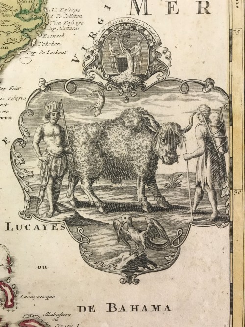
This cartouche, found on an 18th century map of North America, is representative of European conceptions of the New World. It displays Native people side-by-side with wildlife, evoking the feeling of an untamed continent and blurring the distinction between person and animal. The two Native Americans are depicted as an amalgamation of eastern aboriginals in their manner of dress. The animals depicted are similarly vague. The buffalo bears a strong resemblance to forms more familiar to Europeans, namely the humped species of Asia. Also depicted are a possum and ibis. Finally, the cartouche is topped with a depiction of a cornucopia pouring forth its contents. This is the essence of the European idea of the New World: endless riches. The pursuit of gold, furs, arable land, and religious converts drove centuries of bloody expansion that would decimate Native populations, reshape the land, and drive some native fauna to near extinction.
Image from: Homann, Johann Baptist. Amplissimae Regionis Mississipi seu Provinciae Ludovicianae. Norimbergae: Nova tabula edita â Io. Bapt. Homanno, 1720.
Call number: G3200 DRAWER 2 MAP 6
Catalog record: https://bit.ly/3H2wkMD
Post link


