#northern territory


5 things you didn’t know you could do in the NT
There’s more to the Top End than you think. Picture: Tourism NT. Source: Supplied
THE vast yet beautiful Northern Territory drew more local and international travellers this year than any of the past five.
The National Visitor Survey showed 1.34 million visitors ticked the Territory off their bucket lists, a 14 per cent increase. So what makes this region so special?
Apart from the obvious…


Aboriginal Rock Art - Arnhem Land by Chris Borough
Via Flickr:
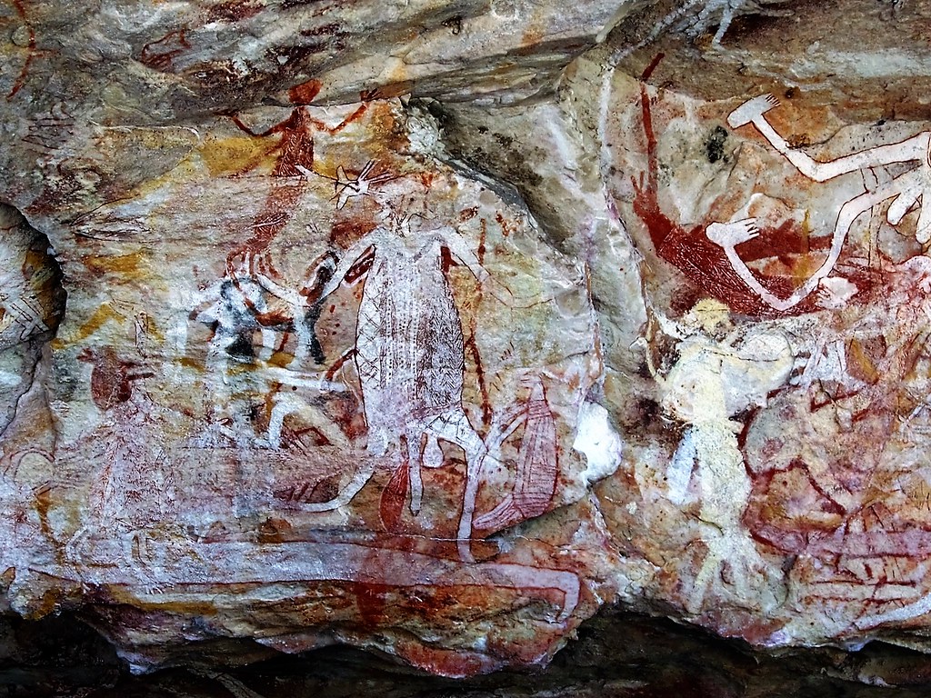
Unbelievable mix of paintings More Arnhem Land images in Album Arnhem Land Without doubt the “Catacombs” at Mount Borradaile in Arnhem Land would be the most memorable place that Australia has to offer. Difficult of access, Davidson’s Lodge at Mount Borradaile has a lease over 700 sq km of wilderness and is only available to a limited number of visitors. The “Catacombs” - located nearby - have been formed in Pre-Cambrian sandstone rocks that have essentially lain unchanged for around 600 million years. The sandstone has been eroded by wind and water creating a massive cave system that is peppered with unbelievable Aboriginal art. Evidence suggests that aboriginal people inhabited these areas 40,000 years ago. The artwork appears to been made after the end of the the last ice age - around 10,000 years ago.
Aboriginal Rock Art - Western Arnhem Land by Chris Borough
Via Flickr:
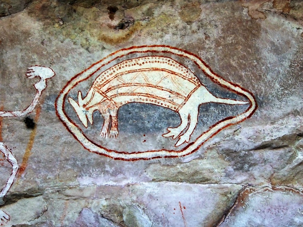
Bandicoot More Arnhem Land images in Album Arnhem Land Without doubt the “Catacombs” at Mount Borradaile in Arnhem Land would be the most memorable place that Australia has to offer. Difficult of access, Davidson’s Lodge at Mount Borradaile has a lease over 700 sq km of wilderness and is only available to a limited number of visitors. The “Catacombs” - located nearby - have been formed in Pre-Cambrian sandstone rocks that have essentially lain unchanged for around 600 million years. The sandstone has been eroded by wind and water creating a massive cave system that is peppered with unbelievable Aboriginal art. Evidence suggests that aboriginal people inhabited these areas 40,000 years ago. The artwork appears to been made after the end of the the last ice age - around 10,000 years ago.
Aboriginal Art - Western Arnhem Land Rainbow Serpent head by Chris Borough
Via Flickr:
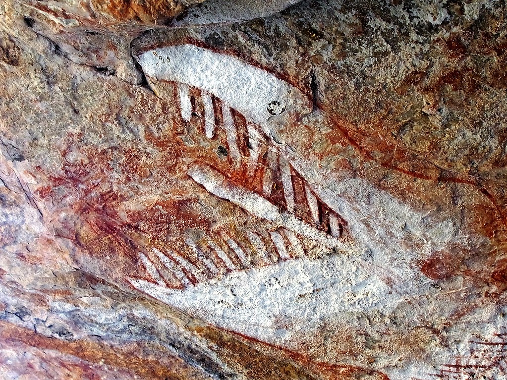
Rainbow Serpent head The following has been sourced from www.barry.warmkessel.com/AUSTR1-3.html The Rainbow Serpent Shelter is an enormous painting of a Serpent. It has a length of 6.1 metres (20 feet), the longest serpent drawing in Australia. Its big head resembles that of a dragon, with rows of fearsome teeth in the jaws. The distance between the tips of the distended jaws is almost a metre. The spine and rib structure of the beast are carefully indicated. The whole composition is beautifully painted, with fine lines of red ochre on a white background. The serpent plays an important role in all major religions, but also in the myths of the region. To Aborigines, they are among the most potent and profound of all rock paintings. In its various guises, the Rainbow Serpents of western Arnhem Land originated from the sea. The scholar Mr. G. Chaloupka believes this Serpent is called ‘Aburga’ painted within the last 1,500 years by the now extinct Amurdak-speaking Malakiri clan. Authors Roberts and Parker write in their book “Ancient Ochres, the Aboriginal Paintings of Mount Borradaile”: “This is a dry, accessible shelter with no signs of habitation, indicating that it was strictly a ceremonial site. There are various habitation shelters in the immediate vicinity. In this particular shelter there is very little art other than the main image, and there have been no images superimposed over any part of it. Clearly, this is testimony to the importance of this painting.” More Arnhem Land images in Album Arnhem Land Without doubt the “Catacombs” at Mount Borradaile in Arnhem Land would be the most memorable place that Australia has to offer. Difficult of access, Davidson’s Lodge at Mount Borradaile has a lease over 700 sq km of wilderness and is only available to a limited number of visitors. The “Catacombs” - located nearby - have been formed in Pre-Cambrian sandstone rocks that have essentially lain unchanged for around 600 million years. The sandstone has been eroded by wind and water creating a massive cave system that is peppered with unbelievable Aboriginal art. Evidence suggests that aboriginal people inhabited these areas 40,000 years ago. The artwork appears to been made after the end of the the last ice age - around 10,000 years ago.


2005: The Ooraminna Anticline seen from 35,000 feet. The wells, Ooraminna-1 and Ooramina-2, found gas but not enough it. Both capped and abandoned.
Post link


2005: Flightpath returning to the UK from Sydney took the 747-800 over some spectacular folding and structures in sediments of the Amadeus Basin, central Australia, particularly the Allambarinja Range. Stratigraphic units from the Australian Stratigraphic Units Database.
Post link


2022: The West MacDonnell Ranges, as photographed with new Mavic 2 Pro drone from Honeymoon Gap. Strike ridges of Heavitree Quartzite (~800Ma) delineate the east-west orientation of the range. They are overlain by the madly-folded formations of the Bitter Springs Group. The ranges were uplifted as part of the Alice Springs Orogeny (500Ma to 300Ma), which was unusual in that it occurred mid-continent as opposed to on a plate boundary.
Post link
 staking out a quartzite pile on Ooraminna Station in the North")
 staking out a quartzite pile on Ooraminna Station in the North")
 staking out a quartzite pile on Ooraminna Station in the North")
 staking out a quartzite pile on Ooraminna Station in the North")
2022: A Brown Falcon (Falco berigora) staking out a quartzite pile on Ooraminna Station in the Northern Territory, near Alice Springs, with a bit of grass caught in his (her?) plumage. Able to be easily distinguish from the similarly-sized Black Kites by the characteristic tear-stripe below the eye. Canon 400mm f5.6 lens again handy here.
Post link
, which are 40km west of")
, which are 40km west of")
, which are 40km west of")
, which are 40km west of")
, which are 40km west of")
, which are 40km west of")
2005: 36 conglomerate domes make up Kata Tjuta (formerly known as The Olgas), which are 40km west of Uluru. These conglomerates are thought to be terrestrial fan deposits from the Ediacaran (550Ma). The ‘Valley Of The Winds’ circuit here is one of Australia’s best walks.
Post link


2022: Cuestas of Carmichael Sandstone lining Larapinta Drive, part of the infamous Mereenie Loop. The Carmichael Sandstone (near the top of the Ordovician) is disconformably overlain by the Mereenie Sandstone (Silurian-Devonian), seen further in the distance. Do not bring your BMW here.
Post link


,")
Emily Kame Kngwarreye (Anmatyerre people, Utopia, The northern territory, Australia. 1910 - 1996), No title,1981, Batik on cotton, 174 x 110 cm.
© Emily Kame Kngwarreye/Copyright Agency, Aboriginal & Torres Strait Islander Art
Post link
Instagram Story #1 My Trip To Darwin


I can show you the world

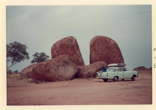
Setting up near the Devil’s Marbles.
Northern Territory
Australia
1969