#weather

 Loving thunder and lightning and finding them intensely beautiful☮ ❤ ॐFollow Us O")
 Loving thunder and lightning and finding them intensely beautiful☮ ❤ ॐFollow Us O")
 Loving thunder and lightning and finding them intensely beautiful☮ ❤ ॐFollow Us O")
 Loving thunder and lightning and finding them intensely beautiful☮ ❤ ॐFollow Us O")
 Loving thunder and lightning and finding them intensely beautiful☮ ❤ ॐFollow Us O")
 Loving thunder and lightning and finding them intensely beautiful☮ ❤ ॐFollow Us O")
 Loving thunder and lightning and finding them intensely beautiful☮ ❤ ॐFollow Us O")

#nature #sky #sun #summer #beach #beautiful #pretty #sunset #sunrise #blue #flowers #night #tree #twilight #clouds #beauty #light #cloudporn #photooftheday #love #green #skylovers #dusk #weather #day #red #iphonesia #mothernature
Post link

Timelapse of an unusual phenomenon called Sea of clouds

Weather - Part 1, by @ajapaneseadventure.
I’m always trying to find new and interesting ways to learn Japanese. However, I’m just a beginner, an adventurer of language! If you spot an error, feel free to point it out, I will try to correct it as soon as possible!


We live in #socal … and you know we are known for our #women #weed #weather . We have Ladies track shorts with a cute potleaf logo to enjoy the beautiful weather in style and comfort ☀️#420 (at Los Angeles, California)
https://www.instagram.com/p/Bm7ScKzFQmI/?utm_source=ig_tumblr_share&igshid=1me2cslu8fgda
Post link


Warm, Humid Conditions, Rain on the Radar
May. 15, 2022
It felt like the summer monsoon season was already getting its start this morning, with electrified OR clouds and warm, humid conditions. The radar and forecast said nothing about rain this morning.
The clouds were the type that occur on the edge of rain systems. I turned the chembuster from northwest facing to straight up to see if rain could be encouraged locally. Then, out of nowhere, rain showed up on the radar for the central coast and inland mountain and desert areas and our skies became cloudier. Interestingly, playing the radar loop, this rain only appeared for a second, while normally it would move through the series of images so you could see where it came from and where it was projected to go.
We did not get rain here, and I wasn’t expecting it, because these were not rain producing clouds. But my analysis was correct that there was activity nearby. We have been working on increasing the reach of the monsoon and hopefully also the duration. This system came up from southwest, so we are beginning to see the change in pattern that occurs in spring and summer.
Incidentally the same two military planes from the other day flew over the mountain valley during the time the rain was on the radar.
Post link


Misty Morning, Snow on the Mountain
May 11, 2022
The thermometer read 32 degrees at 8am PST and low clouds poured over the mountain. This means that the Central Valley also likely was under cloud cover.
Although the forecast made no mention of snow or rain, it was clear from the conditions yesterday that something was brewing. The NWS put up the one cryptic map on May 9 and 10 on their Hanford site that said there would be inclement weather in central California on May 11, but after I posted it on this blog yesterday, they removed it from their site.
There was a dusting of snow on the mountain tops this morning. Today they are admitting to thunderstorms in the Sierras on the Hanford site, but the Weather Channel won’t post this information, saying sunny and a tiny percent chance of rain for this area.
Conditions are very wintery on this spring day, with cold temperatures throughout California and precipitation in the mountains and perhaps other places. If you are in a place with rain (anywhere in the west), maybe you can mention it in the comments, since the weather media won’t do it!
Post link


Chill Air, Pristine Skies
May 10, 2022
It’s been a very cold couple of days with rain in central and northern California and snow in the Sierras. We’re on the outskirts of this storm system and our skies have been electrified with OR clouds and almost no flyers. We’re hearing more of them these days without seeing them, which happens in OR conditions where they can’t use whatever DOR based technology the holographic, silent ones are using. I hypothesize that they have to revert to primitive human technology when OR is too high for them to fly inter-dimensionally.
I can’t get any real weather information anymore, so I can only go based on what I see, and it’s difficult to know what’s happening in other parts of California. I can look at the radar and satellite, which helps, but the forecasts tell me nothing. They have insanely inflated high temperatures and always say sunny, even if the radar shows rain. I found this cryptic map on the NWS Hanford, CA site, which covers our area:
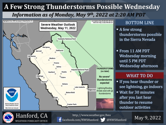
The map tells us there are thunderstorms forecast for the Sierras and a severe weather outlook for central California. At least that’s what I think the color coding means. I can’t find anything about this on the weather forecast. Everywhere is just warm and sunny according to the reports. I have noticed they literally bury the forecasts in weird places now, like if there is a winter weather advisory for our mountain area, they may only report it on a NWS site for San Diego County, 4 hours south of here. They are becoming completely unreliable and I’m sure this is because they have to cry drought despite our incredibly green and healthy environment in California.
Post link

And as Quickly as They Came, They Were Gone
Apr. 28, 2022
Once again, the frenzy of travel was over and there were almost no flyers at all today, plus clear skies. It really changes from one day to the next. It’s not that the trails don’t stick, it’s that they stop flying altogether.
Post link


Exceptional DOR Day
Apr. 27, 2022
This was a day like we don’t see often anymore. Seldom to trails remain in the sky in grid fashion. Something was going on where many of them needed to come through today. Most days recently have been high in OR without many “planes” at all, let alone trails.
Last night there was a freak rain in parts of Southern California. It came out of nowhere and only lasted from about 10pm-12am. It was on the radar all around us but not in the mountains, however they gave us a 63% chance out of nowhere. It was very hard to sleep last night. This is also something that doesn’t happen often anymore, even before rain storms. There was some major DOR push last night like we have not seen in a while.
This evening, it’s clearing up, and even in the afternoon, you can see parts of it starting to clump up. This is the process of transmutation, as OR eventually overtakes the DOR and allows water vapor to be freed from its energetic prison and form into small clouds.
It is noteworthy now when we have a sky like this. This was very common before California became saturated with orgonite, back in 2013 and earlier. However, even with the negative energy apparent in the sky, it was not affecting us here on the ground. Moods were generally unaffected and there were none of the incidents we used to see from humans or animals on days like this.
Post link


Big Snow! Winter Weather Warnings in NorCal, Rain for SoCal
Apr. 21, 2022
I have gathered the best info I can from the impossible to read mainstream news (which insists that “drought persists” no matter how much rain we get) regarding this BIG storm which is already hitting Northern California. The entire west coast is getting rain and snow.
We will see rain overnight in Southern California with snow above 6000 feet. This means rain or wet snow for us here in SoCal mountains, but in the Sierras, you won’t want to be out and about! There will be as much as 4 feet of snow in some places. Add this to last week’s 3 feet in the Sierras!
Currently we are experiencing cold, high OR conditions in Southern California, with winds from the west. We do not have any weather warnings. In Northern California the National Weather Service has issued winter storm warnings and even tornado watches out of the NWS Sacramento.
Post link


High OR Before the Rain & Show
Apr. 19, 2022
It’s been a high OR day as a storm approaches. Many parts of California are already getting rain and snow. The Sierras received 3 feet of snow in the past week!
There is a winter storm warning in effect for North Central California for the next 3 days. The National Weather Service says, “A strong late season storm will bring heavy snow to the southern Cascades and northern Sierra above 5000 feet late Wednesday through Friday morning.” Southern California will be getting rain on Thursday night into Friday, with snow in the mountains.
This has been a very wet winter and spring. It’s also been very cold in California and throughout the west. Last week a record was set in the Tri-Cities area of Washington state, with the latest recorded snowfall in the year. On April 11, 2 inches of snow fell, beating the previous record of April 1, set in 1935. This is an area that has been heavily gifted in the past two years by two different orgonite gifters.
Today also is our 8th anniversary of orgonite making. We made our first batch and watched the sky clear over LA on April 19, 2014. We have come a long way since then, with a much deeper understanding of the energetic war on Earth and the amazing impact we can make on restoring our climate using orgonite.
Post link


Clouds Leap Free!
Apr. 18, 2022
Notice how the crafts’ trails cut out where the clouds spiral upward. That is orgone energy at work in the atmosphere.
Post link
