Sound map of natural conditions of the United States by the National Park Service, estimating how places would sound naturally, without human influence.
The trend is higher sound levels in wetter areas with more vegetation. This is due to the sounds of wind blowing through vegetation, flowing water, and more animals (especially birds and frogs) vocalizing in more fertile locations.
You can look at higher res maps here and also see the sound map of existing condtions.
Top Shot features the photo with the most votes from the previous day’s Daily Dozen, 12 photos selected by the Your Shot editors. The photo our community has voted as their favorite is showcased on the @natgeoyourshot Instagram account. Click here to vote for tomorrow’s Top Shot.
“We witnessed a beautiful storm one evening while visiting Glacier National Park,” writes Your Shot photographer Beth Mancuso. “At first, a double rainbow appeared and then as the rainbow began to fade mammatus clouds emerged. It was one of the most beautiful sites I have ever seen!” Photograph by Beth Mancuso
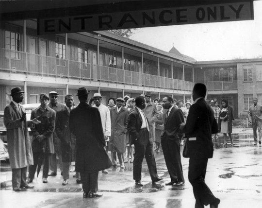
The A.G. Gaston Motel opened in 1954, built by prominent African American businessman and entrepreneur Arthur George Gaston. As a fixture of black businesses in Birmingham, Alabama, the motel was the choice for headquarters of the local civil rights campaign that shaped the city and the nation in 1963.
In Birmingham, the Alabama Christian Movement for Human Rights (ACMHR), founded by Reverend Fred Shuttlesworth in 1956, was key in organizing resistance to segregation and discrimination within the city. Encouraged by Rev. Shuttlesworth, Dr. Martin Luther King, Jr. and members of the Southern Christian Leadership Conference (SCLC) joined forces with other civil rights figures in Birmingham in 1962.
Leaders from the SCLC took up residence in the A.G. Gaston Motel from April through May of 1963, which became the focus of the Birmingham Campaign planning activities. The hotel was the site of constant activity associated with the campaign, and meetings and press conferences held regularly within the courtyard were extensively documented and broadcast by journalists.
Martin Luther King, Jr. and others outside Gaston Motel in 1963 (Birmingham, Ala. Police Department Surveillance Files, 1947-1980. Collection 1125, Archives Department, Birmingham Public Library).
On May 10, 1963, the A.G. Gaston Motel was the site of the announcement of a compromise between local white business owners, city officials, and civil rights leaders. The truce addressed some of the issues in the original list of demands issued by the Birmingham Campaign. Rather than the originally called for immediate desegregation of lunch counters, restrooms, fitting rooms, and other facilities such as drinking fountains, and the hiring of more black workers, the compromise established a longer timeline to desegregate the city. The negotiations were met by a series of violent attacks, including the tragic bombing of the Sixteenth Street Baptist Church.
Sixteenth Street Baptist Church and Kelly Ingram Park (Historic American Buildings Survey, HABS AL-898, Library of Congress).
Nonetheless, efforts to desegregate the city continued slowly over the following months. These events in Birmingham created significant public pressure that helped lead to the passage of the Civil Rights Act of 1964, signed into law on July 2, 1964, by Lyndon Johnson.
A.G. Gaston modernized and expanded the motel in 1968, adding a supper club and other amenities. Business declined in the 1970s and in 1982 Gaston converted the motel into housing for the elderly, which functioned until 1996.
The City of Birmingham acquired the former motel in 2015 with the plan to incorporate it into the larger Birmingham Civil Rights Historic District. Today, the A.G. Gaston Motel is jointly owned by the National Park Service and the City of Birmingham and is a part of Birmingham Civil Rights National Monument, created to honor the nonviolent protesters that fought against discriminatory state and local laws and practices in the 1950s and 1960s.
Interns, called Associates, are integral to the Olmsted Center for Landscape Preservation team and work under the mentorship of experienced landscape architects, horticulturalists, and planners. Associates engage in an extensive program of trainings, educational opportunities, and field trips to enrich their experience.
These paid internships vary in duration and focus but are typically offered to graduating students and young professionals in landscape architecture, horticulture, historic preservation, history, GIS, or related fields, who seek professional experience in cultural landscape preservation.
These positions are supported through a partnership with the National Council of Preservation Education. For more information about each position, including desired qualifications, compensation and project details, download the full announcements at the link above.
Please send application materials by March 1, 2020.
Army Corps of Engineers Road System Added to the National Register
Crater Lake National Park, Oregon
The Army Corps of Engineers Road System at Crater Lake National Park is among Oregon’s latest entries in the National Register of Historic Places.
The National Park Service accepted the nomination on August 12. NPS staff historian Stephen Mark took the lead in writing the nomination, which centered on a previously little-known effort by the Army Corps in highway engineering and construction that happened from 1910 to 1919 in the park.
The Army Corps of Engineers Road System, a precursor to the historic Rim Drive, is significant for its association with the earliest period of highway engineering in Oregon.
As Stephen Mark describes, “Unlike today’s roads, this system came into being with hand tools, horse power, and a couple of wood-burning steam shovels.”
The road system was the first federally funded and supervised highway project in Oregon and is the only road project in Oregon attributed to the Army Corps of Engineers.
The road system is the fourth historic district listed at Crater Lake National Park, with others at Rim Village, at Park Headquarters and along Rim Drive.
A car on a road in front of impressive snow banks, almost completely obscuring a house, shows the winter conditions at Crater Lake, 1949. (NPS/Harpers Ferry Center Archives)
“The Cultural Landscape at Harriet Tubman Underground Railroad National Historical Park” is the latest addition to the Olmsted Center’s cultural landscape video series. Each video highlights the unique aspects of a particular landscape’s history and significance, and together they help to communicate the process and outcomes of cultural landscape research.
September has arrived. It’s the time of year when many people return to classrooms and get ready for the school year ahead. It’s also a great time to reflect on ongoing educational partnerships and the year-round learning that takes place out of the classroom.
Beginning in summer of 2018, students from the University of Mary Washington participated in a field school to document two cultural landscapes at Prince William Forest Park, Cabin Camp 2 and Cabin Camp 4. The Cabin Camps at Prince William Forest Park were developed in the 1930s as part of the Recreation Demonstration Area program.
The typical four-person sleeping cabin in Cabin Camp 2 at Prince William Forest Park (NPS).
Over several weeks, the students documented existing conditions of landscape features. In addition to the hands-on experience, their documentation will be used to complete Cultural Landscape Inventory (CLI) reports, which are an important tool for the continued management of park cultural landscapes.
The outcomes and lessons learned by the National Park Service, UMW faculty, and students helped shape the 2019 field season and will serve as a model for future iterations of the field school.
Learn more about this educational partnership to document these cultural landscapes and the history of the cabin camps in our latest article: Field School at Prince William Forest Park
By the 1850s, railroads began to replace canals and riverboats as a more efficient transportation option. The Cuyahoga Valley Railway served as the primary rail transportation for the Valley from 1871 to 1915, and the railway evolved into a part of everyday life for residents throughout Ohio’s Cuyahoga Valley.
Along the Valley Railway, new structures were built to accommodate the goods and people moving along the route. Bridges allowed the railroad to cross the ever changing topography. Mills which soon grew into company towns were constructed along the expanding route, as farmers embraced the railroad to ship their products to markets in Cleveland or Akron.
The ultimate end of the Valley Railway’s existence came in 1915 when the B&O assumed complete ownership of what had by that time been renamed as the Cleveland, Terminal and Valley Railroad. Five years later, in 1920, rail companies nationwide were forced to examine their role with the realization that there were cheaper and more efficient modes of transportation capable of carrying loads of coal, heavy ores, passengers and a wide variety of materials via the use of semi-trucks and more powerful locomotives. Because the region – and the nation – was now experiencing the positive commercial effects of alternative shipping methods, heavy reliance on rail service in the Cuyahoga Valley declined.
When interest in the line was renewed as a scenic excursion route in the early 1970s, the Cuyahoga Valley Preservation and Scenic Railway Association was formed. Originally known as the Cuyahoga Valley Line, the scenic railroad now operates as Cuyahoga Valley Scenic Railroad. Although it’s just one part of the transportation history of this area, the vital role of the Valley Railway can still be seen across the landscape at Cuyahoga Valley National Park.
Read the full article at nps.gov: Find more about the transportation history of this area, the development and decline of the Valley Railway, and the features of the cultural landscape: Cuyahoga Valley Railway Cultural Landscape
Thanks to Historian Larry Johnson for contributing this article!
Point Reyes has the only surviving lifeboat station on the Pacific Coast with an intact marine railway. The lifeboat station has stood at the eastern tip of the Point Reyes peninsula (part of Point Reyes National Seashore) since 1927. In June of 2019, a crew launched a restored lifesaving boat along the marine railway and into the water of Drakes Bay.
From 1927 to 1968, the Pacific Area U.S. Coast Guard officers and crew members used motorized lifeboats to aid ships in distress. During World War I and World War II, the primary operations of the life-saving station shifted to coastal defense and harbor patrol.
Links to the Past: Public Golf Courses of Washington, D.C.
The three National Park Service golf courses in Washington, D.C. have a fascinating and complex history. Initially built between 1918 and 1939, the courses have hosted numerous tournaments, presidents of the United States, renowned American golfers, and countless local citizens.
The golf courses also played a role in the civil rights movement. Activists successfully protested for equal access to the courses and helped inspire the integration of the city’s recreational facilities in 1941.
TheNPS has completed studies on the history and design of the three golf courses (East Potomac Golf Course, Langston Golf Course, and Rock Creek Golf Course), including treatment guidelines for the long-term stewardship of the courses.
Now, a long-term lease opportunity is available for the golf courses, and the NPS is in search of an operator who’s committed to providing affordable and easy-to-access golfing, to improving facilities and courses, and to preserving the unique histories and landscapes of each of these courses.
For information about developing and submitting a proposal:
Caroline Lockhart began her career as a journalist at the age of 18. In 1889, she became a reporter on the Boston Post. She quickly became known for her adventuresome, independent spirit, pursuing tough assignments as she developed one of her literary principles: “…I have endeavored to know what I am writing about before I write.”
Later, traveling on assignment for a story about the Blackfeet Indians, Lockhart found Cody, Wyoming and the surroundings to be to her liking. It was also a useful backdrop and inspiration for her books, often focused on western themes and characters.
The Lockhart Ranch
In 1926, she purchased a ranch in Montana, located in what is today Bighorn Canyon National Recreation Area. She inherited a two-room cabin, a few run-down sheds, and 20 acres of cultivated ground from the previous owners of the ranch. In addition to it being her residence and a retreat in which to pursue her writing, she added to the acreage and developed a sizable commercial ranching operation. She landscaped the area around the cabin with irises and hollyhocks, planted cottonwood trees for shade, and built stone pathways. She also constructed fences, corrals, irrigation systems, and additional structures.
Main ranch house at Lockhart Ranch (NPS).
Life on the ranch, which she expanded in size to over 6,034 acres, was mostly self-sufficient, as evidenced by features of the landscape. A storage building was used to keep potatoes, apples, and meats. Milk, butter, and eggs from ranch cows and chickens went from the milk shed and the chicken coop to the spring house to chill. A small apple orchard was an important part of the ranch agriculture. Maintaining equipment, repairing items, and shoeing horses made the blacksmith shop a necessity. In the corrals, livestock were branded and separated for sale.
Corral at Lockhart Ranch (NPS).
Today, the ranch landscape appears much as it did when Caroline Lockhart was living there. It provides visitors with a window to the operations of a ranch in the Dryhead area during the first part of the 1900s and an introduction to the spirited woman who embraced this part of the country in both her life and her writing.
An ornamental willow gate hangs partially open, welcoming visitors to the Lockhart Ranch (NPS).
This month, we are exploring a few of the NPS cultural landscapes associated with writers and writing. Catch any you missed or add your own favorites with #literarylandscapes
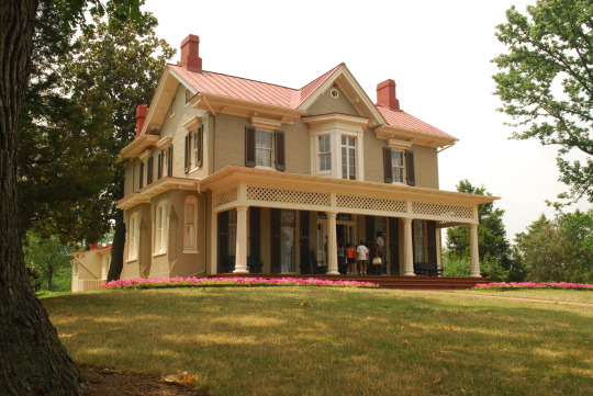
Landscapes of Literature: Frederick Douglass at Cedar Hill
At the Washington, D.C. home where Frederick Douglass lived from 1877 until his death in 1895, his relationships to language and to the landscape continue to come alive.
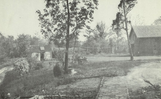
In the home known as Cedar Hill, bookcases line several walls of thelibraryaround the heavy wooden desk where Douglass read and wrote.
A walkway from the back of the house leads to a cozy windowless retreat, where Douglass kept a second desk filled with books and paper to write, read, and quietly contemplate. He called the structure the “Growlery,” a title used by characters of several Dickens novels to describe “a retreat for times of ill humour.” In the comfortable sanctuary of his Growlery, Douglass was able to study and write in peace. Once draped in vines and surrounded by fragrant shrubs, the structure is also thought to have fulfilled Douglass’s desire to work in a natural setting.
Photograph taken in the 1930s looking south from the historic house. Frederick Douglass’s Growlery (left) and barn (right) are visible, and a clothesline stretches between two trees over the backyard (NPS / Frederick Douglass National Historic Site).
Every year, the NPS hosts an oratorical contest in the auditorium at the Frederick Douglass National Historic Site for students in grades 1-12. The goal of the contest is for students to experience the same transformative power of language that Frederick Douglass experienced as a young man.
This year’s contest will be held on December 6-7, 2019, and students from across the country are invited to apply.
The house and surroundings of Cedar Hill, Frederick Douglass National Historic Site (NPS).
Additional image information can be found in NPGallery.
This month, we are exploring a few of the NPS cultural landscapes associated with writers and writing. Catch any you missed or add your own favorites with #literarylandscapes
National Park Service implements coronavirus mask mandate on lands, federal buildings
National Park Service implements coronavirus mask mandate on lands, federal buildings
Protective face masks are now a requirement for entry into a national park. The National Park Service announced its new mandate in a press release, which notes that the PPE requirement is in compliance with President Biden’s executive action that states masks must be worn on federal property, including parks and buildings. Mask wear is required for visitors, park employees, partners and…
As pandemic worsens, NPS faces growing load of infections
At the National Mall in Washington, at least four National Park Service employees have tested positive for COVID-19 in recent days as the pandemic hit its highest level yet in the nation’s capital. At Grand Canyon National Park in Arizona, officials said they’ve had 28 confirmed cases within the park. And in California, parks this week once again started closing campgrounds and other facilities…