#historic preservation


remains of the salt box, the former bunker hill residence which was relocated to heritage square. remnants of the structure are shown here the morning after a fire, 1969
Post link


Reims is considered the Art Deco capital of France because, after being heavily damaged in the First World War, a great deal of reconstruction took place in the 1920s and 30s. After the Art Nouveau style had run its course, the simpler lines of Art Deco became all the rage. Les Halles du Boulingrin is part of that architectural heritage.
The market hall, completed in 1929, is a listed historical monument with an impressively constructed ceiling. With no central supports on the inside, the parabolic arch spans a space more than 100 meters long and 38 meters wide. The tinted glass gives the interior a golden glow, and the side doors are highlighted with pale green polished cement. After falling into disrepair, the hall was renovated between 2008 and 2012. Markets are now held there twice a week.
Photos by Charles Reeza
Post link


In Pensacola working at Ft. Pickens today. The Mine Storage Building is having some mortar issues.

Pictures from the Cemetery Preservation Workshop that I just taught in Mooresville, NC. The weather was not the best but we had a great group of participants.
Post link


Pictures from the Cemetery Preservation Workshop that I just taught in Mooresville, NC. The weather was not the best but we had a great group of participants.
Post link


Pictures from the Cemetery Preservation Workshop that I just taught in Mooresville, NC. The weather was not the best but we had a great group of participants.
Post link


All said and done…150 volunteers scrubbed almost 5000 headstones and sprayed 7000 at Stones River National Cemetery.


My office for the day. At Mount Olivet Cemetery in Frederick Maryland teaching a workshop.


A Landscape of Change: Cape Hatteras Light Station
Twenty years ago, in the summer of 1999, the Cape Hatteras Light Station was moved 2,900 feet from the spot where it had stood since 1870.
As the natural process of shoreline erosion transformed this dynamic coastal environment, the tallest brick lighthouse in the United States now stood dangerously close to the ocean’s edge.
The remarkable undertaking including efforts to protect the structures, maintain the coastal setting of the original site, and preserve the original orientation to the shoreline and spatial arrangement of historic structures in the landscape.
Discover more about the transformation and preservation of this cultural landscape: Landscapes of Change: Cape Hatteras Lighthouse
- Photo album of the 1999 Cape Hatteras Light Station move
- Cape Hatteras Light Station Cultural Landscape Report
- Cape Hatteras Light Station Cultural Landscape Inventory
- Cape Hatteras National Seashore website
- More about cultural landscapes
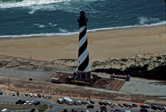
Driving the lighthouse along the beach to its new location on June 24, 1999 (NPS).
Post link

Parterre Planting
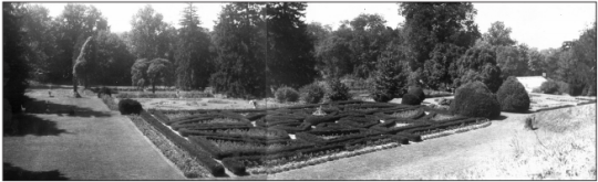
In 2010, the Falling Gardens at Hampton National Historic Site were rehabilitated to reflect their historic configuration. The six parterres that comprise the Falling Gardens were re-defined on the turf-carpeted terraces and replanted to represent circa-1867 planting schemes.
The garden rehabilitation helped evoke the grandeur of the historic landscape, which had fallen into disrepair by the mid-1900s with missing and overgrown vegetation.
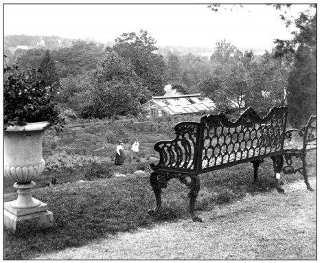
The Falling Gardens and Greenhouse #2 from the Great Terrace, looking southwest, 1872 (NPS/HAMP 3493, in Cultural Landscape Report).
The work didn’t end there, however.
Annuals are planted in the parterres each spring. This year, park staff, a summer work crew of 6 people, and volunteers planted 3,398 plants over a 2-week time period.
Want to see more of the 2019 parterre planting at Hampton National Historic Site?
(Recorded by and shared with permission of Tim Ervin, via Flickr.)

How do Cultural Landscape Reports inform landscape preservation?
Discover history, plant lists, before and after photos of the Falling Gardens, and more about Hampton National Historic Site cultural landscape :
- Cultural Landscape Report, Volume I (Site History, Existing Conditions, Analysis and Evaluation)
- Cultural Landscape Report, Volume II (Treatment and Record of Treatment)
The Falling Gardens and Greenhouse #2, c. 1935 (NPS/HAMP 19240, in Cultural Landscape Report).
Post link

Cultural Landscape Preservation
It’s already the end of May, which means that Preservation Month is coming to a close. Here are just a few ways to continue exploring cultural landscape preservation in the National Park Service:
You can also find access to the Integrated Resource Management Applications (IRMA) Portal there, an NPS-wide repository for documents, publications, and data sets related to natural and cultural resources of the National Park Service. The cultural landscape documents in this growing collection contain history, analysis, and treatment recommendations to support the management of cultural landscapes.
These videos highlight preservation projects in various park cultural landscapes, revealing how management documents (like Cultural Landscape Reports) guide preservation treatment that can impact the experience of historic places.
Keep celebrating preservation all year!
Post link
The Cultural Landscape at Harriet Tubman National Historical Park
Our nation has a rich legacy of cultural landscapes – from carriage roads to battlefields, designed gardens to vernacular homesteads, and industrial complexes to river valley settlements. The NPS Park Cultural Landscapes Program promotes the stewardship of significant landscapes through research, planning, maintenance, training, and education.
This video introduces the cultural landscape at Harriet Tubman National Historical Park and invites viewers to learn more. NPS staff from the park, descendants of Harriet Tubman, and other people associated with the area describe the features and significance of this unique landscape and actions that have been taken to preserve it.
This video, announced on March 10 in honor of Harriet Tubman Day, is the latest in a series of videos designed to facilitate the transfer of knowledge gained through cultural landscape research and communicate unique aspects of a particular landscape’s history and significance.
- Watch other videos in the series and find audio-described versions: Cultural Landscape Video Series from the NPS Olmsted Center for Landscape Preservation

Summer Internship Opportunity
Join the Olmsted Center for Landscape Preservation this summer as a Digital Media Resource Assistant, supported in partnership with the nonprofit American Conservation Experience.
As the Digital Media Resource Assistant, you will create ArcGIS StoryMaps and other digital media products for a national audience that convey a strong sense of place, sharing stories that capture the diverse perspectives shaping our cultural landscape heritage.
- Don’t miss the Designing the Parks blog to see what other interns with the Olmsted Center have been doing.
- Learn more about the Olmsted Center for Landscape Preservation.
[Image description: A group of Olmsted Center Associates, interns, gather on a rocky mountaintop in Acadia National Park, overlooking an expanse of trees and water below.]
Post link


Stewardship at Grand Portage National Monument
The Grand Portage Band of Lake Superior Chippewa and the National Park Service work together at Grand Portage National Monument to support, interpret, and protect the lifeways of the Ojibwe people, including the preservation of historic landscape features of the Grand Portage trail.
The Grand Portage was a vital part of both American Indian and fur trade transportation routes because of the area’s geology, topography, natural resources, and strategic location between the upper Great Lakes and the interior of western Canada. Grand Portage National Monument is in the homeland of the Grand Portage Ojibwe. The Band has long been involved in stewardship of the Monument, where tribe members play a critical role in management, landscape maintenance, and historic preservation.
- Discover more about this agreement, ethnobotanical restoration, the role of the Civilian Conservation Corps – Indian Division during the 1930s, and the youth contributions of the Grand Portage Conservation Crew: Stewardship at Grand Portage National Monument
- Learn more about Grand Portage National Monument
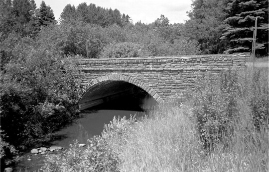
Historic bridge at Grand Portage National Monument before work, date unknown (NPS).
Post link


Army Corps of Engineers Road System Added to the National Register
Crater Lake National Park, Oregon
The Army Corps of Engineers Road System at Crater Lake National Park is among Oregon’s latest entries in the National Register of Historic Places.
The National Park Service accepted the nomination on August 12. NPS staff historian Stephen Mark took the lead in writing the nomination, which centered on a previously little-known effort by the Army Corps in highway engineering and construction that happened from 1910 to 1919 in the park.
The Army Corps of Engineers Road System, a precursor to the historic Rim Drive, is significant for its association with the earliest period of highway engineering in Oregon.
As Stephen Mark describes, “Unlike today’s roads, this system came into being with hand tools, horse power, and a couple of wood-burning steam shovels.”
The road system was the first federally funded and supervised highway project in Oregon and is the only road project in Oregon attributed to the Army Corps of Engineers.
The road system is the fourth historic district listed at Crater Lake National Park, with others at Rim Village, at Park Headquarters and along Rim Drive.
- Discover more about the nomination and the history of the road system: News Release: “National Register Listing for Army Corps of Engineers Road System”
- Visit the park website to plan your visit: Crater Lake National Park
- Find more from the National Register of Historic Places

A car on a road in front of impressive snow banks, almost completely obscuring a house, shows the winter conditions at Crater Lake, 1949.
(NPS/Harpers Ferry Center Archives)
Post link
The Legacy and Landscape of Harriet Tubman
To help honor Harriet Tubman’s first attempt at self-emancipation on September 17, 1849, the Olmsted Center for Landscape Preservation has created a short video highlighting Harriet Tubman, the remarkable landscape of Harriet Tubman Underground Railroad National Historical Park in Maryland, and some of the cultural landscape research they’ve conducted there to date.
“The Cultural Landscape at Harriet Tubman Underground Railroad National Historical Park” is the latest addition to the Olmsted Center’s cultural landscape video series. Each video highlights the unique aspects of a particular landscape’s history and significance, and together they help to communicate the process and outcomes of cultural landscape research.
- Find the full series at the link below, or at the Olmsted Center for Landscape Preservation website

Stewart’s Canal at dusk, at Harriet Tubman Underground Railroad National Historical Park (NPS).
Discover More
- Harriet Tubman Underground Railroad National Historical Park website
- Underground Railroad: More on this subject from the National Park Service
- Journeying toward Freedom and New Beginnings: A cultural landscape perspective of Harriet Tubman and the Jacob Jackson home site on the Eastern Store of Maryland
- Olmsted Center for Landscape Preservation video series (YouTube)
- More about NPS cultural landscapes


Field School at Prince William Forest Park
September has arrived. It’s the time of year when many people return to classrooms and get ready for the school year ahead. It’s also a great time to reflect on ongoing educational partnerships and the year-round learning that takes place out of the classroom.
Beginning in summer of 2018, students from the University of Mary Washington participated in a field school to document two cultural landscapes at Prince William Forest Park, Cabin Camp 2 and Cabin Camp 4. The Cabin Camps at Prince William Forest Park were developed in the 1930s as part of the Recreation Demonstration Area program.

The typical four-person sleeping cabin in Cabin Camp 2 at Prince William Forest Park (NPS).
Over several weeks, the students documented existing conditions of landscape features. In addition to the hands-on experience, their documentation will be used to complete Cultural Landscape Inventory (CLI) reports, which are an important tool for the continued management of park cultural landscapes.
The outcomes and lessons learned by the National Park Service, UMW faculty, and students helped shape the 2019 field season and will serve as a model for future iterations of the field school.
- Learn more about this educational partnership to document these cultural landscapes and the history of the cabin camps in our latest article: Field School at Prince William Forest Park
- More about Prince William Forest Park
- Historic Preservation at University of Mary Washington
- What are cultural landscapes?
(Thanks to colleagues in the National Capital area for assistance with this article!)
Post link

First day of fall in witch city

Tudor architecture refers to the particular type of architecture, in a time period between 1485 to 1558. It occurs with the reign of the Tudor monarchs and becomes the final development of Medieval architecture in England and Wales. As many other styles, Tudor architecture had a number of distinctive features that separated it from Medieval period and later designs. An excessive usage of half-timber work and masonry, wide chimneys, inglenook fireplaces, four-centred arches, jettied top floors, heavy doors, large windows, landscaping and little gardens around the house, etc.
Benthall Hall in the town of Broseley, Shropshire, England.
⚜ Tudor month on @mynocturnality


Paul Rudolph’s Burroughs Wellcome under demolition. Photos December 2020 Bauzeitgeist. I wrote about the loss of the building here on Substack.
Post link