Roughly 88% of the world’s population lives in the northern hemisphere, and about half the world’s population lives north of 27°N. Taking the northern and southern hemispheres together, on average the world’s population lives 24 degrees from the equator.
These colourful images show the heights and density of buildings in different cities around England. Taken from a new interactive map produced by Emu Analytics, they are created using Environment Agency LiDAR data, an airborne mapping technique. Data was only available for England
The Commissioners Plan of the City of New York in 1807
The 1807 version of the Commissioners’ grid plan for Manhattan was adopted in 1811.
TheCommissioners’ Plan of 1811 was the original design for the streets of ManhattanaboveHouston Street, which put in place the rectangular grid plan of streets and lots that has defined Manhattan to this day. It has been called “the single most important document in New York City’s development,”[1] and the plan has been described as encompassing the “republican predilection for control and balance … [and] distrust of nature.”[2] It was described by the Commission that created it as combining “beauty, order and convenience.”[2]
The plan originated when the Common Council of New York City, seeking to provide for the orderly development and sale of the land of Manhattanbetween14th StreetandWashington Heights, but unable to do so itself for reasons of local politics and objections from property owners, asked the New York State Legislature to step in. The legislature appointed a commission with sweeping powers in 1807, and their plan was present in 1811.
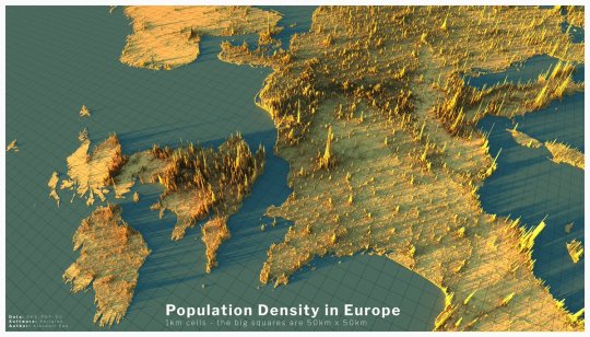
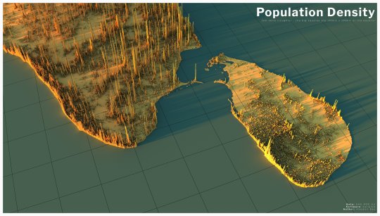
Global population density graphic made by Alasdair Rae founder ofAutomatic Knowledge. It shows world population density in 3d (approximately 7.8 billion people as of 2020), no land is shown on the map, only the locations where people actually live. The height of the spikes relates to the number of people living in an area, roughly 2Km x 2Km. Data/map prints are available here.
This is a short drone tour of San Francisco with the shelter-in-place order in effect — it looks abandoned. Fisherman’s Wharf, downtown, Market Street, the Haight — I think I saw like 8 people total during the whole video. Heartening to see that people are taking shelter-in-place seriously.
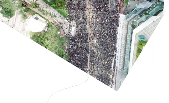
“An estimated 1.7 million people in Hong Kong—A QUARTER OF THE POPULATION—defied police orders to stage a peaceful march after a rally in a downtown park, after two months of increasingly violent clashes that have prompted severe warnings from Beijing and failed to win concessions from the city’s government.
Huge crowds filled Victoria Park on Sunday afternoon and spilled on to nearby streets, forcing police to block traffic in the area. Torrential rain came down an hour into the rally, turning the park into a sea of umbrellas. At the same time, protesters walked towards Central, the heart of Hong Kong’s business district, and surrounded government headquarters.”
Visual clutter remains a challenge in cartography, especially for web maps depicting voluminous, unfiltered collections of point type data. This issue is particularly prevalent in datasets generated in cities due to urban density. Professor Andrew Vande Moere and myself developed BinSq(abbreviated Bin2), a novel gridded dot density mapping technique to overcome this challenge. We demonstrate this technique on a large dataset of language referenced, geotagged tweets to reveal language communities in Brussels. The figure above compares our technique to the [a] standard dot map and six related solutions namely: [b] jittering, [c] refinement, [d] distortion with pixel map as well as [e] aggregation with categorical binning, [f] splatter plot and [g] dot density map. Our output is depicted in [h]. An implementation of BinSq in Java is avaliable on GitHub. Read our paper for a complete description of the technique.
Hundreds of thousands of people poured into the streets of Hong Kong on Sunday, June 16, and marched almost two miles (three kilometers), protesting a proposed extradition bill and calling for the city’s leader to step down.
It was the largest of three major protests against the bill that were held over eight days. More demonstrations are scheduled for Wednesday, ahead of the Group of 20 summit meeting in Osaka, Japan. The composite images below help show the enormous scale of the June 16 demonstrations.
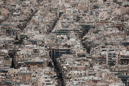
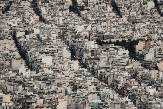
Soil by Greek-Japanese photographer Margarita Yoko Nikitaki is a photographic project shot in Athens, Greece’s capital city. Margarita reached the top of Athens’ hills to observe the city as she looked for ideas on how to visualize the effects of human intervention.
“In the images we see a series of condensed, homogeneous and grey stacks of constructions, streets and city blocks that seem to be colliding with each other into a mass devoid of a horizon,” Margarita explains. “The pictures show the extensive densification of the Athenian cityscape that has been taking place over the last 100 years. What the images don’t show is that Athens is actually surrounded by four large mountains and several hills, but at ground level the bare soil has been replaced by cement, and the horizon has been replaced by the urban skyline.”
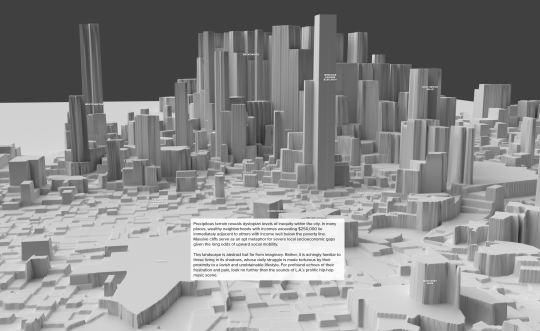
The Topography of Wealth in L.A. Visualizing Income Inequality as Terrain ByNick Underwood
Los Angeles has 58 billionaires and 58,000 homeless people. In a city where destitution coexists with opulence, vast gaps in opportunity exist between neighborhoods. Let’s use physical terrain as a metaphor to visualize income inequality across LA.
A new strategy for packing hard spheres of different sizes could lead to novel ways of creating strong, lightweight materials.
[…]
To create structures that are light and strong, researchers leverage the interplay between internal compression and tension, removing unnecessary material that does not contribute to this balance of forces. Because packed assemblages of hard spheres lack internal tension, the conventional wisdom is that reducing the density of such structures eventually leads to instabilities, establishing limits on how strong and lightweight they can be. Now, Robert Dennis and Eric Corwin at the University of Oregon have found a way to pack hard spheres at vanishingly small densities such that their structures are as light as desired while remaining mechanically stable [1].


, 2006 S")


 Oak Street Beach, 1930 2) VJ Day, State Street, August 14, 1945 3)")
 Oak Street Beach, 1930 2) VJ Day, State Street, August 14, 1945 3)")
 Oak Street Beach, 1930 2) VJ Day, State Street, August 14, 1945 3)")


