Detroit has been through decades of social and financial problems ever since the city slowly slumped into oblivion and collapsing on itself until bankruptcy. The auto industry fueled the city’s growth for many years starting at the beginning of the 20th century with the advent of the automobile.
Fast-forward to the 21st century and everything is gone from the city once thrived with the biggest industry of the West. But it wasn’t enough for Detroit as it gamble its entire economy on cars rather than diversifying the industry investing in different fields. By the time politicians realized that it was too late.
We can trace back how the city developed into something fit only for those having the ability to afford cars, while the rest of those who relied on walking were left out of the equation for good. Today Detroit still lags behind in having an effecting public transportation system to make a significant impact, but it’s very hard when the entire city was developed inside the car-culture.
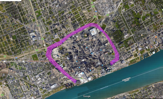
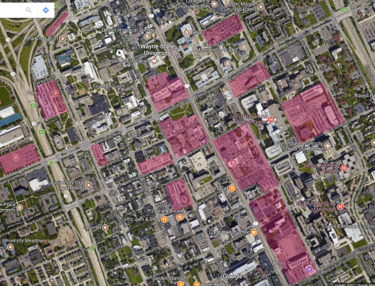
Three freeways isolate downtown from the rest transforming it in a citadel.
One of the main issues that affected the urban development and prevented the city from adopting a better road system, was the the layout of the freeway system that chokes downtown Detroit. The John C. Lodge, Fisher, and Chrysler freeways surround the urban center isolating it from the rest of the city.
Artificial barriers in the form of roads, ramps, collectors, are responsible for creating specific condition among neighbors, mostly negatively impacting hundreds of blocks at the time. Developers find this method very useful to separate high and low values housing so it won’t affect the pricing market, thus ensuring specific parts of town remain within a specific yield of profits.
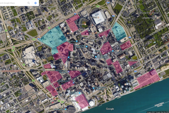
Another important issue is the large presence of parking lots surface downtown. Highlighted in red the volumes dedicated to car parking are spread out comprising a large portion of the city core. Whenever cars have a place to be stored they will create incentive to use them everywhere as an extension of people’s lives that cannot be excluded.
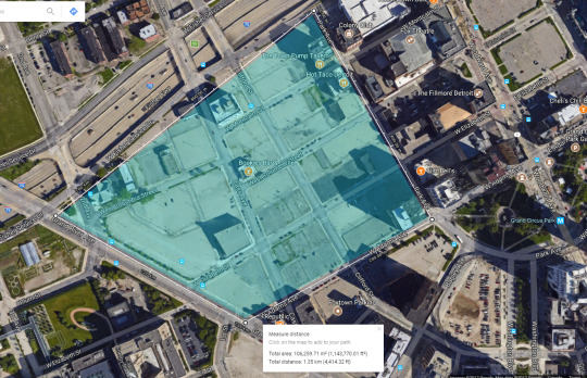
The two portions in blue represent large areas of vacant lots that once hosted buildings. Today they leave tremendous gaps between blocks that reminds of Berlin in 1946 after the rubble removal. Focusing on the site located on the top-left corner we can comprehend how much Detroit has been neglected.
The highlighted area has an approximate dimension of 176,900 square meters of vacancy (plus/minus the presence of some buildings).
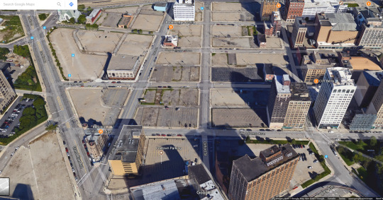
A close up of the area shows how depressing the area appears. Temporarily parking lots are placed where once buildings stood as there is no certainty of the urban plan for this area.
Uptown faces the same issues of large presence of parking areas that make up for a large potion of the space. The gargantuan suburb conveys tens of thousands of drivers every day requiring areas to leave their vehicles somewhere. Although commercial and public volumes required park spots for obvious reasons, they still represent a small percentage compare do the rest.
The red area represents the high-density portion of Detroit while the yellow one is low-density with suburban-type zones. This has been impacting the city for decades: everything revolves around vehicle ownership and those who don’t cannot rely on the weak public transport system or downtown residency.
Crime and high rents have pushed people away from the high-density areas towards the suburbs. Downtown is a corporate fortress that is ‘protected’ by a ring of freeways which doesn’t allow for a smooth transition towards the fringes.
The sprawl of Detroit -like many American metropolis- has impacted the life style of many citizens who are subjugated to the condition their neighbors dwell. In the last 20 years the city has suffered from crime sprees, major city corruption, financial collapse.
To build and to maintain such enormous suburbs required billions of dollars that cannot be made back in tax revenues: low-density neighbors don’t yield enough property taxes. The city was lost with a 20 billion dollar budget gap in 2013 after declaring bankruptcy.
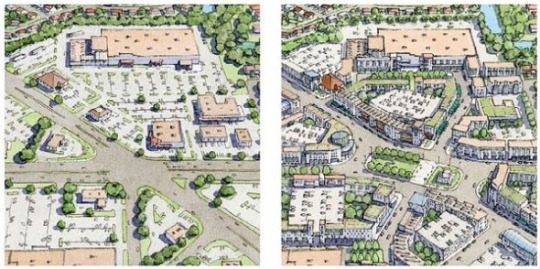
The only way for Detroit to swamp itself out is to drastically rethink its urban design by reshaping vacant lots and abandoned neighbors. Building hi-density zone with enough green and public surface will create a major investment for the future.
At the same time public transportation must be made bigger than it is today, so streetcars and buses will have to increase in fleet size and stop network to provide access to everybody from the city fringes to downtown.
Retrofitting neighbors has the best ability to render any city a place worth caring for. Once dead malls and flat surfaces are reborn building gracious communities and promoting pedestrian activity, then everything can become precious again . Areas that are well lit and offer rich patterns in their design will always engage the eye placing more importance in its care and existence.
Detroit can surely use what New Urbanism has done to other cities by reclaiming unused volumes and structures to increase their values by tailoring places around people first and cars second. Redeveloping city blocks opens for new opportunities of business and residential units for mixed using, departing from the old concept of leaving the housing pod with the car just to make small purchases.
How can we make spaces more equitable? How can resources, specifically land, be better distributed? How is access restricted and how does it affect communities? These are the questions asked by Bimkom: Planners for Planning Rights, who strive “to enhance the link between civil rights, social justice, and the planning process in Israel.” They work in underprivileged communities against “spatial discrimination” with Palestinians in the Galilee and Area C, Bedouin groups, and those in low-income urban spaces.
While planning reinvents space and order, it also restricts them. This is seen all too clearly in the expansion of national parks in Jerusalem. All green spaces are considered property of the government (like 90% of land in Israel) and liable for “confiscation” and not “expropriation,” for which landowners receive compensation. The Israel Nature and Parks Authority (INPA) is taking measures to extend parks right up to the homes of Palestinian homes and schools to limit development of Palestinian neighborhoods and ultimately ensure a Jewish dominance and demographic majority. It doesn’t hurt that a number of the top officials in the INPA are high-profile settlers, including its general manager, Saul Goldstein, and Evyatar Cohen, in charge of the Jerusalem branch of the INPA and a former employee of Elad, a settler organization that runs the City of David National Park, located right in the middle of the Palestinian village of Silwan in East Jerusalem.
The other National Park making the headlines recently is the Mount Scopus National Park, also in East Jerusalem to be established on the lands of the Palestinian villages of Issawiya and A-Tur. With permits still pending, construction has already begun. Establishing this park creates continuity of Israeli territory from the Old City to the settlement of Maale Adumim, located in E1, an area where the US government opposes Israeli building since it will permanently seal off Palestinian access to East Jerusalem—and with it, the possibility of a two-state solution.
Complaints by leftist organizations working for planning justice like Bimkom, Emek Shaveh, and Ir Amim come at a crucial time when a proposed law to privatize public parks is making its way through the Knesset. If the bill passes, Elad will retain control of the historic site situated in the Arab village of Silwan. But it might also have unforeseen consequences. Who knows how far the appropriation and commercialization of historic and national landmarks can go? When it’s no longer just Palestinians being disenfranchised by these policies, will Israelis finally start paying attention?
The color of the past: the view from an Angels Flight car, looking back at the crest of Bunker Hill, 1950’s. From a remarkable series of color photographs of Bunker Hill taken by the actor George Mann before “redevelopment” claimed the many 19th and early 20th century residential structures that made up the heart of old downtown Los Angeles.
A reconstruction of the Towers of Bologna in the 12th Century. One hypothesis for the prevalence of the structures is their utilisation by wealthy families for offensive/defensive purposes.
One cannot help but to conjure images of Corbusier’s ‘La Ville Radieuse’ or the Futurist cityscapes of Antonio Sant’Elia
Plus catalogues the last 8 years, each of the works realized with WATERSHED+ and the artists and teams involved. Alongside this documentation we invited six prominent arts voices – a combination of artists, curators, writers and editors - to explore a topic and to complement the narrative of the program, projects, and process from their experiences. These art subject matter experts bring knowledge about contemporary art, urban and cultural development, and insights into creative processes. Plus also outlines the less tangible outcomes and provides recommendations for the future of the program.
“We have always struggled with trying to define WATERSHED+ – it’s a plan, a program, an artwork. It is processed-based work, with temporary and permanent work. It is performance and collaborative. It is artist-lead, municipal, internally and externally focused; it is engaging, informing, educational. It is engineering. It is art. It is serious, critical, joyous, challenging, and celebratory. […]
It’s all of these things, it’s blurry. ”
“[…] This is the story of the first phase of WATERSHED+. It catalogues projects, who was involved and the outcomes. It contains people’s opinions and experiences from many points of view: engineers, artists, managers, and critics – many of whom helped shape the program it has become. ”
FromPlus, Introduction
WATERSHED+ is a City of Calgary public art project
Essays by: Tatiana Mellema, Hesse McGraw, Diana Sherlock, Susan Szenasy, Shauna Thompson and Janet Zweig
Interviews of staffs and artists by amery Calvelli
Plan for a Greater Baghdad, 1957-1959, Baghdad, Iraq
from the exhibition City of mirages: Bagdad 1952-1982, helded in New York’s Center for Architecture in 2008 organized by Collegi d´Arquitectes de Catalunya in Barcelona and curated by academic from UPC-Barcelona, Pedro Azara Nicolás.
Another collaboration with Becky Hawkins! (frenchtoastcomix) This one was written by me, and drawn by Becky. If you enjoy these cartoons, please reblog or support them on my Patreon . A $1 pledge really helps!
The panel shows backed-up traffic on an overpass in the foreground. In the background, we can see more backed-up highways, and behind that the buildings of a small city, including a white building with a big dome on top and a US flag - i.e., a government building. Two word balloons come from that building. The balloons belong to characters I will call MAYOR and NERD.
MAYOR: The city just spent half a billion widening roads. But we still have traffic congestion!
NERD: Well, Mr. Mayor, studies show that adding lanes doesn’t fix traffic.
PANEL 2
Inside the mayor’s office. There is a big curtained window and a fancy executive desk with a big leather chair. In front of the desk is the Mayor - a man in a suit with gray hair - and a woman who is a nerd, by which I mean she’s wearing glasses, has her hair in a bun, and is carrying a stack of three-ring binders.
The Mayor is making a “stop talking” gesture, holding up a hand flat in front of the nerd’s face. The mayor looks angry, and his eyes are bloodshot.
NERD: People’s capacity to drive is greater than our capacity to build roads, so-
MAYOR: Blah blah blah! We’ve got to do something!
PANEL 3
The mayor, now looking happy, makes a big sweeping gesture with his hand, causing the surprised nerd to drop her binders.
NERD: Um…
MAYOR: I’ve got it!
PANEL 4
The mayor and the nerd are now on stage, the mayor behind the podium and the nerd to one side and behind him. There is a cheering crowd watching the mayor speak.
The Mayor is waving a hand grandly as he speaks. The nerd is face-palming.
MAYOR: Good news, citizens! We’re widening the roads again!


 This one was written")