The park has served as a filming location for numerous films. The Endor scenes for Star Wars Episode VI: Return of the Jedi were filmed in the Tall Trees Redwood Grove in the northern part of Humboldt County. Scenes for The Lost World: Jurassic Park as well as the movie Outbreak were filmed at the nearby Prairie Creek Redwoods State Park and at Patrick’s Point State Park.[44]
Redwoods’ also used as Jurassic Forests of Colorado in Walking with Dinosaurs in “Time of the Titans” and 2007 IMAX film Dinosaurs Alive!, where they used as Triassic Forests of New Mexico, which was based on Petrified wood in Petrified Forest National Park in Arizona. The Muir Woods National Monument near San Francisco is featured in the 2011 Planet of the Apesprequel,Rise of the Planet of the Apes.
The Commissioners Plan of the City of New York in 1807
The 1807 version of the Commissioners’ grid plan for Manhattan was adopted in 1811.
TheCommissioners’ Plan of 1811 was the original design for the streets of ManhattanaboveHouston Street, which put in place the rectangular grid plan of streets and lots that has defined Manhattan to this day. It has been called “the single most important document in New York City’s development,”[1] and the plan has been described as encompassing the “republican predilection for control and balance … [and] distrust of nature.”[2] It was described by the Commission that created it as combining “beauty, order and convenience.”[2]
The plan originated when the Common Council of New York City, seeking to provide for the orderly development and sale of the land of Manhattanbetween14th StreetandWashington Heights, but unable to do so itself for reasons of local politics and objections from property owners, asked the New York State Legislature to step in. The legislature appointed a commission with sweeping powers in 1807, and their plan was present in 1811.
It started with a tweet from Lara Trump. On September 28, 2019, the House of Representatives was preparing for impeachment hearings against Donald Trump. And she posted the electoral map from 2016—a familiar sea of red that implies America itself is Republican. Over the top of it, the caption read, “Try to impeach this.”
The Belgian designer Karim Douïeb—who runs his own data visualization company, called Jetpack—came across the post. It bugged him because, like so many electoral maps, it framed thousands of miles of empty land as voting for Trump instead of representing the few people actually living in it.
“I told myself, this is completely wrong in terms of data visualization,” Douïeb recalls. “I’m not so into politics or anything, but I had to correct this visual mistake.”So after work one night, after putting the kids to bed, he spent two hours on a retort.
“Challenge accepted,” he wrote on October 8, 2019, as he posted the perfect correction: A GIF that started as Laura Trump’s 2016 electoral map but then transitioned to a more accurate representation, which depicted the actual count of red and blue votes in counties across the nation as simple circles, their size proportional to the number of votes. And finally, Americans had a portrait of our country’s voting habits that was accurate: Not the normal sea of red, but a polka-dotted country, where blue voters are ever so much more prominent than red ones.
While all public spaces around the world are trying to innovate and implement safety measures to open during the coronavirus pandemic, Domino Park has introduced a series of painted social distancing circles. This strategical urban design intervention ensures that people are “following proper social distancing procedures recommended by the CDC and government”.
Designed by landscape architecture firm James Corner Field Operations and privately-funded by Brooklyn-based developer Two Trees Management, Domino Park has been accessible to the public ever since the summer of 2018. In order to encourage safe park visitation practices, during this pandemic, the park has recently implemented social circles in its open public space.
Elaborated by Domino Park’s staff members, the project generates a series of chalk painted circles on the astroturf Flex Field. Introduced on May 15th, the intervention puts in place 30 circles: each circle is 8 feet in diameter and set 6 feet apart. Immediately famous with the visitors, the social distancing rings “took a few $.99 cans of white chalk paint from the local paint store, 2 people, and 4 hours”.
Along with this strategic tactical urbanism, Domino Park has continued to display various types of signage about social distancing and wearing masks. Moreover, the quarter-mile waterfront park highlights safety rules constantly on his social media pages. During times of peak visitation, Domino Park has even closed River Street.
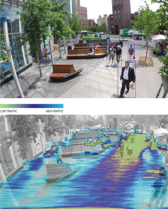
This research project reconsiders writer William H. Whyte’s Street Life Project and seminal study The Social Life of Small Urban Spaces (1980). It sought to understand how the types of new public spaces have changed some 40 years after he published his book and companion film, what has changed in how people use public realm spaces, and what makes well used spaces.
The project first looked at 10 plazas in Manhattan by 10 different designers, constructed or renovated in the last 15 years. The sites range from the type of bonus plazas Whyte was observing, to infrastructural leftovers, alleys, transit plazas, private campus spaces, and tactical urbanist interventions. The team used new analytical tools such as a machine learning algorithm on video footage to develop heat maps describing dwell time, frequent and infrequent usage, and preliminary pedestrian counts.
The team also used some of the same techniques Whyte did—behavioral observations, site measurements, and hand tabulation. The goal was to identify common behavior patterns, collective activity, programming, physical elements, and understand context across the sites in order to inform future public realm design. Findings and methods were published in a booklet called Field Guide to Life in Urban Plazas. Currently, researchers are experimenting with an extension of the New York study on other international sites using infrared data that allows evening site usage to be captured, as well as a higher level of anonymization.
RESEARCH TEAM Emily Schlickman and Anya Domlesky, XL research and innovation Lab at SWA, Tom Balsley, Chella Strong, Jen Saura, and Hallie Morrison, SWA/Balsley, Anonymous, Data Scientist
This is a short drone tour of San Francisco with the shelter-in-place order in effect — it looks abandoned. Fisherman’s Wharf, downtown, Market Street, the Haight — I think I saw like 8 people total during the whole video. Heartening to see that people are taking shelter-in-place seriously.
Butterflies near salted roads grow larger eyes and muscles
by Sandhya Sekar
You might be able to cut the salt in your diet, but the wildlife near salted roads doesn’t have a choice. It’s not all bad, though – salt may boost the brawn of butterflies.
When roads are salted in icy conditions, some of the run-off is taken up by plants. To find out if raised sodium levels in roadside plants might affect animals that feed on them, Emilie Snell-Rood at the University of Minnesota, St Paul, and her colleagues assessed local monarch butterflies, which feed on milkweed plants.
The team found that milkweed plants at the roadside contained 16 times as much sodium as those 100 metres away from the road. The butterflies reared on these plants had, on average, 6 times as much sodium in their bodies as those reared on prairie plants, and were less likely to survive beyond the caterpillar stage. But sodium is essential for the development of nerve and muscle tissue in animals, and those butterflies that did survive on high-sodium leaves also experienced a growth spurt: males had bigger flight muscles and females had significantly larger eyes…


")
