Had the pleasure of working on these absolute weirdos for PBS Eons’s latest episode, the alvarezsaurids BannykusandAlbertonykus. Check out this week’s video on the evolution of these dinosaurian anteaters!
Just over a year ago I wrote about how far ViziCities has come from its roots as a hobby project back in early 2013, all the way to becoming a fully fledged company at the end of 2014. It’s been an exciting time for ViziCities since then. In the past year alone I’ve had the pleasure to work with large companies spanning a variety of industries, using ViziCities to improve the way they interact with and understand their data. What this has made absolutely clear is that ViziCities is the perfect tool for companies and city authorities to quickly and intuitively understand their geospatial data and make relevant decisions far quicker than they were able to previously.
Map-based information is one of our biggest and richest assets at Uber. The billions of GPS points handled by our platform every day in real-time pose atypical challenges for real-time mapping visualizations and in-browser, data-dense visualizations. […]
Our tech stack for these applications consists on a few libraries that we developed and open sourced.react-map-gl provides a React-friendly layer on top of MapboxGL, a library from Mapbox that we use extensively at Uber. deck.gl provides an interface for creating WebGL-powered layers that can be put on top of a map or used standalone for creating abstract data visualizations. […]
We recently created a data visualization that explores how uberPOOL can have an impact in making cities’ transportation much more efficient. Behind Travis Kalanick in his TED Talk, you’ll see the data visualization we crafted to show traffic per street segment with and without uberPOOL, demonstrating POOL’s ability to make cities smarter by reducing traffic.
The interesting conclusion is that after about five minutes, the longer you wait, the longer you will have to wait. If you waited for 15 min, the medianadditional waiting time is another 8 minutes. But 8 minutes later if the train still hasn’t come, the median additional waiting time is now another 12 minutes.
So when should you give up waiting? One way to think about it is how much time you think it’s worth waiting. The time you already waited is “sunk cost” so it doesn’t really matter. What matters is how much additional time you are willing to wait. Let’s assume you want to optimize for a wait time that’s less than 30 min in 90% of the cases. Then the max time you should wait is about 11 minutes until giving up (this is at the point where the yellow line cuts the 30 min mark).
Re-imagining spaces in NYC as places for free speech, assembly and creative expression. A design competition inspired by the first amendment.
Free speech is essential for a vibrant culture and a democratic society, yet spaces for public expression seem harder and harder to find in the places where we live, work and play.
What does a space for free speech look and feel and sound like? Can they be designed? Are there places in New York City where we can design them?
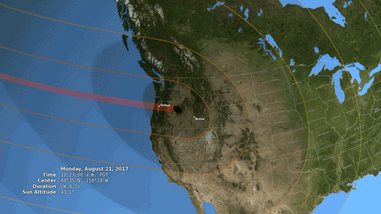
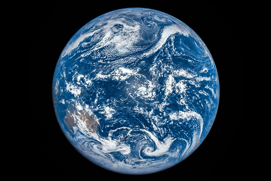
Just two months from now, the moon will completely block the sun’s face, treating part of the US to a total solar eclipse.
Everyone in North America will have the chance to see an eclipse of some kind if skies are clear. Anyone within a 70-mile-wide swath of land — called the path of totality — that stretches from Oregon to South Carolina will have the chance to see a total eclipse.
Throughout the rest of the continent, including all 50 United States — and even in parts of South America, Africa, Europe, and Asia — the moon will partially obscure the sun, creating a partial eclipse.
Photo credit: NASA/Cruikshank
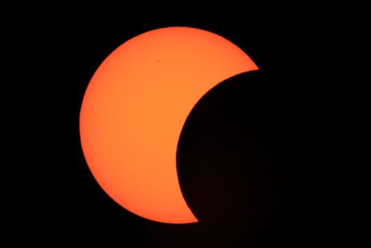
An eclipse is one of nature’s most awesome sights, but safety comes first! When any part of the sun’s surface is exposed, use proper eclipse glasses (not sunglasses) or an indirect viewing method, like a pinhole projector. In the path of totality, it’s safe to look directly at the eclipse ONLY during the brief moments of totality.
During a solar eclipse, the moon passes between the sun and Earth, casting a shadow down on Earth’s surface. We’ve been studying the moon with NASA’s Lunar Reconnaissance Orbiter, and its precise mapping helped NASA build the most accurate eclipse map to date.
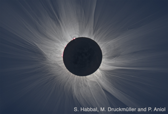
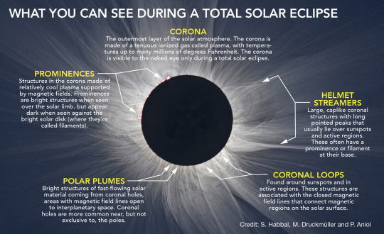
During a total solar eclipse, the moon blocks out the sun’s bright face, revealing the otherwise hidden solar atmosphere, called the corona. The corona is one of the sun’s most interesting regions — key to understanding the root of space weather events that shape Earth’s space environment, and mysteries such as why the sun’s atmosphere is so much hotter than its surface far below.
This is the first time in nearly 100 years that a solar eclipse has crossed the United States from coast to coast. We’re taking advantage of this long eclipse path by collecting data that’s not usually accessible — including studying the solar corona, testing new corona-observing instruments, and tracking how our planet’s atmosphere, plants, and animals respond to the sudden loss of light and heat from the sun.
We’ll be studying the eclipse from the ground, from airplanes, with research balloons, and of course, from space.
Three of our sun-watchers — the Solar Dynamics Observatory,IRIS, and Hinode, a joint mission led by JAXA — will see a partial eclipse from space. Several of our Earth-observing satellites will use the eclipse to study Earth under uncommon conditions. For example, both TerraandDSCOVR, a joint mission led by NOAA, will capture images of the moon’s shadow from space. Our Lunar Reconnaissance Orbiter will also turn its instruments to face Earth and attempt to track the moon’s shadow as it moves across the planet.
There’s just two months to go until August 21, so make your plans now for the big day! No matter where you are, you can follow the eclipse as it crosses the country with live footage from NASA TV.
Learn more about the upcoming total solar eclipse — including where, when, and how to safely experience it — at eclipse2017.nasa.gov and follow along on Twitter @NASASun.
So I’ve decided to document all of my traveling and language learning on my website and on my brand new Facebook page!
Please check it out and pass it around if you find it interesting; I’ve been working really hard on writing some new posts about all of the countries I visited last summer! <3
The Alamo is a sacred indigenous (Tap Pilam Coahuiltecan) burial ground. It’s not just a pretty building in the middle of a city; it is a sacred site which the Texas Historical Commission has repeatedly disturbed. Even during this pandemic, the THC is trying to disturb four indigenous remains from the burial site. Tap Pilam people have been calling for them to stop, their entire tribal website is plastered with the issue, yet the THC doesn’t set up even a sign at the Alamo that acknowledges the sacred nature of the area or the issues of Tap Pilam people today.
Instead of saying “remember the Alamo” please say “remember the burial grounds.” This is a sacred site for Tap Pilam people.
In 1986, Expo 86 was held in Vancouver, British Columbia. Wanting to be the main attraction, McDonalds built a 57-metre-long barge which was named “The McBarge.” It had intended to showcase future technology and architecture. However, it wasn’t as popular as they had anticipated and was left abandoned to decay.
Built in 1955, Holy Land USA, located in Waterbury, Connecticut, is an 18-acre them park inspired by Bethlehem and Jerusalem during the Biblical era. It was closed in 1984 by the creator, John Baptist Greco, as he had planned to improve and expand the park. Sadly, Greco passed away in 1986 and Holy Land USA was left abandoned.
Prior to 1861, the state of Louisiana had no official flag. In January 1861, after seceding from the United States but before the formation of the Confederate States of America, Louisiana unofficially used a flag based on the flag of France.
In February 1861, Louisiana officially adopted a flag with a single yellow star in a red canton, reminding of the colours of the Spanish flag, and with thirteen red, white and blue stripes, the colours of the French flag.
This was used through the end of the American Civil War, though the Pelican flag and Flag of January 1861 remained in use unofficially. In 1912 this flag was eventually replaced by a new version of the Pelican flag.
Lethbridge is a city in the province of Alberta, Canada. After the US Army stopped alcohol trading with the Blackfeet Nation in Montana in 1869, traders John J. Healy and Alfred B. Hamilton started a whiskey trading post at Fort Hamilton, near the future site of Lethbridge.
Artist Alex Johnston used a photograph of the flag that flew at Fort Whoop-Up (the nickname of Fort Hamilton) in the late 19th century as the basis for his rendition of the modern flag. He also used some contemporary written descriptions.
The Fenian Brotherhood was an Irish republican-Irish American organisation founded in the United States in 1858 by John O’Mahony and Michael Doheny. Members were commonly known as “Fenians”. They issued a bombastic proclamation in America announcing an imminent general rising in Ireland.
The flag is based on the American ‘Stars and Stripes’ It has four bars representing the provinces of Ireland and 32 stars representing the counties.
The Fenian Rising proved to be a “doomed rebellion,” poorly organised and with minimal public support. The Fenian Brotherhood itself, however, continued to exist until voting to disband in 1880.


, 2006 S")


 bur")