#geografía
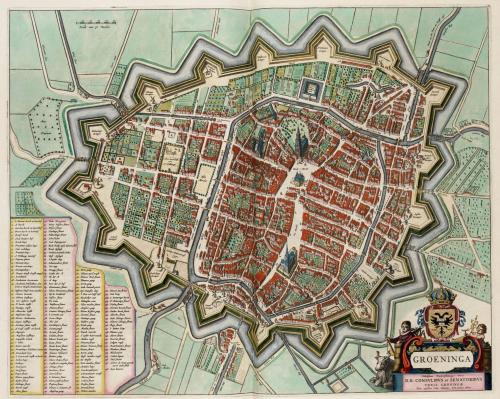
GRONINGEN, THE NETHERLANDS (1649) / GRONINGEN, PAÍSES BAJOS (1649)
Source:Reddit: Crazyhankie
More maps on http://geomapping.tumblr.com/
Post link
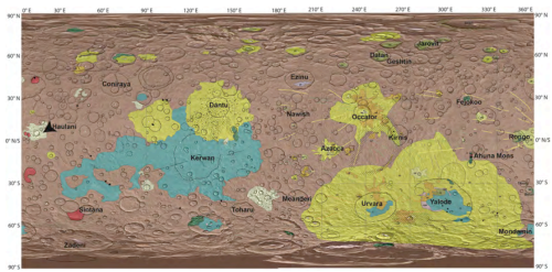
GEOLOGIC MAP OF CERES (Dwarf planet) / MAPA GEOLÓGICO DE CERES (Planeta Enano)
Source:Eureca: El Blog de Daniel Marín
More maps on http://geomapping.tumblr.com/
Post link
COMIC MAP OF EUROPE (1856) / MAPA CÓMICO DE EUROPA (1856)
Crimea War / Guerra de Crimea
Name
:
Komische Karte des Kriegsschauplatzes
Source: Bernhard Salomon Berendsohn
More maps on http://geomapping.tumblr.com/
Post link
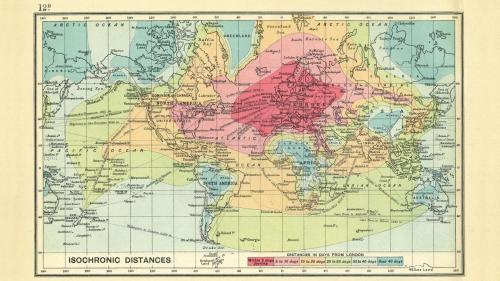
ISOCRONIC DISTANCES (LONDON - 1914) / DISTANCIAS ISOCRÓNICAS (DESDE LONDRES - 1914)
Time travel from London in 1914 / Tiempo de viaje desde Londres en 1914
Source:Intelligent Life Magazine
More maps on http://geomapping.tumblr.com/
Post link
FIRST GENETIC MAP OF THE UNITED KINGDOM / PRIMER MAPA GENÉTICO DEL REINO UNIDO
Source:BBC
More maps on http://geomapping.tumblr.com/
Post link
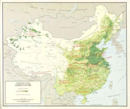
Agricultural map of Communist China, 1967 #map#agriculture#china
via [Pinterest pinned to the Nordpil Interesting Maps Pinterest Board]
Post link
THE WORLD WIDE METRO MAP PROJECT / MAPA DE METRO MUNDIAL (EN PROYECTO)
Source:ArtCodeData
More maps on http://geomapping.tumblr.com/
PLACES IN EUROPE WHERE YOU CANNOT LIVE / LUGARES EN EUROPA DONDE NO ES POSIBLE VIVIR
Source:LBV
More maps on http://geomapping.tumblr.com/
Post link
British Isles in 2100 by JaySimons #map#uk#ireland#eire#climate#climatechange
via [Pinterest pinned to the Nordpil Interesting Maps Pinterest Board]
ISLAS BRITÁNICAS EN EL AÑO 2100
Source:Jay Simmons
More maps on http://geomapping.tumblr.com/
Post link
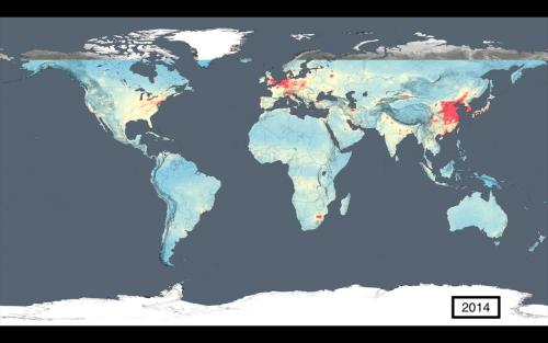
EVOLUTION OF AIR POLLUTION / EVOLUCIÓN DE LA CONTAMINACIÓN DEL AIRE
Source:NASA
More maps on http://geomapping.tumblr.com/
Post link
Ethnic groups of the Caucasus, 1887 #map#caucasus
via [Pinterest pinned to the Nordpil Interesting Maps Pinterest Board]
GRUPOS ÉTNICOS EN EL CÁUCASO (1987)
More maps on http://geomapping.tumblr.com/
Post link
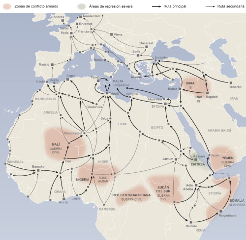
REFUGEES ROUTES TO EUROPE / RUTAS DE LOS REFUGIADOS A EUROPA
Source:El Mundo
More maps on http://geomapping.tumblr.com/
Post link
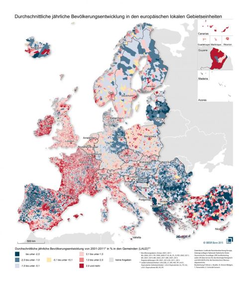
EVOLUTION OF THE POPULATION IN EUROPE (2001-2011) / EVOLUCIÓN DE LA POBLACIÓN EN EUROPA ENTRE 2001 Y 2011
Source: http://www.bbsr.bund.de/
More maps on http://geomapping.tumblr.com/
Post link
WORLD MAP OF DOMINATING WEBSITES / MAPA MUNDIAL DE LAS WEBS PREDOMINANTES
Source:Webempires
More maps on http://geomapping.tumblr.com/
Post link
Two State Solution for the Basque Lands in Northern Spain and Southern France
Dos posibles soluciones al “Conflicto Vasco”
Post link
WORKING IN A GIS PROJECT I FOUND E.T.!! // TRABAJANDO EN UN PROYECTO SIG ME HE ENCONTRADO CON E.T.
Source: Jaime Galeano/Geomapping
More maps on http://geomapping.tumblr.com/
Post link
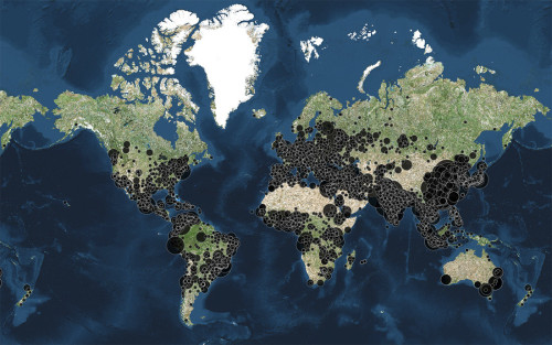
CITIES OF THE WORLD WITH OVER 100,000 INHABITANTS / CIUDADES DEL MUNDO CON MÁS DE 100.000 HABITANTES.
Source: fingolas.cartodb.com
More maps on http://geomapping.tumblr.com/
Post link
COUNTRY OF ORIGIN OF THE 137 VICTIMS IN THE ATTACKS IN PARIS LAST NOVEMBER 13th. / PAÍS DE PROCEDENCIA DE LAS 137 VÍCTIMAS MORTALES DE ATAQUES DE PARÍS DEL PASADO DÍA 13 DE NOVIEMBRE.
Source: The Telegraph, CNN, The Guardian
More maps on http://geomapping.tumblr.com/
Post link
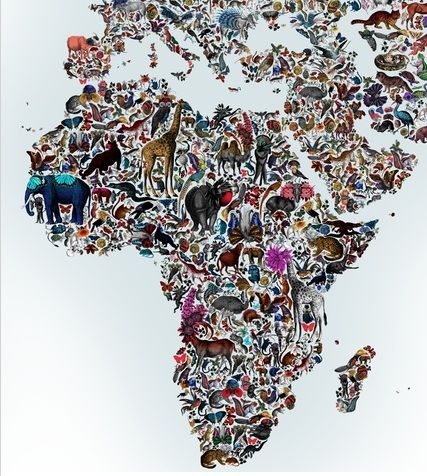
Africa animals by Kristjana S Williams #map#africa
via [Pinterest pinned to the Nordpil Interesting Maps Pinterest Board]
Post link
THE WORLD SEEN BY THE OTTOMAN EMPIRE IN 1803 / EL MUNDO VISTO POR EL IMPERIO OTOMANO EN 1803
Source:Library of CongressMore maps here: www.Geomapping.tumblr.com
Post link
LANGUAGES IN THE WORLD AND ITS PROPORTIONS IN SPEAKERS / LENGUAS EN EL MUNDO Y SUS HABLANTES EN PROPORCIÓN
Source: Alberto Lucas López
More maps here: www.Geomapping.tumblr.com
Post link
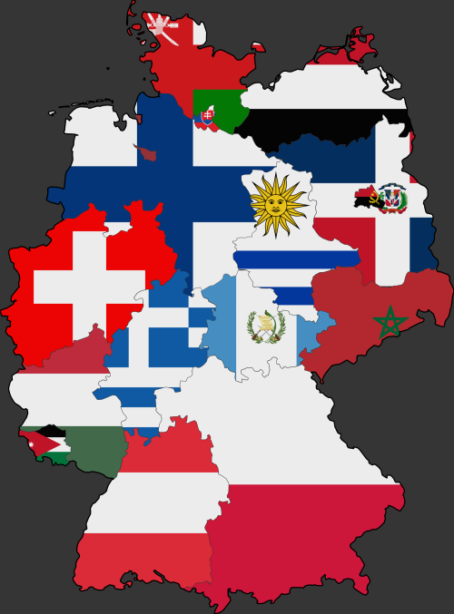
German states colored with the flag of a country with roughly the same GDP.
Regiones alemanas comparadas con países (banderas) con un PIB similar.
Post link


