#drrock


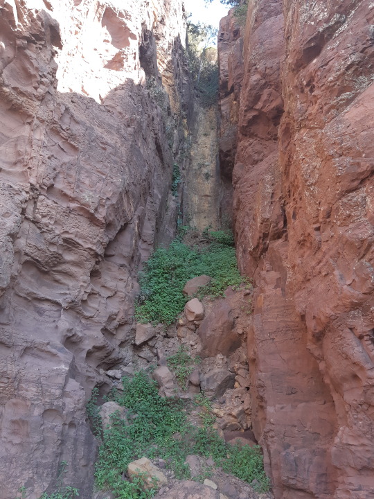
Dykes and landscapes
Dykes most frequently occur as igneous rocks which once were liquid magma that intruded older rocks. Dykes form as sub-vertical to vertical linear sheet-like features and can be millimetres to kilometres wide.
Dykes can contribute to formation of interesting landscape features. For example, in above photograph, the dyke was more resistant to weathering and erosion than the rock it intruded, and so, it gave rise to a tall protruding wall known as the Breadknife, the Warrumbungle National Park. Whereas, in the photograph below, the dyke is less resistant to weathering and erosion, and so erosion of the dyke resulted in formation of a slot or a gully in the cliff near Kiama, south coast NSW.
Erosion of surface features (such as rocks) at different rates is referred to as differential erosion.
Post link

Feeding patterns
These swirly patterns were made by living organisms at the bottom of the sea approximately 250 million years ago while they were feeding on an organic matter mixed within the sediment. The pictured sediments were buried by more sediments, hardened and eventually brought to the surface by tectonic processes without messing up such signs of ancient life.
South coast NSW, Australia
Post link

The dark coloured rock is a sedimentary rock and the bright coloured rock is an igneous rock (used to be a magma) which intruded the sedimentary rock. This intrusive igneous rock is called dyke or dike.
This dyke is bright coloured because the minerals that make up this rocks are breaking down to clays due to exposure to water and oxygen. Original minerals in rocks such as this one are usually black and so dykes often appear dark (but, definitely not a rule!). However, when these minerals breakdown they produce clay minerals, which are usually bright coloured.

The white-orange marks that you can see on the close-up image of the dyke used to be minerals that floated in the magma before it turned into a igneous rock. These minerals were called plagioclase, however, now these too have been converted into clays.
You might notice that approximately all these tabular minerals are aligned in one up-down direction. This the tell-tale sign of magma movement which aligned the mineral according to its flow direction. From this photograph you can narrow down the magma movement direction options to either to up-down and towards-you/away-from-you.
Southcoast NSW, Australia
Post link

Eroded volcanic landscape. Approximately 15 million years ago this used to be a shield volcano (similar in structure to Hawai’i), but since its volcanism stopped the erosion has exposed the sides of the volcano. The most pronounced features are an ancient magma chambers. These would either feed magma to eruptions occurring on the surface or pulses of magma that did not make it to the top and have slowly crystallized at depth.
Warrumbungle National Park, Australia
Post link

Broken shells
As you would find some broken-up shells on the beach today, these are just a few pieces of ancient sea shells from about 300 to 250 million years ago, preserved in the rocks which used to be a sea bottom sediment.
Ulladulla, Australia
Post link

Rocks out of place
Why are these rocks out of place? They just do not fit the environment in which they are. The sea waves that moved the medium to coarse sand that is now the sandstone that surrounds these boulders, are not strong enough to move boulders. There is a huge contrast in mass between the sand and the boulder. So, the only explanation is they were placed here by some other means. For this reason, such rocks are called ‘dropstones’, as they were dropped/placed into their current position, rather than being transported along with the surrounding sediment.
One explanation how this could have happened, is the sea ice. During Permian (~300-250 million years ago) this region was under ice age conditions, with glaciers covering the continent from land to sea. So, whether it was glaciers sliding into the sea, or sea ice enveloping loose boulders around the coast and moving them off into the sea; it is impossible to say exactly. But, because ice floats on water, it provides a good candidate for a mechanism of moving these heavy boulders from the land to the sea bypassing the sea wave transport.
Ulladulla, Australia
Post link

Ichnofossilsortrace fossils, are marks left in the sedimentary record by living organism but are not a body part of the organism. For example, pictured are burrows left by an organism that was feeding on an organic matter in the sediment. These provide an evidence of ancient organism activity after sediment deposition but before it turned into hard rock.
Ulladulla, Australia
Post link

When rock and paper end up with the TIE…
Rockfalls occur when rocks in the cliff face or a steep slope are destabilized and fall due to gravity pull. This can range from few rocks rolling down the hill to a massive rock avalanche that destroys the village. Either way, such moving rocks or a boulders can pick up speed and move with a lot of force, this can be damaging to anything that gets in their way. Bigger rockfalls can completely strip surface vegetation, knock down and uproot trees, damage soil and initiate erosion etc.
Surprisingly, this tree was strong enough to withstand the impact of this multi-tonne boulder rolling down.
Warrumbungles National Park, Australia
Post link


Do not be fooled by this incredibly well preserved shell, it is not a recent shell, but a 250 million year old fossil.
Many different mollusc fossils are very well preserved at this outcrop which consists of layer upon layer of sediment which slowly accumulated on the sea floor during Permian times. Organisms such as this one, would have thrived here, feeding on the organic matter settling down to the bottom of the sea.
Southcoast NSW, Australia
Post link

This wall-like feature is a left over from a plumbing system of an ancient volcano and is called a dykeordike. When this volcano was active, this dyke would have served as a duct through which magma was transport to feed the surface lava eruption, or alternatively it could have been an off-shoot from the magma chamber that froze up within a body of a volcano.
Now, ~15 million years later the erosion has removed much of this volcano and so its internal magma plumbing system is nicely exposed and is dominated hard crystalline rocks which are much harder to erode. Thanks to this contrast in erosion we have a beautiful landscape of the Warrumbungle National Park.
Post link

In the mountains you can get a lot of two things, rocks and sediments produced from the break down of those rocks. In the foreground and in the background around the feet of the mountains you can see two big piles. These are called alluvial fans. It is basically a dump of sediments that was flushed down the small valleys into a big valley. What runs between these two alluvial fans is a major river which is a conveyor belt of the sediment that slowly moves it down the valley, down the mountains, down the floodplains and eventually into the ocean.
See it as a highway for moving of sediment.
Nubra River, Himalaya.
Post link

Giants among the Lilliputians, some diversity in size of bivalves among the sea bottom dwellers from Permian times (~250 million years ago).
Example from south coast NSW, Australia.
Post link

This post is dedicated to YOU!
I am very happy to let you guys know that this is the 200th post on the Dr Rock Club blog. So with this post I wanted to say ‘Thank you’ to all of you for your support!
Let’s celebrate this special occasion with a layer CAKE stratigraphy!
Scene from along Australia’s south coast
Post link


Ancient sea bottom exposed along a modern seaside rocky platform. This immense amount of fossilized shells is preserved in ~250 million year old sea sediments which would have been a feeding grounds for all these bivalves.
South coast, NSW, Australia.
Post link


Every rock that crops out of the ground is a record of the past, and so, in one way or the other it tells something about the environment in which it was formed. For example, the dark grey rock with fine and smooth texture you can see on the photo, looks that way because it formed on deep water sea bottom, where waves did not disturb the sediment that make up this rock, nor coarser sandy material was brought into it. This was a clam environment which allowed the sea-bottom animals to feed on the organic matter within the sediment (hence the dark colour) and is the reason why there are so many fossils in it, which I showed in the ‘underwater lilies’ post.
So, it is all good, and all makes sense!
But, then there are those large pieces of light grey rock (not shown, but some bigger than sedan car) with rough texture and little holes. Like you can see, its pieces are larger than anything else in a vicinity and are scattered all throughout the dark grey rock. This light grey rock does not belong to the sedimentary environment it is in, it got to where it is by other means than the sediment that surrounds it. And so, the plot thickens…
South coast NSW, Australia
Post link

Fossilized bivalve shells buried in an ancient sea sediments are receiving daylight for the first time in ~250 million years. These sediments are rich in iron minerals, which has replaced the carbonate shell material and preserved the original texture of the shell. Thank you iron oxides for preserving the growth layering of this shell for us to admire.
Beach-side outcrop in southeastern Australia.
Post link


Australia’s Bushfire Aftermath
Australia’s east-coast bushfires of 2019-2020 have been extinguished for some time now, but the rafts of charred debris continue to linger on our beaches, leaving a permanent record of the events of last summer.
Such records, when successfully preserved in sedimentary environments, is what scientists study to better understand what fire regimes were like in the past, so we have better idea what is to come.
Warrain Beach, Australia
Post link


Underwater Lilies
These barrel-shaped pieces are fragmented crinoid stems. This type of crinoid was a underwater lily-like creature which fed on the organic matter suspended in the water. Unfortunately, only stems were preserved at this outcrop, other elements were not found.
South Coast, NSW, Australia.
Post link

Lapilli, meaning ‘little stones’ in Latin, can have diverse origins, but the example shown on a photograph is more precisely called accretionary lapilli.
Accretionary lapilli form during a volcanic eruption in the ash cloud. When big volcanic eruption occurs, a volcano will blow a huge cloud into the atmosphere. Such cloud will contain massive boulders, smaller rocks, volcanic ash and gases etc. Rocks are heavy, so they fall back down fast, however, ash and gases do not. The most abundant and important in this process gas is a water vapour.
Mix fine ash and water vapour/steam together and what you get is an airborne mud. Water vapour sticks ash particles together, so as the huge turbulent ash cloud grows and mixes, more and more ash particles come together to form little balls (lapilli) which then rain down like hail once they get too heavy.
This layer formed after such rock rain in Hawai’i Island (Big Island).
Post link
 above sea level, located in weste")
 above sea level, located in weste")
Dunes pictured are at elevation of around 3000 metres (~9850 feet) above sea level, located in western part of the Himalaya Mountains.
Steep valley walls that stick out about 1000–2000 metres (3280–6560 feet) above the valley floor create a narrow corridor. This corridor captures major air mass movements which blow around the sands on the valley floor that eventually make up dunes.
Arch-shaped patters are sand layers within old dunes that have partially eroded. The erosion has exposed the internal structure revealing how the dune was constructed.
Nubra Valley, Ladakh, Himalaya
Post link


The Champagne Pool of the Waiotapu geothermal fields is located on North Island, New Zealand. This hydrothermal pool is always steaming as its waters are heated by volcanic activity deep underground. Array of colours in the pool that you can see, come from either arsenic and antimony metal-based minerals or microbial life that can thrive in extremely acidic, toxic and hot environments.
Post link

Dirt + rock + acid + water = mud pool.
A mud pool that developed in a collapsed pit. Slow loss of water by evaporation or reduced recharge from groundwater caused this mud pool to slowly dry out.
Wai-O-Tapu geothermal fields
Post link

Life on the geothermal fields has many benefits and of course fair few downsides too. Hot steam gushing out of the ground during cold winter provides more than just warmth. Locals actually slow cook their dinners over the steam outlets!
In the morning before work, pop a tray with meat and veggies into the steam built on top of the vent, and when you come back from work, dinner is beautifully cooked and ready for you to dig in! Or, if you prefer a boiled food, just put it all in a net and chuck into a hot spring pool for a bit and you got yourself cooked meal.
Hot springs are rich in alkalis and therefore work well as communal baths, which leave your skin clean and healthy. Obviously, communities assign a purpose for each pool, so no one bathes where others cook!
Whakarewarewa Village, New Zealand
Post link

Wave rock around base of the Uluru monolith in Central Australia. An example of erosion-driven sculpting of the bedrock.
Post link

Volcanic gases puffing out of the ground at the Wai-O-Tapu geothermal fields in New Zealand. Main gases coming out of this vent are water vapour and carbon dioxide, however, many other gases can also be present in trace amounts, but this chemistry is dependent on the geological environment. Sulphur is definitely present in this mixture as can be observed by the yellow sulphur crystals forming around the mouth of the vent.
Post link

This mountain face is made of limestones that were deposited on edge of the Indian continent, that was submerged beneath the ocean separating Eurasia and India many millions of years ago. And now, it peaks at more than 5000 metres above the sea level.
Though karst caves are rare in high mountains, this shallow cavern is now a place of worship for Buddhists from the top-of-the-mountain monastery.
Ladakh, India
Post link

Scene from an ancient sea floor, as if it happened yesterday, however, these are from Permian period (~299–251 million years ago). Some of these fossilized bivalve shells are still articulated, meaning, left and right shells are still closed together. This tells you that particular animal specimen was undisturbed since its death, until now. The hard rock that envelops these shells was once a soft sediment in which these molluscs lived.
South coast NSW, Australia
Post link

Collapsed chamber with sulphur coated walls from volcanic gases. Sulphur is picked up from the rocks deep underground by the steam, that was heated by the magma ponding at depths. At the surface, exsolving gases precipitate the sulphur as the gases mix with the atmosphere.
Wai-O-Tapu, New Zealand
Post link

A hollowed out cavern with a rock art covered walls. One of many found around the base of the Uluru monolith in the landscape of Australian outback flatness.
Post link

Coastal cliff erosion can create pillars when rock jointing or faulting are spaced at favourable intervals and angles. These will continue to be sculpted by the waves and often become tourist hotspots (such as the Twelve Apostles in Australia) or a refuge for sea birds, which can nest safely from predators.
Gannet colony at Muriwai, New Zealand
Post link


Inside the plumbing system of an ancient volcano
A fossil plumbing system of an ancient Waitakere Volcano. Though the volcano went extinct and was largely eroded away, the lava flows that once spew from it are now preserved along the Maori Bay coast. The radial feature is an internal view of lava flow lobe that shows rosette style columnar jointing. This feature forms when large lava flow moves and cools slowly, allowing columns to grow, which at the same time are bent due to ongoing lava movement.
Muriwai, New Zealand
A detailed description of this flow is available in the following article:
Bear, A.N. and Cas, R.A.F., 2007. The complex facies architecture and emplacement sequence of a Miocene submarine mega-pillow lava flow system, Muriwai, North Island, New Zealand. Journal of volcanology and geothermal research, 160(1-2), pp. 1-22.
Post link

Barron Falls is a result of plate tectonics at their best. Eastern part of Australia was separated from the current mainland, sinking under the sea, while leaving an escarpment on the mainland. This is the escarpment and it has been eroding since that time. Left are cascades which formed by river flowing over the edge of the escarpment.
Kuranda, North Queensland
Post link

Finke River of Central Australia
This is Finke River which is a dry riverbed most of the time just like many other rivers in the Central Australia. Such rivers flow on the surface during powerful rainfalls, which can turn this dry sand patch into raging torrent. Water does not last long on the surface in the desert areas, and so it either evaporates or soaks into the soil where it then slowly makes its way into the artesian basin (underground water pool, the groundwater system). Actually, the groundwater is a major water source for people living in the dry centre of Australia.
Fun fact!
The upper section of the Finke River was deduced to be around 350 million years old, what makes it one of the oldest rivers in the world. It means it has flown across the continent long before the proto-dinosaurs have even evolved.
Post link


Surface smoothed by grinding practice by people that once occupied caverns around the Uluru.
Post link

Rain droplets preserved in dry desert sand. These tiny impressions, if buried by more sand, can be preserved for hundreds of millions of years and provide geologists with important clue that the rock containing them formed on the surface rather than under water.
In other words, it is a trace fossil of rain.
Post link

Mineral under pressure
This is a photograph of mineral called pyroxene and was taken with a petrographic microscope, and it captures megascale forces of the tectonic processes on the microscale level. This mineral is about 1.5 mm and was found in a rock called greenschist.
This rock is heavily deformed, sheared, due to the force of the tectonic plates pushing against each other. Imagine one plate being a bread and other a knife, and the rock you are looking at is like a butter being smeared on the toast.
The pyroxene is harder than the rest of the minerals in this rock, and so, as the pressure is applied, the other minerals are deformed and squashed against the pyroxene while it remains largely undamaged.
Example from the Nubra Valley, Ladakh, Himalaya
Post link

Leucogranite
Pleasant to look at outcrop along the road in Alice Springs. A leucogranite (white/bright granite) dykes intruded along foliation plane of the gneiss.
Post link